CIESM investigations point to drastic hydrological changes in the western Mediterranean CIESM investigations point to drastic hydrological changes in the western Mediterranean
30 November 2005, CIESM News
The Strait of Gibraltar is a “strategic” location for monitoring the state of the Mediterranean Sea. There, close to the sea bottom, a sensor operated by CIESM as part of its Hydrochange program continuously records long-term changes in salinity and sea temperature on an hourly basis. In this narrow strait, the Mediterranean outflow passes through and continues in the Northern Atlantic, where it contributes to the formation of the North Atlantic Deep Water.
Data collected by the CTD sensor are retrieved every year by CIESM scientists working in close cooperation with SHOMAR (Moroccan Hydrographic Service). The period 2003-2004 has now been analysed and compared with previously collected values (see Figure 1). They reveal a drastic, unexpected change: today the Mediterranean outflow is much warmer (~0.3 °C) and more saline (around 0.06 units saltier) than the densest water outflow 10 years ago. |
|
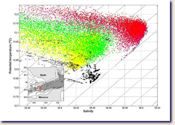 |
Figure 1: The diagram displays the sea potential temperature (vertical axis) and salinity data (horizontal axis) collected at a depth of 270 m at the Gibraltar monitoring station, in the years 1985-1986 (black), 1994 (yellow), 1996 (green) and the period of January 2003 - April 2004 (red). The figure shows that the outflow of the Mediterranean (taking place in the narrow passage of the Strait of Gibraltar as indicated by the insert map) today is clearly warmer and saltier than two decades ago.
|
|
|
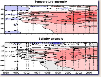
Temperature and salinity values recorded in the deep waters of the Tyrrhenian Sea, between the island of Sardinia and the Italian peninsula, indicate increases as well since 1992. This trend was confirmed by the results of the recent CIESM SUB1 campaign. During this cruise, CIESM scientists added important measurements to the time series indicating that the extension of warmer and saltier waters now covers almost the entire water column (see Figure 2), after a visible peak measured in the intermediate layers (700-1800 m) during the period 2000-2002. |
|
Figure 2 : The upper graph displays the temperature anomaly, the lower shows the salinity anomaly (in each case the reference date is 1988). The evolution of the anomalies is indicated for the entire water column (0-3000 m) from 1988 until present. Small anomalies in blue; larger anomalies in red.
Whether these hydrographic observations in the western Mediterranean sub-Basin reflect an ongoing climatic trend, and/or a change in the oceanographic circulation pattern, is an open question. According to the water mass characteristics, it is possible that the main Gibraltar outflow now originates mostly from the eastern Basin. The findings in the central Tyrrhenian Sea may be explicable by an advance (intrusions of dense water via a series of cascading effects through the Sardinia-Sicily Channel) of water masses of eastern sub-Basin origin.
|
CIESM is actively pursuing these issues with further investigations through its expanding Hydrochanges program and with the forthcoming CIESM SUB2 campaign.
|
More information
- on the CTD data of the Strait of Gibraltar contact J.-L. Fuda (CIESM Hydrochanges program)
- on the thermohaline data of the Tyrrhenian Sea contact G. Budillon (CIESM SUB1 chief scientist)
|
|
|