QUATERNARY MARINE TERRACES IN THE ALBORAN INSULAR SHELF: TECTONICS VERSUS
SEA LEVEL CHANGES
Bárcenas P.
1
, Vázquez J.T.
1*
, Díaz del Río V.
2
and Fernández-Salas L.M.
2
(1)
Dpto. de Geología, Facultad de Ciencias del Mar, Universidad de Cádiz. CASEM, Campus Río San Pedro, E-11510
Puerto Real, Spain - * juan.vazquez@uca.es
(2)
Instituto Espańol de Oceanografía. Centro Oceanográfico de Málaga. Puerto Pesquero s/n, E-29640 – Fuengirola, Spain
Abstract
On the basis of high-resolution seismic profiles and sonographic records supported by bathymetric data we propose a comprehensive
description of the marine terraces evolution in the area surrounding the Alboran island, placed in the northeastern corner of the Alboran
ridge, in relation to neotectonic activity and sea level changes during the Quaternary.
Keywords: Marine terraces, insular shelf, neotectonics, Alboran bank, Western Mediterranean Sea.
Rapp. Comm. int. Mer Médit., 37,2004
7
Introduction
The Alboran Sea is situated in the inner part of the western Alpine
orogenic belt (Betic-Rifean ranges) between Eurasian and African
plates. This region has an important oceanographic dynamic
consequence of the Atlantic-Mediterranean water masses inter-
changes through the Strait of Gibraltar. The Alboran sea ?oor shows a
very complex physiography constituted by sub-basins, structural
highs and platforms as a consequence of the close relationship
between geomorphology, tectonic, diapirism, volcanism and water
deep circulation (1). The most important seamount located in the
basin is the Alboran Ridge showing a NE-SW direction. The main
feature of this basin is situated in the northeastern sector
corresponding to the Alboran Island Bank. The main feature of this
bank is the presence of an isolated insular shelf (2) surrounded by the
slope domain and disconnected by the nearer continental areas.
Methodology
The data were obtained using a sub-bottom profiler (ORE 3.5 kHz)
and echosounder (Furuno FUG 11), from 0 to 500 m depth, and also
a side scan sonar (EG&G, 500 kHz) ranging from 0 to 60 m depth.
Two oceanographic cruises (Coral 8209 and Alboran 9409 developped
by IEO) were performed. From the study of these data we have
obtained the detailed description and morphologic mapping of the
Alboran Island Bank.
Morphologic characteristics of the Alboran insular shelf
The Alboran insular shelf is characterized by an irregular
morphology. The maximum extension is 27.75 km and the mean
width range between 5 and 6.5 km (Fig. 1). The longitudinal axis of
the shelf follows a NE-SW main trend and the emerged area
corresponding with the Alboran Island. The breakshelf appear in
different depth with average values between 110 and 120 m and
followed by a variable slope more abrupt in the southern ?ank (3).
Nine morphological types have been described in the Alboran shelf
related with the genesis processes: a) erosive: marine terraces,
submarine scarps, depressions, channels and edges; b) sedimentary:
sediment waves and sediment wave fields; c) tectonic and/or
inherent: morphological highs and stepped shelf. The erosive
processes are dominant in the shelf, followed by the tectonic process
with are more developed in the southern sector (3). Marine terraces
levels are the most relevant morphological type in this shelf and they
are the issue of this communication.
Marine terraces
Three marine terraces types have been differenced in the Alboran
shelf related to the eroded material and the presence of associated
sedimentary bodies (Fig. 1): a) marine terraces over hard ground or
basement, b) marine terraces over sedimentary bottomand c) marine
terraces with associated sedimentary body. It has been observed 25
levels of marine terraces without associated sedimentary bodies,
among 10 and 95 m in depth (3), presenting the highest frequency
between 70-85 m depth and followed by the levels located in the 65-
70 m. The marine terraces with associated sedimentary body have
been located at 65, 68, 72, 78, 83, y 93 m depth, being more abundant
between 85-90 m and 70-75 m.
Comparing the marine terraces steps in southern and northern
?anks we point out the existence of steps at 10-15, 20, 24, 26, 28, 30-
35, 38, 42, 44, 53, 65, 68, 70, 72, 75, 78, 89 and 95 placed on both
?anks, whereas the remaining steps recorded are located in the
southern shelf. These results are in agreement with those reported
previously in the area ?anked by Malaga and Gibraltar (4) and in the
Mediterranean area (5), excluding the levels showed in the southern
shelf, which have not been observed before by others authors. The
marine terraces in the shelf have been related with short sea level
stillstands during the last sea level rising (Flandrian transgression).
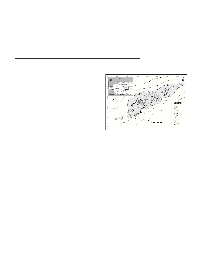
Fig. 1. Marine terraces levels distribution on the Alboran insular shelf.
Legend: 1. Continental shelf, 2. Breakshelf, 3. Marine terraces over hard
ground or basement, 4. Marine terraces sedimentary bottom, 5.
Sedimentary body associated to marine terraces, 6. Tilted marine ter-
races, 7. Submarine scarps, 8. Marine terraces associated to fault, 9.
Fault scarps and, 10. Alboran Island.
On the other hand, this area is characterised by an important
seismic and tectonic activity (2), with tilted terraces and terraces
associated to fault in the southern ?ank described in the area. In this
way, the sea level change process should be the origin of the terraces
steps. In the southern ?ank should be more likely a higher neotectonic
origin than an high level process.
References
1-Maldonado, A., Campillo, A.C., Mauffret, A., Alonso, B., Woodside, J.
y Campos, J., 1992. Alboran Sea Late Cenozoic Tectonic and Stratigraphic
Evolution. Geo-Marine Letters, 12: 179-186.
2-Vázquez, J.T., 2001. Estructura del Margen Septentrional del Mar de
Alborán. Tesis Doctoral, Universidad Complutense de Madrid, Madrid,
422 p.
3-Bárcenas, P., 2002. Morfología submarina y evolución reciente del
Banco de la isla de Alborán. Tesis de Licenciatura, Universidad de Cádiz,
Cádiz, 234 p.
4-Hernández Molina, F.J., Gracia, F.J., Somoza, L. y Rey, J., 1996.
Distribución batimétrica de las terrazas submarinas en la plataforma
continental de Málaga-Gibraltar. Implicaciones eustáticas durante el
Cuaternario terminal. Geogaceta, 20(2): 416-419.
5-Flemming, N.C., 1972. Relative chronology of sumerged pleistocene
marine erosion features in the Western Mediterranean. Journal of
Geology, 80: 633-662.