COASTAL EVOLUTION IN WESTERN ANATOLIA DURING THE LAST FIVE MILLENNIA
Helmut Brückner
Department of Geography, University of Marburg, D-35032 Marburg, Germany
h.brueckner@staff.uni-marburg.de
Abstract
The progradation of the Büyük Menderes delta and ?oodplain during the last 5000 years led to the total silting up of the former Latmian
Gulf. By geoarchaeological means this delta growth is reconstructed in space and time, and the results then cross-checked with information
from archaeological and (pre-) historical sciences. As synthesis, a scenario for the landscape evolution during the last five millennia is
presented.
Keywords: Turkey, Büyük Menderes, Miletus, delta growth, geoarchaeology, Holocene.
Rapp. Comm. int. Mer Médit., 37,2004
12
The delta regions of western Anatolia witnessed the strongest
coastline changes during the Holocene. In this paper this is exem-
plified for the Büyük Menderes (Maiandros) delta and ?oodplain. The
impact of these processes on the former harbour cities Myous, Priene
and Miletos are especially of interest since they lost their economic
and strategic basis due to the siltation of their harbours. The relevant
references for this topic are summarized in Brückner (1) and Brückner
et al.(2). The new scenario of the landscape evolution, based on our
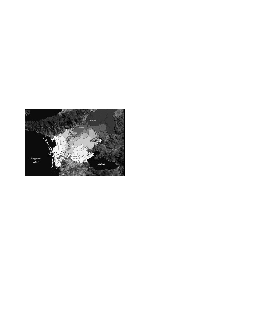
geoarchaeological data, is presented in Fig. 1.
Fig. 1. Progradation of the Büyük Menderes delta during the past millen-
nia.
Note that during the peak of the Holocene transgression ca. 5,000-
6,000 years ago, the marine gulf extended much further eastward
covering the whole area of the ?oodplain visible in this figure. In the
figure, a given age refers to its nearest seaward coastline.
Potential Archaic to Classical Greek harbour sites were identified in
the embayments west of the Myousian peninsula, i.e. between Castle
hill and Settlement hill, and south of Settlement hill. In the vicinity of
Myous, the transiton from marine to lacustrine facies must have
occurred already in Hellenistic times. Lagoonal conditions prevailed
in Hellenistic-Roman times. In the southwest, the lacustrine
environment started in the 1
st
or 2
nd
century A.D. and partially
prevailed until Modern times. In the east, the brackish and shallow
Lake Azap is what remains of the former marine embayment.
Priene was founded anew in Late Classical time around 350 B.C.
Under palaeogeographic perspective the most interesting question is
that of the harbour site(s), a topic whereof the historic sources remain
silent. Ceramic and 14C stratigraphies of drill cores led to the
following conclusions: In the eastern embayment, marine conditions
prevailed at least until the 13
th
/12
th
century B.C. Thereafter, a slight
regression can be proven by a peat dating from the second half of the
2
nd
millennium B.C. In the mid-4
th
century B.C, this embayment had
already turned into a freshwater lake. For that time, a potential
harbour site can be ascertained in the western embayment where
water depth was still several metres and a lagoonal environment
existed until the beginning of the Roman Imperial era. Definitely
freshwater milieu did not exist before the 3
rd
century A.D. This
embayment was filled with sediments more slowly than its eastern
counterpart since it was sheltered from alluviation by the river due to
the leeward position behind the promontory of the Priene rock.
During the peak of the Holocene transgression, the area of the later
city of Miletos was composed of islands. One of them hosted the
earliest settlement in the area of the later Athena Temple dating from
the second half of the 4
th
millennium B.C. When the Minoan settlers
arrived around 1900 B.C. this island topography is likely to have
persisted; however, hints of an already existing connection with the
adjacent mainland by a sandbar (tombolo) cannot be neglected. The
palaeogeographic setting changed to a peninsula during the Minoan-
Mycenaean occupation phase. The sediments were mobilized by
coastal longshore drift and human-induced denudation from the
adjacent slopes. It is at least since the Archaic period that the Milesian
peninsula extending into the Latmian Gulf is known from literary
sources and archaeologic evidence (city wall). The Roman time – and
especially the Roman Imperial era – witnessed strong siltation
processes around Miletos.
Tradition has it that the Milesian peninsula had four harbours, of
which only the Lions’Harbour and the Theatre Harbour have been
definitely identified to date. Our research in the Lions’Harbour
showed an enormous increase in siltation between the 1
st
century B.C.
and ca. A.D. 400. Corings within the Theatre Harbour unearthed no
artifacts older than the Roman Imperial era; therefore, it must have
been dredged in the 1
st
or 2
nd
century A.D. when also the theatre was
renovated. The geoarchaeological approach also revealed that a good
natural setting for the third harbour was given close to the earliest
settlement near the later Athena Temple. Another potential harbour
most likely existed to the east of the Milesian peninsula, in a leeward
position to winds from the west.
The data set of archaeological and
14
C ages is suitable for the
establishment of a locally valid sea level ?uctuation curve for the
Holocene. It seems to have a relative peak around 6-5 ka BP, after the
strong late Pleistocene – Holocene sea level rise, and a relative low
around 3 ka BP. This shape of this curve is similar to that of K
AYAN
(1995) established for the Troia (Troy) region. However, in our case
this glacio-eustatic curve is shifted downward by the factor of 0.7
m/ka due to the ongoing subsidence of the Menderes graben. It is
important to note that in several other regions of the Mediterranean,
sea level reached its highest position during the Holocene only today
and was definitely lower around 5 ka BP.
References
1-BrücknerH.,2003. Delta evolution and culture. Aspects of
geoarchaeological research in Miletos and Priene. Pp. 121-144. In:., G.A.
Wagner, E. Pernicka and H.P. Uerpmann (eds.), Troia and the Troad –
Scientific approaches. Springer Series: Natural Science in Archaeology.
Berlin, Heidelberg, New York.
2-Brückner H., Müllenhoff M., HandlM. andvan der Borg K., 2002.
Holocene landscape evolution of the Büyük Menderes alluvial plain in the
environs of Myous and Priene (Western Anatolia, Turkey). Z. Geomorph.
N. F., Suppl.-Bd. 127: 47-65, Berlin, Stuttgart.
3-Kayan I., 1995. The Troia Bay and supposed harbour sites in the
Bronze Age. Studia Troica, 5: 211-235.