DEEP STRUCTURES OF THE NILE CONTINENTAL MARGIN AS DEDUCED
FROM COMBINED MULTI-CHANEL SEISMIC REFLECTION AND GRAVIMETRY DATA
Laurent Camera
1*
, Nicolas Chamot-Rooke
2
, Françoise Sage
1
, Jean Mascle
1
and Medisis Scientific party
1
Geosciences Azur, UMR 6526, BP 48, 06235 Villefranche-sur-Mer, France
2
Laboratoire de Geologie, CNRS-UMR 8538, ENS, 24 rue Lhomond, 75231 Paris, Cedex 05, France
Abstract
The Egytian continental margin sedimentary cover include at least three main contrasted sequences. From top to bottom: a post Miocene,
2/3km thick on average, blanket which constitutes most of the Nile deep sea fan; a Messinian unit made of massive evaporites locally more
than 2km thick, and submitted to important gravity gliding, and finally, a pre-mesinian, poorly known Mesozoic to Cenozoic cover which
represents the pre, syn and most of the post-rift sequences of this segment of the african passive margin of Mesogea. Our results based on
MCS and gravity data are a preliminary attempt to investigate this deep sedimentary and crustal sections of the Egytian margin.
Key words: Eastern Mediterranean/ Nile deep margin/ seismic-gravity
Rapp. Comm. int. Mer Médit., 37,2004
13
Most of the Egyptian continental margin is presently covered by the
Nile deep-sea fan, a huge terrigenous construction of upper Cenozoic
age resting on various Messinian deposits, including thick evaporites,
themselves submitted to regional gravity tectonics [1]. It is generally
agreed that the Egyptian continental margin represents a segment of a
passive margin, the Mesogean margin of Africa, believed to have
initiated in Mesozoic times (Jurassic to early Cretaceous, depending
of the authors) in response to rifting processes leading to the opening
of an oceanic space, whose remnants (the deep Eastern Mediterranean
sea basins) [2, 3, 4] are now almost entirely consumed at the level of
the Hellenic/Cyprus subduction zones. Despite considerable sets of
geophysical data obtained by oil companies, but not yet available,
little is still known on the deep structures of this passive margin
which, moreover, may have been partly re-activated in Miocene times
as a consequence of the the Red Sea/Gulf of Suez rifting. For
example, the exact location of the transition zone between continental
and oceanic crusts, or the tectonic fabrics, inherited from rifting and
now deeply buried, are still pending questions. To our knowledge no
seismic refraction data are yet available within this area of the Eastern
Mediterranean, with the exception of an expanded seismic experiment
recorded more than 10 year ago across the Herodotus abyssal plain
[5]; Moreover the presence of massive, and unstable, Messinian
evaporite layers [1], locally as thick as 3 km, and characterized by
high seismic velocities, has considerably restricted sesimic imaging
from academic seismic re?ection surveys
This work is a preliminary attempt to better image, and constraint,
the deep structures ( sedimentary and crustal) of this passive margin
segment. It is based on a combination of two sets of data: (1) Recently
(2002) recorded deep penetrating (MCS) data [6]; (2) Marine gravity
data, previously (1998) recorded on the entire deep sea fan, and
themselves completed by Seasat derived data (Sandwell; 10).
In July 2002 about 1600 km of MCS data, using an array of 8 guns
and a 5km long, 360 channels, digital streamer, have been recorded
along seven regional lines, either perpendicular or parallel, to the
present slope general trend (see Fig. 1). The use of standard
processing packages (Geovecteur) has already allowed to better image
several characteristics of the deep structures of the margin [6] and has
particularly shown that, below spectacular thin-skin salt-related
shallow structures (particularly well-expressed in the Eastern margin
area), deeply sedimented basins exist. These basins contain strong and
well-layered, re?ector sequences detected up to 10 stwt (see Fig. 2)
and interpreted as indicative of Mesozoic and subsequent deposits [7].
Locally, deep re?ectors (around 11/12 stwt) may indicate transitional
zone to thin layered lower continental crust, or even to the Moho.
Below the Herodotus abyssal plain, re?ectors well correlated with
ESP data [5]. are from top to bottom identified as indicative of the
Plio-Quaternary cover, the thickened evaporites, the mesozoic to
cenozoic sediments, the top of the oceanic crust and even the Moho.
Different tests of pre-stack depth migration have been succesively
performed on one of the MCS lines (Line MD 06) to better asses the
sedimentary thickness and to better image the deep margin
architecture.
The seismic data have then been used to constrain preliminary
crustal models for the Egyptian margin based on gravimetry data.
References
1-Loncke, L., 2002. Le delta profond du Nil : structure et évolution
depuis le Messinien (Miocčne terminal), Thčse de doctorat de l’Université
Pierre et Marie Curie, Observatoire Océanologique de Villefranche-sur-
Mer, Geosciences Azur, 404 p.
2-Biju-Duval, B., Letouzey, J., and Montadert, L., 1978. Variety of
margins and deep basins in the Mediterranean. AAPG bulletin: 293-317.
3-Geiss, E., 1987. A new compilation of crustal thickness data for
Mediterranean area. Annales Geophysica, 5B: 623-630.
4-Hirsch, F., Flexer, A., Rosenfield A. and Yellin-Dror, A, 1995.
Palinspatic and crustal setting of the Eastern Mediterranean. Journal of
Geology, 18: 149-170.
5-De Voogd, B., Truffert, C., Chamot-Rooke, N., Huchon, P., Lallemand,
S. and Le Pichon, X., 1992. Two-ship deep seismic sounding in the basins
of the Eastern Mediterranean Sea (Pasiphae cruise). Geophysical Journal
International,109: 536-552.
6-Mascle J., Camera L., Chamot-Rooke N, et al.2003. New constraints
on the deep structure of the eastern mediterranean sea from new mcs
seismic re?ection data. Geophysical Research Abstracts, 5/ 09172-2003.
7-Aal, A.-A., El Barkooky, A., Gerrits, M., Meyer, H.-J., Schwander, M.
and Zaki, H., 2001. Tectonic evolution of the Eastern Mediterranean basin
and its significance for the hydrocarbon prospectivity of the Nile delta
deepwater area. GeoArabia,6, 3: 363-384.
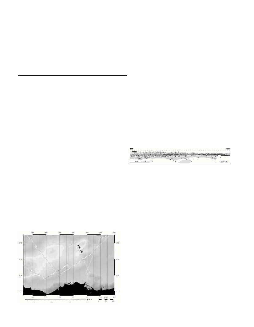
Fig. 1. Track line of Medisis survey over a Bouguer anomaly compilation.
Fig. 2. Tracing of MD O6 line from preliminary Geovector processing.
Below thin-skin salt-related tectonic features, deep sedimentary
basins, characterized by strong and well-layered re?ector packages
(interpreted as Mesozoic to early Cenozoic sediments), are detected
up to 10 stwt.