DISCOVERY OF WIDESPREAD SUBMARINE SLIDES REWORKED BY BOTTOM CURRENTS
ON THE SOUTHERN ADRIATIC CONTINENTAL SLOPE
Cattaneo A.
1*
, Minisini D.
1
, Trincardi F.
1
, Verdicchio G.
1
, Asioli A.
2
and TOBI team
3
1
ISMAR (CNR), v. Gobetti 101, 40125 Bologna, Italy - *antonio.cattaneo@bo.ismar.cnr.it
2
IGG (CNR), Padova, Italy
3
SOC, Southampton SO14 3ZH, UK
Abstract
A recently acquired TOBI side-scan sonar mosaic shows evidence of widespread collapsing of the South Adriatic continental slope. The
new sea?oor images, accompanied by VHR Chirp sonar profiles, reveal: 1) multiple overlapping slide scars affecting Pleistocene regressive
shelf-margin deposits below the shelf edge; 2) extensive blocky slides on the lower slope; 3) evidence of strong bottom currents (presence
of sediment drifts and furrows); and 4) a basin wide acoustically-transparent deposit up to 40 m thick, buried under a late-Pleistocene-
Holocene mud section, in water depths greater than 1000 m.
Keywords : TOBI, Adriatic Sea, submarine slides, sediment drifts
Rapp. Comm. int. Mer M�dit., 37,2004
16
The southwestern Adriatic slope was investigated to improve the
understanding of sediment transport from the north and across the
slope area. Little was known on the complex morphology of this area,
but several published cores reported high, though not uniform nor
steady, sediment accumulation rates throughout the last ca. 30 kyr [1].
The southwestern Adriatic Sea is characterised by high gradients
(1-4%) and the presence of tectonic features (Gondola fault, Dauno
Seamount) and several incisions, locally breaching the shelf edge and
considered active during glacial lowstands, as the Bari canyon [2].
Seismic-stratigraphic correlations indicate that the Bari canyon was
downcut repeatedly during the last few eustatic falls. In particular, the
recent-most regressive sequence recording the interval from Oxygen
Isotope stages 5 to 2 is downcut by the multiple heads of this complex
sediment conduit [2]. Preliminary surveys showed evidence of sedi-
ment instability affecting lowstand shelf-margin deposits and thick
graded turbidite beds at the base of the slope [3]. The TOBI survey,
undertaken during the SAGA2003 cruise onboard R/V Uraniawithin
the Eurostrataform project (EC Contract EVK3-CT-2002-00079), first
showed large-scale submarine slides, the 3-dimensional shape of large
along-slope sediment drifts, the morphology of the Bari canyon, and
helped understanding the extent and nature of mass-failure deposits
and the complex relation between mass wasting and sediment
deposition by bottom currents.
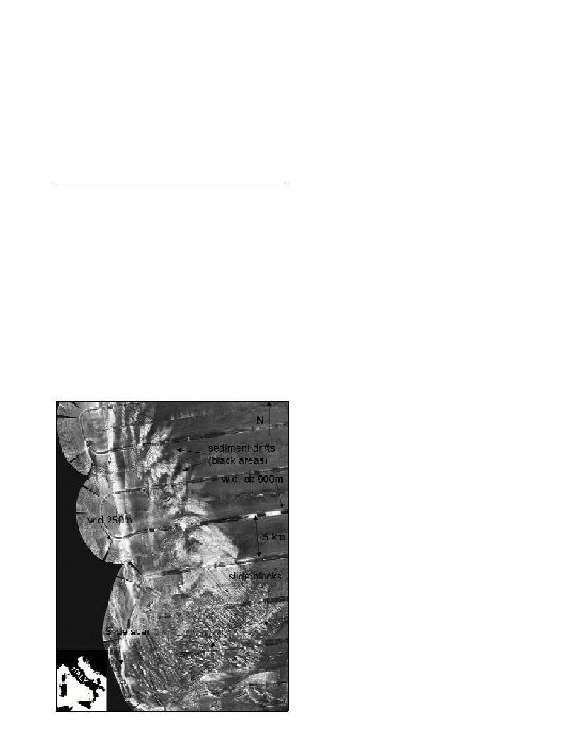
Figure 1 represent part of the TOBI survey with extensive slide
scars on the upper slope (left) and relatively recent mass-failure
deposits transported to NE on the lower slope and in the adjacent
basin. Slide blocks are acoustically-transparent deposits (in seismic
lines) with no internal bedding and size up to 200x500 m. Lateral
variations in internal seismic-reflector geometry and seafloor
morphology of the mass-transport deposits re?ects, likely, along
margin differences in sediment composition and thickness of the
failed section as well as highly variable runout of the failed materials
(exceeding at times 40 km). TOBI data show that the entire slope area
is swept by bottom currents generating: furrowed areas extending up
to 10s of km
2
; moats or scours on the downdrift side of sea?oor
irregularities (slide blocks); and preferential sediment deposition on
the inferred updrift side of the same irregularities. The NW-SE pattern
of furrows is consistent with the growth of sediment drifts located in
400-600 m w.d. to the north.
Relative sea-level fall has long been considered as a possible
predisposing or triggering mechanism for sediment failure. While the
evidence of mass-failure events during falling sea level and lowstand
is common, the occurrence of mass-failure during the late-Quaternary
sea-level rise is increasingly being recognized [4]. Preliminary
correlation to published cores in the area indicates that the main mass
transport deposit reached the basin ?oor during the Last Glacial
Maximum, but younger failures of smaller size may have affected the
slope more recently. Future work will focus on the definition of
intervals of growth vs. quiescence of the sediment drifts and their
possible relation to paleoceanographic reconfigurations and timing of
sediment failure.
References
1-Jorissen F.J., Asioli A., Borsetti A.M., Capotondi L., De Visser J.P.,
Hilgen F.J., Rohling E.J., Van De Borg K., Vergnaud-Grazzini C.,
Zachariasse W.J., 1993. Late Quaternary central Mediterranenan
biochronology. Mar. Micropal., 21: 169-189.
2-Ridente D., Trincardi F., 2002. Eustatic and tectonic control on
deposition and lateral variability of Quaternary regressive sequences in the
Adriatic basin. Mar. Geol.,184: 273-293.
3-Cattaneo A., Correggiari A., Trincardi F., 2002. Recognition of
turbidite elements in the late-Quaternary Adriatic basin: where are they
and what do they tell us?CIESM WorkshopSeries, n.17: 23-28.
4-Trincardi F., Cattaneo A., Correggiari A., Mongardi S., Breda A., Asioli
A., 2003. Submarine slides during relative sea level rise: two examples
from the eastern Tyrrhenian margin. Pp. 469-478. In: Locat J., Mienert J.
(eds.), Submarine Mass Movements and their Consequences. Kluwer,
Amsterdam.