STRATIGRAPHY AND SEDIMENTARY FACIES OF THE LLOBREGAT DELTA
FROM GEOTECHNICAL MEASUREMENTS
S. Colŕs
1*
, J.L. Casamor
1
, M. Canals
1
, J.M. Devincenzi
2
1
GRC Geocičncies Marines, Dept. d’Estratigrafia, P. i Geocičncies Marines, Universitat de Barcelona, E-08028, Spain
2
IGEOTEST, E-17600, Spain
Abstract
A 3D model ofthe Llobregat Delta has been constructed from CPT and CPTU measurements. This model shows the spatial distribution
of sedimentary facies including beach sands, ?oodplain silts and clays, delta front sands and silts, and prodelta silts and clays. Each facies
is described in terms of mechanical properties namely cone tip resistance (q
c
) and friction ratio (FR%). Groundtruthing of lithologies is
provided by continuous cores in control boreholes. Moreover, key surfaces for sequence stratigraphic interpretation, like transgressive and
maximum ?ooding surfaces, have been identified.
Keywords: Geotechnical measurements, stratigraphy, sediment facies, Llobregat Delta
Rapp. Comm. int. Mer Médit., 37,2004
18
The present study is based on Cone Penetration Tests (CPT) and
piezocone tests (CPTU) from a geotechnical study carried out prior
to the construction of a new sewage treatment plant (EDAR) on
the delta plain of the Llobregat River. 70 CPT/CPTU tests and 20
boreholes with continuous core recovery were performed within a
1.2 x 0.25km
2
area. Despite of its small size, the study area is con-
sidered to be representative of the deltaic system because of its location
near the current river mouth and orientation parallel to the river
lowermost course. Both methods provide a high measurement rate of
the soil resistance (q
c
) and friction (f
s
) recovered every 1 to 2 cm.
CPT/CPTU data combined with continuous cores are widely used for
the geotechnical and sedimentological characterization of soft soils [1].
The data set has been used to construct a 3-D model using the
minimum tension gridding (MTG) method. This technique has the
advantages of its simplicity. In addition, it does not require large
calculation times. The modelling results unveil the internal structure
of the delta by illustrating the spatial distribution of sedimentary units
and q
c
trends. The results obtained through the MTG method are
supported by previous results from the same study area using kriging
algorithms [2].
Within the general architectural frame, our study allows
differentiating ?uvial channel sands, beach ridge sands, crevasse
sands, delta front sands, silts and clays, and prodelta silts and clays.
Each facies is described in terms of its mechanical properties, namely
q
c
and FR%. Groundtruthing of sediment facies is obtained from
continuous cores in control boreholes (Fig. 1). Plotting q
c
versusFR%
on Robertson’s et al.chart [3] with inclusion of sediment facies allows
establishing q
c
-sediment facies correlation.
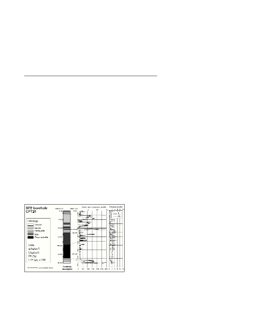
Fig. 1. CPT21 results plotted in parallel with the sediment log from a
close borehole SP2. The correlation between soil resistance (q
c
) values
and the borehole lithological description becomes evident. The friction
ration curve is also provided, since it is used jointly with q
c
to develop
the q
c
-sediment facies correlation. The tree main sedimentary units are
correlated: an upper sandy level between 5 and 20 m of depth, an inter-
mediate level made of silts and clays with about 30 m of thikness, and a
lower coarse level. This stratigraphic sequence represents the generally
assumed deltaic coarsening-upwards sequence of prodelta and delta-
front facies overlain by fine sediment attributed to the ?oodplain.
Relative sea-level stillstands have been identified from the location
of landwards stepping beach ridge sands in the 3D model at 7, 13, 18
and 25 m of depth below the current sea-level. Their distribution can
be attributed to retrogradational deltaic sequences formed during
periods of relative stillstand within the transgressive systems tract
related to the last post-glacial sea-level rise and subsequent shoreline
migration. This fact allows to infer four relative sea-level stages
associated to the upper part of the Versilian transgression, likely from
about 11000 to 6000 yBP. Two additional, seaward shifted, uppermost
beach ridge sands have been interpreted as representing two
progradational phases associated to the highstand systems tract. This
corresponds to a sustained delta growth and shoreline advance phase
favored by a estabilization of the sea-level since 6000 yBP onwards.
References
[1]-Amorosi, A. and Marchi, N., 1999. High-reslution sequence
stratigraphy from piezocone test: An example from the late Quaternary
deposits of the southeastern Po plain. Sedimentary Geology, 128: 67-81.
[2]-Devincenci, J.M., Colŕs, S., Falivene, O., Canals, M. and Busquets,
P., 2003. Aplicación del piezocono para el estudio sedimentológico de
detalle de los sedimentos cuaternarios del Delta del Llobregat, Barcelona.
Proceedings III Congreso Andaluz de Carreteras, Sevilla, Espańa,
Octubre 2003.
[3]-Robertson, P.K., Campanella, R.G., Gillespie, D. and Greig, J., 1986.
Use of piezometer cone data. Proceedings of the ASCE Special
Conference in situ ’86: Use of in situtests in geotechnical engineering,
Blacksburg, 1263-80, American Society of Engineers (ASCE).