Rapp. Comm. int. Mer Médit., 37,2004
28
SPATIAL DISTRIBUTION AND STRATIGRAPHIC ARCHITECTURE OF THE
ALMANZORA RIVER PRODELTA FROM SOUTHEASTERN SPAIN (PALOMARES, ALMERÍA)
Fernández-Salas L.M.
1,*
, Díaz-del-Río V.
1
, Sanz J.L.
2
and Tello O.
2
1
Instituto Espańol de Oceanografía, Centro Oceanográfico de Málaga, Puerto Pesquero, s/n, Apartado 285,
Fuengirola 29640, Spain - * luismi.fernandez@ma.ieo.es
2
Instituto Espańol de Oceanografía, Servicios Centrales, C/ Corazón de María, 8- 8ş Pl. 28080. Madrid, Spain
Abstract
Konsberg Simrad EM3000 multibeam echosounder and very high resolution seismic profiles (TOPAS) data have been used to study the
spatial distribution and the stratigraphic stacking of the Almanzora river prodelta (Almería, southeastern Spain).
Keywords: delta, Mediterranean Sea, sea-level changes, multibeam, high resolution seimic
The Almanzora River is characterised by a pronounced seasonal
variability in the sediment supply regime and by its torrential cha-
racter. This river is 90 km long and has a drainage basin that extends
for about 2611 km
2
(1). The coastline configuration re?ects the “Palo-
mares Fault” direction (N10ş-20şE). Goy and Zazo (2) suggest that the
tectonic trend for the 100 ky is uplifting in the south of the Almería
littoral while this one is subsidence in the north. The dominant littoral
drift has a SW direction. The width of the adjacent continental shelf
is about 5.5 km and its average gradient ranges between 0.5ş in the
shallow water areas and 10ş in the canyon faces.
The Almanzora river prodelta is 3500 m wide and 4000 m long with
a predominant spatial distribution in E-NE direction (Fig. 1). The
prodeltaic fan is divide in two lobes by, one in the south with 1500 m
wide which axis is NW-SE, and the second one, which wide is 2000
m and extends in W-E direction. The creeping and the channels are a
common feature in the whole prodelta.
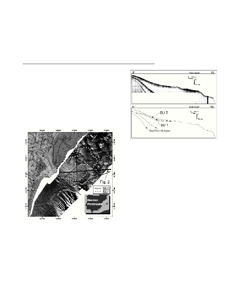
Fig. 1. Multibeam map of the study area shown the spatial distribution of
the Almanzora river fan. SU1 distribution is represents in hard line and
SU2 distribution in dotted line.
Other important characteristic is the presence of canyon heads near
(<3000 m) of the coast. These channels play an important role in the
transport of the sediment from the continental shelf to deep basin.
Besides, these morphologic elements condition the spatial distribution
of the prodelta. So, the prodelta has a greater development in the north
part where do not exist the canyons.
The seismic stratigraphy analysis of the prodeltaic deposits
evidence that surficial spatial distribution deduced of the multibeam
data is not completely correct. So, this analysis shows that the
Almanzora prodelta is wedge-shaped and extends about 5500 m
along-shelf. The thickness exceeds 12 ms TWTT in the proximal and
central areas and then gradually decreases in the northeastern and
seaward direction.
Two distinct seismic units have been identified: SU1 and SU2.
These units are located above a high amplitude seismic discontinuity
(Fig. 2).
Fig. 2. Uninterpreted (above) and interpreted (below) seismic profile of the
Almanzora prodelta. The prodelta is composed of two units: SU1 and SU2.
Seismic Unit 1 is a sheet shape, with average thickness values 4 ms
TWTT. It displays a transparent acoustic response and extends from
the mouth of Almanzora river to 5000 m in the northeastern direction.
The upper boundary of this seismic unit is the present sea?oor where
it is not overlain by the shallowest seismic unit 2.
Seismic Unit 2 is a wedge-shaped unit, which displays a chaotic
configuration and re?ective pattern. This unit overlay the Seismic
Unit1. The re?ection terminations are a downlap on the lower
boundary. The upper limit is the present-day sea?oor. Its average
thickness value is 8 ms TWTT. This has smaller spatial distribution
than SU1 and extends in NW-SE and W-E directions. The limits of the
its spatial extension fit with the limits come to multibeam data.
The SU1 characteristics (transparent seismic facies, constant and
moderate thickness through the entire distribution area and sheet sha-
pe) suggest that it is composed of fine sediments which escaped from
the nearshore and also that it was deposited when sea level was trans-
gressing and/or in a highstand position (3). In contrast, SU2 can be
included in a reggresive and/or lowstand conditions. Somoza et al.(4)
described that short cool/humid events should produce a sea-level fall
and an increase in sediment supply by increasing precipitation within
the Ebro drainage basin. So, SU2 would has been deposited under
these conditions which explain its re?ective and chaotic configuration.
Finally, the existence of delta lobe switching processes seems to be
determined by the control of the sea-level cycles.
References
1-Ferre Bueno E., 1979. El valle del Río Almanzora: estudio geográfico.
Excma. Diputación Provincial de Almería y Caja Rural Provincial de Almería.
2-Goy J.L. and Zazo, C., 1986. Synthesis of the Quaternary in the
Almería littoral neotectonics activity and its morphologic features, eastern
Betic, Spain. Tectonophysics, 10: 259-270.
3-Fernández-Salas L.M., Lobo F.J., Hernández-Molina, F.J., Somoza L.,
Rodero J., Díaz del Río, V. and Maldonado, A., 2003. High-resolution
architecture of late Holocene highstand prodeltaic deposits from southern
Spain: the imprint of high-frequency climatic and relative sea-level
changes. Contin. Shelf Research, 23: 1037-1054.
4-Somoza L., Barnolas A., Arasa A., Maestro A. Rees J.G. and
Hernández-Molina F.J., 1998. Architectural stacking patterns of the Ebro
delta controlled by Holocene high-frequency eustatic ?uctuations, delta-
lobe switching and subsidence processes. Sedim. Geol., 117: 11-32.