Rapp. Comm. int. Mer Médit., 37,2004
31
RECENT EVOLUTION OF GULLIES AND CHANNELS IN THE NE ALBORAN SLOPE
García M.
(1) *
, Alonso B.
(1)
, Ercilla G.
(1)
, Estrada F.
(1)
and Grŕcia E.
(2)
(1)
Instituto de Ciencias del Mar. CSIC. Paseo Marítimo de la Barceloneta, 37-49 08003 Barcelona, Spain - * mgarcia@icm.csic.es
(2)
Unidad de Tecnología Marina. CSIC. Paseo Marítimo de la Barceloneta, 37- 49 08003 Barcelona, Spain
Abstract
A complex system of valleys covers more than 300 km
2
at the Almeria Canyon western margin (300-1250 m deep). At least sixteen leveed
channels and six gullies form a dendritic pattern convergent to the canyon. High-resolution seismic profiles show the alternance of seismic
facies related to high- and low-energy sedimentary regimes, indicating a cyclic pattern in the recent evolution. Valleys develop during high-
energy regimes, when the downslope gravity-?ows produce overbank deposits in channel levees and erosion in gullies. Structural features,
sea-level changes and variations in the slope gradient seem to have conditioned the spatial and temporal changes in valleys characteristics.
Keywords: Alboran Sea; Gullies; Channels; Turbidite Systems.
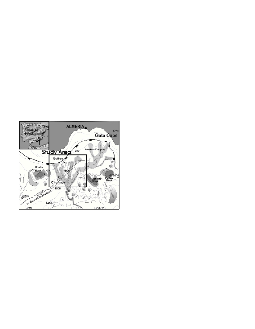
The Almeria Margin (NE Alboran Sea) is a complex geologic area
where the morphology is controlled by tectonism, volcanism and
depositional-erosive processes (Fig. 1). The main morphosedimentary
feature in this area is the Almeria Turbidite System, formed by the
Almeria Canyon and Channel, overbank deposits and lobe depo-
sits(1). High resolution seismic profiles (TOPAS) and multi-beam
bathymetric information off the NE Alboran Sea (Almeria Margin)
obtained during the HITS cruise (2) reveal the existence of a complex
pattern of valleys that cover more than 300 km
2
at the west margin of
the Almeria Canyon (water depths between 300 and 1250m).
The studied valleys can be grouped in two types -channels and gul-
lies- according to their size, morphology and seismic imprint. Sixteen
channelshave been identified. They are leveed channels with channel
infilling and typical U-shaped cross-sections. Channels have lengths
of 2.5-22 km, widths of 0.3-1 km and relieves smaller than 15 m. In
contrast, the six gullieslack present-day depositional features and are
shorter and deeper than channels, with lengths minor than 12 km, and
relief up to 40 m. Their widths range between 0.5 and 1 km, and the
cross-sections are V-shaped. Channels and gullies have general N-S to
NNW-SSE directions, perpendicular to the regional slope gradient.
They have low sinuosity, except in the areas affected by La Serrata
Fault (NE-SW direction) where axes display sharp changes in direc-
tion and gradient.
Channels and gullies spatial distribution is complex. Channels
display a convergent hierarchical pattern, where shorter channels
merge with larger ones that ?ow into the Almeria Canyon at depths
between 1100 and 1250 m. Three gullies locate in the middle of the
area occupied by channels and form part of the same hierarchical
pattern, as they converge into one of the main channels at 600 m deep.
Another three gullies locate at the eastern area, and ?ow directly into
the canyon, at 765, 910 and 960 m deep. Valleys also present
downslope variations in their characteristics. Three valleys can be
classified as channels along their itinerary, except in an area located at
the SE side of La Serrata Fault, between 650 and 950 m deep, where
they display the morphologic and seismic characteristics of gullies.
The seismic stratigraphy of the area where channels and gullies
develop comprises at least four seismic units defined by distinct
seismic facies. The lateral continuity of the facies is interrupted by the
incision of gullies and channel-fill and overbank deposits. These
facies are, from older to younger: (1) parallel stratified unit formed by
re?ections of medium to high re?ectivity in gullies and inter-valleys
areas that laterally becomes chaotic near the channels; (2) A
transparent facies unit that displays a layered sheet geometry; (3)
High re?ectivity facies unit, parallel-stratified in intervalley areas and
chaotic near channels; and (4) Transparent to semi-transparent facies
draping the whole area, including gullies and leveed channels.
The recent evolution of the system can be inferred from the
sedimentary record. Seismic units 1 and 3, with high-acoustic ampli-
tude and development of levees in the margins of the channels would
be related to high-energy regimes, when the gravity-?ows produce
overbank deposits. In contrast, homogeneous seismic units 2 and 4
may be deposited by a low-energy sedimentary regime, when pelagic
or hemi-pelagic deposition dominates the whole area. The alternance
of high and low-energy periods indicates a cyclic pattern of valleys
growth.
Channels and gullies characteristics and spatial distribution should
be related to changes in the local sediment transport from gravity
?ows. The properties of the gravity ?ows vary downslope, across-
slope and with time, conditioning the presence or absence of the
overbank ?ows, and so the development of channels or gullies
respectively. Structural features, sealevel changes and variations in the
regional slope gradient seem to have conditioned the downslope
changes of channels and gullies characteristics. The presence of a thin
semitransparent layer over the whole system suggests that channels
and gullies may have been inactive during recent times.
References
(1)-Estrada, F., Ercilla, G. and Alonso, B. 1997. Pliocene-Quaternary
tectonic-sedimentary evoluciton of the NE Alboran Sea (SW
Mediterranean Sea). Tectonophysics,282: 423-442.
(2)-Grŕcia, E. and HITS cruise party, 2001. HITSCruise Report on board
BIO Hesperides. High resolution Imaging of Tsunamigenic Structures of
the Southern Iberian Margins (HITS- REN 2000-2150E and EASSIII
HPR1-CT99-0047). 187 p.
This work was supported by the project REN2001-3868-C03-03 (MARSIBAL)