STRUCTURE OF THE ANAXIMANDER MOUNTAINS WITH THE SYSTEM
OF THE EASTERN MEDITERRANEAN
Tolga Gönenç
1
, Mustafa Ergün
2*
and Ersel Zafer Oral
1
1
Dokuz Eylül University, Buca-Izmir, Turkey
2
Yasar University, Alsancak, Izmir, Turkey - * mustafa.ergun@yasar.edu.tr
Abstract
Anaximander Montains are a foundered part of the southern Turkish microplate (except the eastern mountains). The hypothesized
foundering must be related to transpressive wrench tectonics from the Strabo Transform zone, compression across the Florence Rise, and
the extension between the Turkish and Aegean microplates. The Anaximander Mountains form a group of topographically promeninent
features rising more than 2 km above the surrounding sea?oor.
Key Words: Foundering, Anaximander Mountains, Mud volcanoes.
Rapp. Comm. int. Mer Médit., 37,2004
33
Introduction
Neotectonics of the eastern Mediterranean is controlled by the
reciprocal affects of the Eurasia, Africa and Arab plates and the other
small plates and blocks. The tectonic situation in the northern eastern
Mediterranean region is dominated by the interaction between the
African plate and Eurasian plate (here it is represented by the Aegean
and Anatolian plates). The African plate currently moves north-north-
eastwards and north-eastwards relative to the Aegean and Anatolian
microplates, respectively. The boundary between these microplates
and Africa is delineated by the Hellenic Arc and the Pliny/Strabo
Trench in the west and the Cyprus Arc and diffuse fault system in the
east. Only the Hellenic appears to be an active subduction zone. Both
the Pliny/Strabo Trench system and the East Anatolian Fault Zone are
sub-parallel to the relative plate motion vector and hence are domi-
nated by transform motion. The region between the west of Cyprus
and the East Anatolian Fault Zone is less seismic than both the Hel-
lenic Arc in the west and the East Anatolian Fault system in the
northeast. The seismicity is particularly low between Pliny/Strabo
Trench and Cyprus.
General Morphology and the Structure of the Anaximander
Mountains and the Surroundings
The Anaximander Mountains are under compressional regime of
the junction of the Hellenic and Cyprus Arcs. These mountains are
made of three principal highs (1) which are separated from each other
with faults and undergoing independent deformations. There are
variations and unconformities on the strikes and dips of the faults and
folds in the region which mean that those structures have been formed
by the forces from different directions, and accordingly it could be
said that the area has been affected by several deformations at
different times. To the north, the mountains are bordered by a chain of
relatively small but deep basins which are, from west to east, the
Rhodes Basin (more than 4 km deep), the Finike Basin (3 km deep),
and the Antalya Basin (about 2.5 km). The eastern continuation of the
Strabo Trench, which is poorly expressed in the form of several
shallow and gentle sea?oor depressions, separates the Anaximander
Mountains from the eastern termination of the Mediterranean Ridge
and from the Florence Rise (Fig. 1).
The western and southern mountains, and probably the Beydaglar
are, although they are spatially widely separated, they seem to be the
same morphologically and geologically. The Rhodes and Finike
basins indicate rifting in the region. The Finike Basin which was
formed by rifting due to the tensional tectonics of the Beydaglar block
in the north (Fig. 2) is filled by thick sedimentary sequence over
which the sediments, derived from the area between the southern and
western mountains, have pushed basinwise over the southern side.
However, the eastern mountain which is separated from the
southern mountain with gentle relief of fold belt is quite from the
other two mountains tectonically and morphologically and it has been
affected from the other two mountains tectonically and
morphologically and it has been affected by different tectonism and
geological evolution. Mud volcanoes which are probably formed
under compressional tectonics are distributed randomly over the
eastern mountains. Also the cobblestone structures which were
observed at the boundary of the eastern mountains and the Antalya
Basin are the result of compressional tectonics. There is no evidence
for any typical subduction along the Florence Rise which is a
submarine feature extending from Cyprus in the southeast to the
Anaximander Mountains. This arcuate structure is considered to act as
the present boundary between the African and Anatolian-Aegean
plates (2).
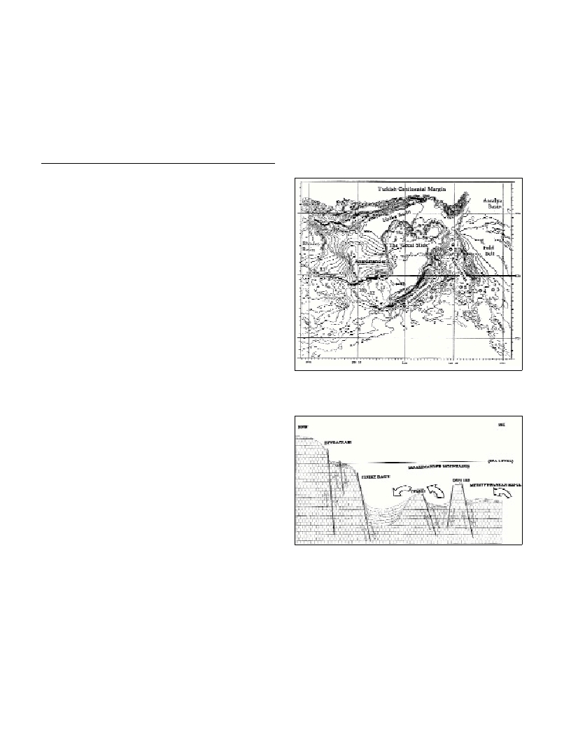
Fig. 1. Bathymetry map of Anaximander Mountains at 100 m contour
interval showing locations of principal features. Numbers 1 to 7 are the
mud volcanoes. The rest are the other features.
Fig. 2. The schematic NNW-SSE cross section indicating structural tec-
tonic elements between the Beydaglar (SW Turkey), the Finike Basin, the
Western and Southern Mountains.
References
1-Woodside, J.M., 1995. ANAXIPROBE-95 Report of the l’Atalante
Expedition, 4-11 August 1995, Heraklion, Crete to Port Said, Egypt,
Amsterdam, Vrije Universiteit (unpublished cruise report).
2-Woodside, J.M., Mascle, J., Zitter, T.A.C., Limonov, A.F., Ergün, M.,
and Volkonskaia, A., 2002. The Florence Rise, the Western Bend of
Cyprus Arc. Marine Geology, 185: 177-194.