HIGH-RESOLUTION IMAGING OF THE CARBONERAS FAULT ZONE ON THE ALMERIA MARGIN
(NE ALBORAN SEA): PALEOSEISMIC IMPLICATIONS
Eulŕlia Grŕcia
(1)*
, Juan Ignacio Soto
(2)
, Miquel Angel Marín
(1)
, Alexis Vizcaíno
(1)
and HITS cruise party
(1)
UTM-CSIC, Centre Mediterrani d’Investigacions Marines i Ambientals (CMIMA), Barcelona, Spain - *egracia@utm.csic.es,
miki@utm.csic.es, alexis@utm.csic.es
(2)
Instituto Andaluz de Ciencias de la Tierra (CSIC-UGR), Campus Fuentenueva, Granada, Spain (jisoto@ugr.es)
HITS cruise party: P. Blondel, P. Terrinha, M. Farrán, R. Bartolomé, L. Bullock, M. Gómez, O. Gómez-Sichi, J. Gonçalves, C. Jacobs,
G. Lastras, H. Perea, M.J. Román, C. Roque, V. Wilmott
Abstract
The South Iberian Margin is located at the convergence of the European and African plates, where large magnitude earthquakes in Western
Europe take place. Based on data from Spanish and European programs, we identified several active structures which are potential sources
of large magnitude earthquakes and tsunamis (Mw > 6) (1). We plan to undertake a paleoseismological onshore-offshore integrated study
of the Carboneras Fault (Almería Margin). This is the best approach to accurately determine the past activity and seismic parameters of
active faults (geometry, slip rate, maximum event magnitude, recurrence interval and time elapsed since the last earthquake). These
parameters are of paramount importance to assess seismic hazard models in the Iberian Peninsula, especially when considering large
magnitude earthquakes and long recurrence intervals (10
3
-10
4
years).
Keywords: TOBI sidescan sonar, active faulting, turbidite system, Western Mediterranean
Rapp. Comm. int. Mer Médit., 37,2004
35
The continental margin south of Almeria, located at the NE part of
the Alboran Sea (Western Mediterranean), is a complex and active
area characterized by recent swarms of superficial earthquakes with
magnitudes ranging from M
w
5.1 and 4.7 (2). With the main objective
of identifying active structures potentially generators of earthquakes,
we recently surveyed this area in the frame of the HITS project (3).
During the HITS cruise carried out onboard the BIO Hesperidesin
September 2001, a multidisciplinary dataset comprising high-
resolution (6 m) TOBI sidescan sonar from the Southampton
Oceanography Centre (UK), Simrad EM12S swath bathymetry and
backscatter, TOPAS sub-bottom profiler, and gravity data were
acquired. This high-resolution dataset, exhibiting a range of acoustic
facies, fully covers an area of approximately 33.3 x 100 km in water
depths ranging from 80 m to 1700 m, and provides new insights into
the control of neotectonic structure on the Plio-Quaternary
sedimentary architecture of the Almeria turbidite system.
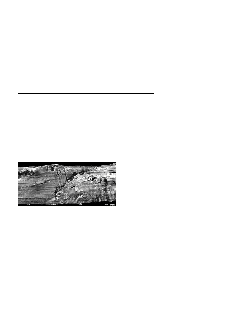
Fig. 1. Bathymetry superimposed on the high resolution TOBI sidescan
sonar mosaic of the SE Spanish Margin, where we can easily identify the
submarine prolongation of the left-lateral Carboneras Fault, tributary
channels and Almeria Canyon and turbidite system.
The Almeria Canyon is a meandering channel system (4) showing
steep slopes over most of its course (up to 17%), and confined
between the Cabo de Gata Spur, Chella and El Sabinar Banks carbo-
nate platforms, imaged as high-re?ectivity areas in the TOBI mosaics.
North of 36ş26’N, the upper to middle part of the canyon parallels the
submarine continuation of the Carboneras Fault Zone, following a
N47 trend, whereas south of it, the canyon meanders downslope with
a net N-S trend. At latitude 36ş26’N, the 60 km long left-lateral
Carboneras Fault shows a positive topography on the sea?oor which
suggesting a transpressional ?ower-structure, and offsets (about 2.5
km) into two segments: a northern N47-trending segment and a
southern N60 trending segment. The fault also modifies locally the
trend of tens of sub-rectilinear highly incised gullies and channels
which converge feeding into the Almeria Canyon. Slope instability
features and mass wasting deposits (headscarps, detached blocks and
debris ?ows) are commonly observed on the ?anks of the banks and
especially south of the El Sabinar Bank. They might be associated
with the seismic activity taking place along this margin.
The assessment of seismic risk in the region is largely based on
the relatively short period of instrumentally recorded earthquakes
(e.g.,5). Forthcoming work, in the frame of the National project
IMPULS and ESF-Eurocores EuroMargins WESTMED project, will
be based on onshore-offshore paleoseismic analysis and sedimentary
record preserved in deep-sea cores, devoted to determining the past
activity of the faults along the south Iberian Margin and to calculating
their slip and recurrence rate.
Acknowledgement :The authors are grateful for funding from
MCYT Acción Especial HITS (REN2000-2150-E), European
Commission EASSS-III programme (HPRI-CT99-0047), and Spanish
national project IMPULS (REN2003-05996MAR). We thank the
captain and crew on board the R/V Hesperides, and particularly the
UTM-CSIC technical staff and TOBI Team from the Southampton
Oceanography Centre (UK) for their assistance throughout the data
collection.
References
1-Grŕcia, E., Dańobeitia, J.J., Vergés, J., and PARSIFAL Team, 2003.
Mapping active faults offshore Portugal (36şN-38şN): Implications for
seismic hazard assessment in the southwest Iberian Margin. Geology, 31
(1): 83-86.
2-Stich, D., Ammon, C.J., Morales, J., 2003. Moment tensor solutions for
small and moderate earthquakes in the Ibero-Maghreb region. J. Geophys.
Res.,108, B3: 2148-2168.
3-Grŕcia, E., Dańobeitia, J.J., and HITS cruise party, 2001. High
resolution mapping of Tsunamigenic Structures in the SW Iberian Margin:
Implications for earthquake hazard assessment. EOS (Trans., AGU), v.
120: 1024.
4-Cronin, B.T:, Kenyon, N.H., Woodside, J., den Bezemer, T., van der
Wal, A., Millington, J., Ivanov, M.K., Limonov, A., 1995. The Almeria
Canyon: a meandering channel system on an active margin, Alboran Sea,
western Mediterranean. Pp. 84-88. In:K.T. Pickering, R.N. Hiscott, N.H.
Kenyon, F. Ricci Lucci, and R.D.A. Smith (eds.), Atlas of deep water
environments: Architectural style in turbidite systems.Chapman & Hall.,
London.
5-IGN, 1999. Boletín de sismos próximos 1999: Publicaciones del
Instituto Geográfico Nacional, Madrid, Spain.