NATURE AND ORIGIN OF SMALL MUD DOMES FROM THE CENTRAL SOUTHERN
MEDITERRANEAN RIDGE (EASTERM MEDITERRANEAN SEA)
C. Huguen
*
, J. Mascle and the NAUTINIL Scientific Party
UMR 6526 Geosciences Azur, B.P. 48, 06235 Villefranche sur mer, France
Abstract
Swath mapping, (P
RISMED
2 survey) over the Mediterranean Ridge, have revealed, north of the libyan promontory, the presence of
numerous small dome-shaped features delineating a NW-SE, 80 km long, belt. The morphology and backscatter characteristics of some
of these features have been precised by near bottom side scan sonar. These structures were interpreted as mud volcanoes or mud diapirs
[1]. During the recent NAUTINIL survey (Sept. 2003), one dive has been made, on one of theses domes (“Lorient” dome), to determine
the nature of these enigmatic reliefs and provide constraints on their geology and type of emplacement.
Key-Words: Mud Diapirs, Deep dives, Central Mediterranean Ridge, Eastern Mediterranean.
Rapp. Comm. int. Mer Médit., 37,2004
37
Regional swath bathymetric and backscatter data from PRISMED
II survey have shown the presence, within the inner Central
Mediterranean Ridge, north of the Libyan promontory, of tens of
small sub-circular domes delineating a NW-SE arcuate belt at about
50-60 km south of Olimpi Mud volcano field [1, 2]. Side scan sonar
and sub bottom profiles from MEDINETH survey over one of theses
features (Lorient dome) have provided details on their morphological
and acoustic characteristics (Fig. 1). “Lorient” mud dome is a
relatively steep, elevated (up to 200 m), and irregular relief
characterized by an acoustic signature which does not support
significant recent mud ?ows. Only restricted areas, with weak to
intermediate backscatter strengths (Fig. 1) and chie?y seen at the base
of the feature are suggestive of mud out?ows; high backscatter
patches (Fig. 1), could be interpreted as evidences of probable debris
?ows. One characteristic, well evidenced on the side scan sonar data
(Fig. 1), is the presence of sets of lineaments which explain that the
domes do not appear on near bottom plan views as sub-circular
features but rather as angular reliefs. The main, N70 and N145,
oriented lineaments, also expressed as vertical offsets on sub bottom
profiles, are interpreted as R (N70), R’(N145) Riedel secondary faults
generated along regional strike slip faults as determined from surface
geophysical data.
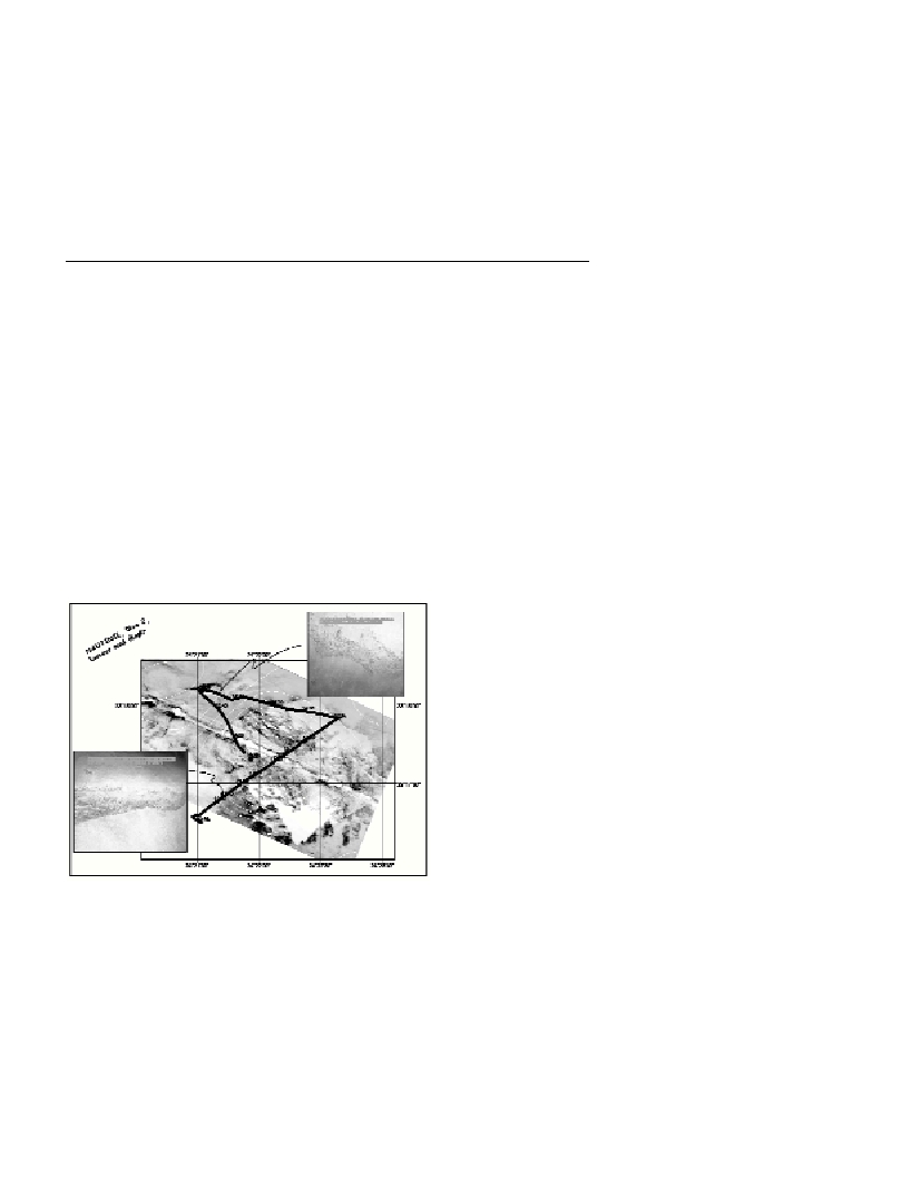
Fig. 1. Side scan sonar data over the “Lorient” mud diapir. The dive track
is located as well as two sea?oor pictures over the southern slope and
the northern surroundings of the structure.
The objective of the Nautile dive, made on “Lorient dome” during
the recent NAUTINIL cruise was, through direct seafloor
observations, to collect informations on the nature and origin of this
feature, in order to compare it to the well known Olimpi field mud
volcanoes which lies at about 50 km north of this belt [1].
No mud ?ows nor specific ?uid venting, authigenic carbonate
pavements , or biologic communities, all characters typical of active
mud volcanoes [3] were observed. “Lorient” dome is characterized by
strong slope sedimentary unstabilities, especially along its southern
border (Fig. 1). Several observations, such as the existence of
numerous N60 trending metric/decametric scarps, a recent fault plane
(showing sliken slides) support a tectonic control for the emplacement
of the structure whose, moreover, displays near its top numerous
anastomosed open fractures similar to fractures commonly seen on
salt diapir caprock covers
All available data (geophysical and in situ observations), support
that the feature results from diapiric emplacement mechanisms rather
than from mud extrusion processes. This suggests that the Southern
Belt is made of a series of mud diapirs emplaced through recent to
active regional fractures cutting across the cover of the Mediterranean
Ridge and therefore proceeds from different mud levels and different
expulsion mechanisms than the active mud volcanoes from the Olimpi
field.
References
(1)-Huguen, C. 2001. Déformation récente ŕ actuelle et argilo-cinčse
associče au sein de la Ride Méditerranéenne (Méditerranée Orientale).
Thčse de Doctorat, Université Paris VI.
(2)-Mascle J., Huguen C., Benkhelil J., Chamot-Rooke N., Chaumillon
E., Foucher J.P., Griboulard R., Kopf A., Lamarche G., Volkonskia A.,
Woodside J. and T. Zitter, 1999. Images may show start of European-
African plate collision. E.O.S. 80: 421, 425, 428.
(3)-MEDINAUT/MEDINETH Shipboard Scientific Parties, 2000.
Linking Mediterranean brine pools and mud volcanism. EOS,
Transactions, American Geophysical Union, 81(51): 625, 631-633.