SWATH MAPPING SYNTHESES OF DEEP MEDITERRANEAN SEA BASINS: A PARTNERSHIP BETWEEN
SEVERAL NATIONAL OCEANOGRAPHIC INSTITUTIONS, COORDINATED BY CIESM AND IFREMER
Benoit Loubrieu
1
and Jean Mascle
2*
1
Ifremer, Centre de Bretagne, Plouzané, France
2
Géosciences-Azur, Observatoire de Villefranche, Villefranche/Mer France
Abstract
Swath mapping of most of the deep Mediterranean Sea basins is currently progressively completed by several national
Oceanographinc/Hydrographic Institutions from Southern Europe. The CIESM Marine Geosciences Committee and Ifremer DRO
mapping office have jointly promoted and pilot compilations and publication of synthesis maps of the Eastern and Western Mediterranean
basins, These maps reveal many geological characteristics (tectonic, volcanic, sedimentologic, geochemical) imprinted on the sea ?oor.
The first map (Eastern Mediterranean), already published in 2001, is now progressively upgraded using new data sets; the second one
(Western Mediterranean) is a new synthesis based on swath data originating from Italian, Spanish and French Institutes and laboratories.
Key words: Mediterranean basins, swath bathymetry synthesis
Rapp. Comm. int. Mer Médit., 37,2004
49
Introduction
Since about 10/12 years systematic swath mapping surveys
(including bathymetry, and often acoustic bottom re?ectivity) have
been conducted in the deep Mediterranean sea, particularly in its
Eastern basins, and more recently in the Western ones. These data
have been collected for two main purposes: (a)for each country to
obtain a better knowledge of their EEZ; (b)a better understanding of
the complex and active sedimentary, geochemical, volcanic, and
tectonic processes operating concurrently in the Mediterranean
marine spaces.
These data have been systematically recorded by different national
oceanographic and hydrographic Institutions or Laboratories from
Europe (France, Greece, Italy, the Netherlands and Spain mainly)
most of the time in the framework of national programs.
In 1999 the CIESM Marine Geosciences committee has promoted
an unformal cooperation between several laboratories willing to
cooperate in producing compilations of swath data to better image, at
a basin scale, the various active processes shaping the sea?oor of the
Eastern Mediterranean Sea. Ifremer DRO mapping office has been
volunter to act as the necessary technical advisor and practical support
for these compilations. A first set of two maps (bathymetry and
acoustic imagery), at a scale of 1/1.500.000, has been produced in
2001 (1). These maps illustrate the startling changes brougth to the
knowledge and understanding of deep basins by mapping using swath
systems. They particularly reveal a completely new view (and greatly
help to a better understanding) of most of the major physiographic
features (Mediterranean ridge, Nile cone, etc.) of the deep basin.
During the last CIESM congress (Monaco, September 2001) a
round table on swath mapping of the Mediterranean sea has concluded
on the great scientific interest and necessity to: (1)promote, if
possible, a compilation, at the scale of 1/1.500.000, of available sawth
data for the Western Mediterranean Sea.; (2)up-grade, as far as
possible and using all new data made available by partners willing to
participate, the Eastern Mediterranean sea compilation.
We present here the state of the art concerning these two attempts.
Eastern Mediterranean Sea compilation(see Fig. 1)
Fig. 1.
Present
stage of the
Eastern Med
Sea multi-
beam bathy-
metric
compilation.
A detailled map of the Egyptian margin has been published in 2003
(2). Recent data recorded in 2001 and in 2003 (Fanil, Blac and
Nautinil expeditions, respectively) by different French laboratories
(Géoscience-Azur, Villefranche; Legem, Univ. Perpignan; Ifremer
DRO-GM, Brest) will be incorporated to the compilation, as well as a
few swath data, mainly from the Aegean sea, to be potentially provid-
ed by HCMR (Greece). Moreover it is hoped that complementary data
will be obtained during a new french survey already scheduled in late
2004.
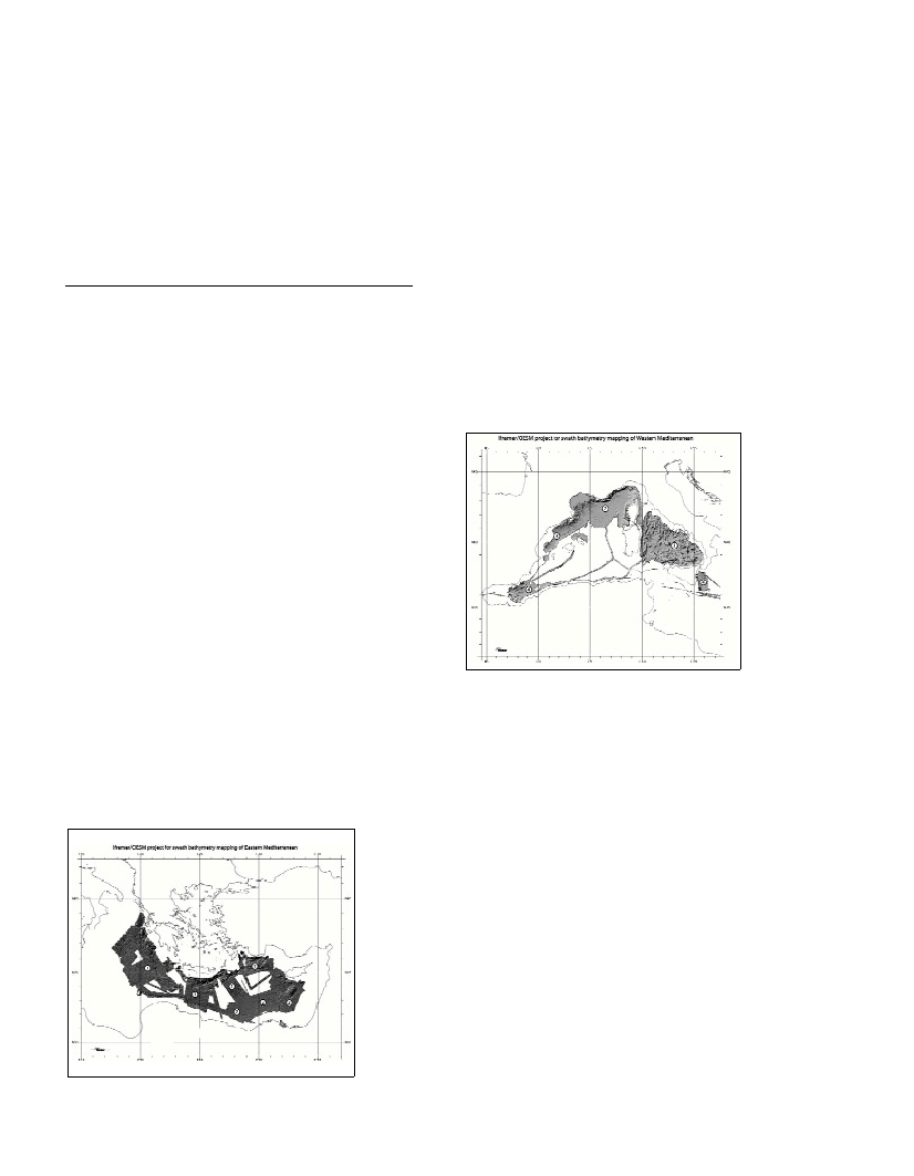
Western Mediterranean Sea compilation(see Fig. 2)
Different Institutions (ISMAR Bologna, Italy; Ifremer and IUEM,
Brest, France; IEO, Madrid, GRC, Barcelona and IACT, Granada,
Spain) have agreed to provide DTM, at a 500 m grid spacing, extract-
ed from their own swath surveys (and processing) in Western
Mediterranean sea, to Ifremer DRO-GM mapping office in charge to
construct an homogenous synthesis which will be the first multibeam
echo-sounding derived map for the Western Mediterranean Sea.
The two maps (upgraded Eastern and new Western Mediterranean),
at a scale of 1/2.000.000, should be jointly published by CIESM and
IFREMER in late 2004. It is also anticipated to publish a map of the
whole Mediterranean sea at a scale of 1/4.000.000.
These documents, the first multibeam bathymetric maps of a
complete oceanic space, will greatly improve our global knowledge of
the Meditereanean sea ?oor and of its different geological processes.
Finally we anticipate that such an open, and productive,
collaboration will progressively widen to others laboratories and
Institutions, and lead to a mapping, as complete as possible, of the
deep Mediterranean basins. We also hope that data from shallower
areas (continental shelf and uppermost slope) will soon be made
available to produce a complete picture of the Mediterranean sea and
thus provide a necessary link with the still evolving adjacent onshore
domains.
References
1-Loubrieu B., Satra C., Cagna R., 2001. Cartography by multibeam
echo-sounderof the Mediterranean Ridge and surrounding areas. 2 maps
échelle 1/1500000
čme
(Acoustic image and Morpho-bathymetry of the
Nile deep-sea Fan). éditions Ifremer/CIESM.
2-Sardou O., J. Mascle, 2003. Cartography by multibeam echo-
sounderof the Nile seep-sea Fan and surrounding areas. 2 maps échelle
1/600000
čme
(acoustic image and Morpho-bathymetry of the Nile deep-
sea Fan). Géosciences Azur/ CIESMSpecial Publication.
Fig. 2.
Present stage
of the Western
Med Sea
multibeam
bathymetric
compilation.