USE OF MULTIBEAM ECHOSOUNDER TO DETECT TERRAIN CHANGES
A ROUND TWO ARTIFICIAL REEFS (WESTERN ADRIATIC SEA, ITALY)
Sarine Manoukian
*
, Gianna Fabi and Alessandra Spagnolo
Istituto di Scienze Marine ISMAR-CNR, Sezione Pesca Marittima, Ancona, Italy - * s.manoukian@ismar.cnr.it
Abstract
Since the end of eighties, Senigallia and Portonovo, on the Western Adriatic Sea, host two artificial reefs at a depth of about 10 m. After
about sixteen years from their construction, they were monitored through a multibeam echosounder to assess sea-bottom morphology and
terrain changes around the structures. The bathymetric system was proved a very advanced geophysical instrument able to detect the
distribution of artificial reefs and the location of every single unit. 3-D visualizations of the study areas showed clearly movements of the
single units and subsidence of the reefs, above all the central zone.
Key-words: multibeam echosounder, artificial reefs, sea-bottom, Adriatic Sea
Rapp. Comm. int. Mer Médit., 37,2004
52
Introduction
During the last thirty years, fourteen artificial reefs were built-up
along the Western Adriatic coast at a depth ranging from 11 to 15
meters. In the present work the artificial structures of Senigallia and
Portonovo were considered after about sixteen years from their
construction to observe how they altered in the time, as well as the
effects on sea-bottom morphology due to the whole reef and on terrain
changes around individual reef units. High-resolution seabed maps of
artificial reefs created with data from a multibeam echosounder
(MBES) were previously performed in Taiwan in 1998 (1;2).
Materials and Methods
Senigallia reef was built-up at 12 m depth, about 1.2 nm offshore,
on a sandy-muddy seabed far from natural hard substrates. The reef
was constructed in 1987 and consists of 29 pyramids, each made of
five 2-m cubic concrete blocks, and twelve concrete cages (6x4x5 m)
for shellfish culture placed in a rectangular arrangement. Portonovo
reef was deployed in 1988 in Portonovo Bay (Conero Promontory),
0.5 nm offshore on sandy bottom at 12 m depth. It consists of 87
pyramids and 36 cages arranged in three oasis of the same type as
Senigallia reef and 100 m far from each other. The main difference
between the two reefs is their geographical position: Senigallia reef is
an open area, exposed to winds between NW-SE and currents that run
parallel to the shoreline in the same direction, while the Portonovo
reef is more protected from winds and currents due to the indented
coastline of the promontory.
In 2002 the two artificial reefs were investigated through the
Kongsberg-Simrad MBES EM-3000 system to evaluate terrain
changes around the structures. The system mounted on research vessel
M/N Tecnopesca IIbelonging to ISMAR–CNR of Ancona, meets all
standards suggested by International Hydrographic Organization (3).
EM-3000 operated at a frequency of 300 kHz, with an angle of 120°
along six survey lines at a distance of 30 m from each other. To obtain
detailed depth information the vessel speed was 3-6 knots.
Recorded data were processed using Simrad Neptune and Roxar C-
Floor software. The first one allowed applying the post-processing
steps: the “cleaning” of the navigation and the tidal corrections.
Processed depth soundings from EM-3000 system were available as
ASCII xyz files. Their processing using C-Floor was the next step to
obtain 3D images of the reefs.
Results and Discussion
The geometric structure of both reefs and how the terrain around
concrete blocks was changed were illustrated using sun-illuminated
option (Fig. 1). Darker areas just around the single units evidenced a
certain subsidence of the terrain, followed by lighter boundary that
represented the bank of removed substrate. These terrain movements
caused in some cases the instability of the pyramids inducing the
upper block falling.
Regarding the complete bathymetric coverage of the two artificial
reefs, it was possible to observe the sinking of the whole sea-bottom
under the structures and particularly strong subsidence in the central
zone of the areas. This vertical movement and the amount of it were
also confirmed through cross sections along the longer side of the
reefs. It was clearly evident from the profiles that the central areas
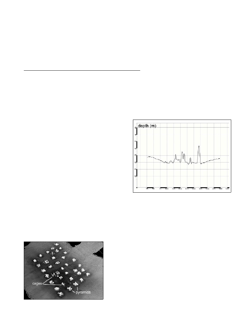
were about 1 m deeper than the surrounding terrain (Fig. 2).
Fig. 2. Profile of a cross section along the whole length of Senigallia arti-
ficial reef.
Conclusions
The results showed that EM-3000 system was an efficient
instrument not only to delimit the extension of artificial reefs but also
to identify single units and to assess their spatial movements and
subsidence. In fact, in both study areas, it allowed to point out a
scouring of some concrete blocks that composed the pyramids and
certain subsidence that occurred around the single pyramids or cages.
In addition, EM-3000 enabled also to show a subsidence in the whole
areas that hosted the artificial structures. It was likely that the close
settlement of one pyramid or cage with the other made the reef as a
single large structure that changed currents direction and wave
motion, acting in this way on the bottom and inducing this significant
alteration of the entire seabed morphology.
References
1-Shyue S., 1998. Preliminary study on the distribution of artificial reefs
by using multibeam echo sounder. Proceedings of OCEANS’98 –
IEEE/OES:1144-1148.
2-Shyue S. and Yang K., 2002. Investigating terrain changes around
artificial reefs by using the multibeam echo sounder. ICES Journal of
Marine Science, 59: S338-S342.
3-IHO Standards for Hydrographic Surveys, 1998. Special Publ., 44. 25 p.
Fig. 1. Sun-illuminated 3D image of Portonovo artificial reef.