THE LAST GLACIAL MAXIMUM (18.000 û 14.000 y. B.P.) AND ITS MICROPALEONTOLOGICAL,
PALEOGEOGRAPHIC AND PALEOCEANOGRAPHIC REGISTER IN THE BALEARIC SEA
G. Mateu
1
* J. Acosta
2
, M.J. Vi±als
3
, M. Moreiro
1
, G. Nadal
1
, G. Mateu-Vicens
1
1
Laboratori de Micropaleontologia û Edifici Guillem Colom. Universitat de les Illes Balears, Spain - * guillem.mateu@terra.es
2
Instituto Espa±ol de OceanografÝa. Dept. GeologÝa Marina , Madrid, Spain
3
Universitat PolitÞcnica de ValÞncia. Dept. IngenierÝa Cartogrßfica, Geodesia y FotogrametrÝa, Spain
Abstract
During the Last Glacial Maximum, the Emile Baudot Escarpment and the two submarine mounts, dels Oliva and AusiÓs Marc, formed a
microarchipielago between the ôPitiusaö and the ôGran Balearö. The benthic and planktonic forams of this microarchipielago sediments
are studied here. It is a relictual benthic fauna that belongs to the infra-circalittoral during the Glacial Maximum. In the Mont Oliva and
AusiÓs Marc these species represent a 25% over the total. The other 75% consists in recent planktonic fauna that fits the actual, post-
glacial, mediterranean hydrodinamics. Otherwise, in the Emile Baudot Escarpment the benthic species are predominant as it occurs in the
biofacies of the balearic infra-littoral.
Keywords: Foraminifera relicts, Last Glacial Maximum
Rapp. Comm. int. Mer MÚdit., 37,2004
57
In the oceanographic cruise Pitiusas I, on board R/V Cornide de
Saavedra,June 74, 40 samples of 25.000 benthic and planktonic
foraminifera were collected together with geomagnetic study of the
submarine mounts of the Balearic Sea.
In 1999 on board R/V HespÚridesthe geologists of the Spanish
Oceanographic Institute began a very good cartography (M14) which
digital model has permitted the visualisation of the Balearic
paleogeography of the last glaciation (18.000 û 14.000 year B.P.),
when the sea level lowered around 130 m and the three mounts, now
submerged 90 m deep, formed the archipielago called ôBanc del
FrancÞsö between the SW of the ôGran Balearö and the E of the
Pitiusa, the only two great islands then in the Balearic Sea. (1,2,3)
The ômodernö planktonic species which re?ect the ôIberian gyreö
and the relict benthic ones of the Last Glacial Maximum when the
ôBanc del FrancÞsö was an archipielago with Mont dels Oliva and
Mont Ausias Marc surrounded by Posidoniameadows and algae
which relict infralittoral benthic foraminifera now are part of the
postglacial pelagic sedimentation.
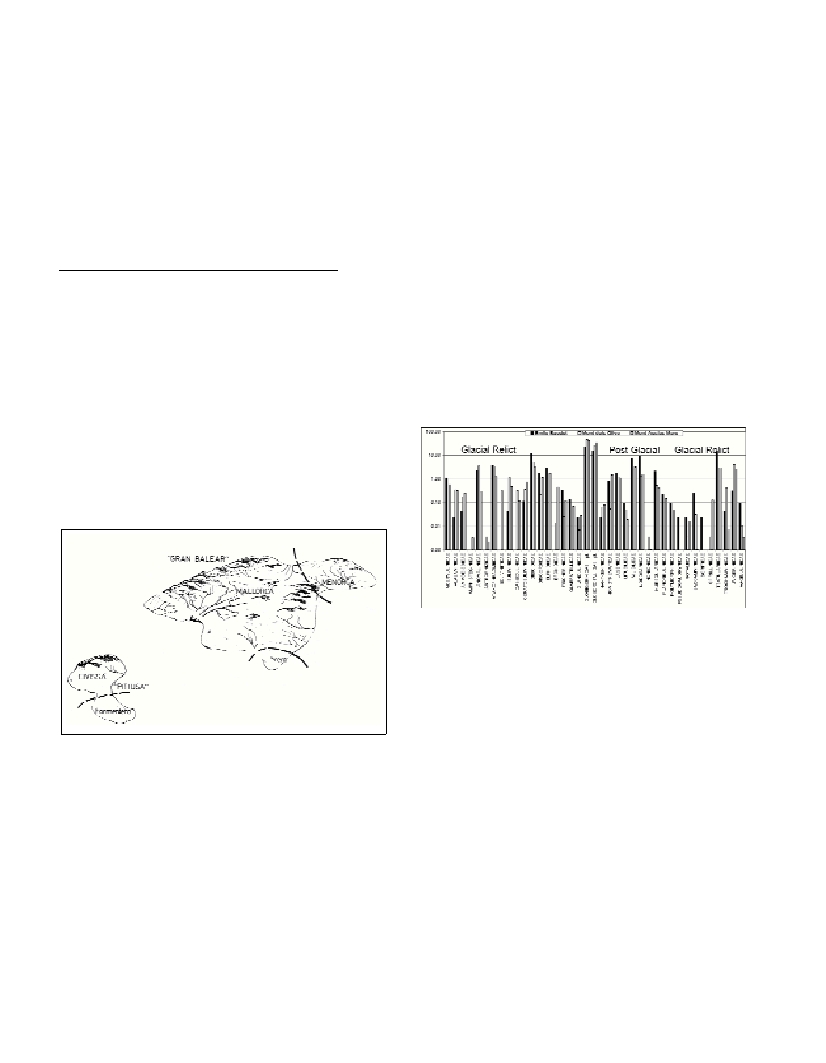
Fig. 1. The Balearic Islands in the Last Glacial Maximum.
In the present work we give some conclusions with the possible
discussion of the data of which we can outline the following points:
1.- The present biofacies of the submerged islands between Eivissa
and Mallorca are mostly consisting of glacier relict benthic
foraminifera, of the old infralittoral ecosystem of the L.G.M. and of a
75% of postglaciar, atlantic-mediterranean, modern planktonic
foraminifera, typical of the ôIberian Gyreö.
2.- The taphocenosis is represented by 39 families, and 354 species,
the biodiversity of which, correspond in great mesure, to the glacier
climate of when the Emile Baudot, Mont dels Oliva and Mont Ausias
Marc were islands, with a maximum length and width 5x1Æ5, 3x2 and
4Æ5x2 miles respectively (1,3). This microfauna original from old
algal, Posidonia and psammic assemblages formed by Cibicididae,
Homotrematidae, Hauerinidae (Miliolidae) and Soritidaeand a part
of the present hemipelagic Balearic Sea sediments (Globorotalia
in?ata, Globorotalia truncatulinoides, Orbulina universa, etc.).
3.- Comparing the biofacies of the 3 submerged mounts with the
ones of Menorca and Cabrera channels, the psammic, epiphytic,
oligobatimetric affinity of the microfauna can be observed. The
hemipelagic character of the biofacies of the three submerged mounts
can be seen in a 75% of planktonic forms in Mont dels Oliva and
Mont Ausias Marc and in a smaller percentage in Emile Baudot. All
in convergence with the mesoatlantic and northmediterranean water
masses of the ôIberian Gyreö around Balearic Islands. In the Menorca
and Cabrera channels there is a dominance of algal and posidonic
species, with some presence of paralic lagoon species and an
infralittoral holocenic consolidation specially after the Flandrien
Transgression (7.000 û 6.000 y.B.P.). (4)
Fig. 2. Glacial and Post Glacial Foraminifera.
References
1-Acosta J., Canals M., L¾pez-Martinez J., Mu±oz A., Herranz P.,
Urgeles R. Palomo C., Casamor J.L., 2002. The Balearic Promontory
geomorphology (western Mediterranean): morphostructure and active
processes. Geomorphology,49 (2002): 177-204.
2-Mateu G., Rey J., DÝaz del RÝo V., 1985. Les paleolits de la Baie de
PÔlma de Mallorca. Interpretation sismique et datation biochronologique.
Rapp. Comm. Int. MerMÚdit., 29(2): 43-53.
3-Palomo C., de Miguel J., Acosta J., Sanz J.L., Herranz P., 1974. Estudio
geomagnÚtico de tres montes submarinos en el Mar Balear. 1¬ Asamblea
Nacional de Geodesia y GeofÝsica, Madrid V. II, pp. 895-923.
4-Mateu G., Vi±als M.J., Moreiro M., Nadal G., 2001. La Transgresi¾n
Flandriense a travÚs de los ForaminÝferos bent¾nicos del Mar Balear. In:
Pons G. y Guijarro J.A. (ed.). El canvi climÓtic. Soc. H¬ Nat. Balears.
Monografia 9.