NEW INSIGHTS ON THE KOS-NISYROS VOLCANIC FIELD
FROM THE MORPHOTECTONIC ANALYSIS OF THE SWATH BATHYMETRIC MAP
Nomikou P.
1*
, Papanikolaou D.
1
, Alexandri S.
2
, Ballas D.
2
1
Dept. of Geology, University of Athens, Greece,
2
Hellenic Centre for Marine Research, Athens, Greece - * evi@ncmr.gr
Abstract
The recent volcanic activity at the eastern edge of the Aegean volcanic arc is limited within a neotectonic graben structure which is
developed in an E-W general direction, between the alpine basement of Kos Island to the north and the alpine basement of Tilos Island to
the south. In between the major boundary faults of the neotectonic graben there is an extended volcanic area comprising several individual
volcanic centers. The detailed bathymetric map, constructed by recently acquired high resolution multibeam data permitted the distinction
of the main morphotectonic structure of the area comprising a number of basins with average bottom depth of ñ600m in between several
volcanic centers separated by minor active faults.
Keywords: swath mapping, volcanic centers, Aegean Sea, tectonics
Rapp. Comm. int. Mer MÈdit., 37,2004
60
Geodynamic setting
The eastern sector of the Aegean volcanic arc, including the islands
of Kos, Nisyros and associated islets, is the result of northeastward-
directed subduction of the Eastern Mediterranean lithosphere below
the active Hellenic margin of the European plate. It is geodynamically
very active since it comprises large volumes of volcanic products
within Late Pleistocene-Holocene. Major magmatic activity began at
least 160 Ka ago producing the largest eruption in the Eastern
Mediterranean manifested by the ìKos ignibriteî which covered an
area of more than 3000 Km
2
. The centre of this eruption is not known
with accuracy but it is probably located in the submarine area north of
Yali islet. This major caldera structure has been obscured by the
younger volcanic activity and eversince several volcanic structures
have been developed in the area.
Swath bathymetry
The offshore studies in the area of Nisyros-Kos islands comprise
detailed multibeam bathymetric mapping carried out onboard R/V
Aegaeo in three successive cruises during 2000, in the framework of
the EC project Geowarn (IST 1999 123210). The SEABEAM 1180
(180 kHz) system was used, for depths <500m and the SEABEAM
2120 (20 kHz) system, for depths >500m. Operating the systems for
totally 12 days with an average speed of 5 and 10 knots respectively,
3.500 Km
2
were covered from very shallow depths to great depths of
2200m. After elaborating data processing, the swath bathymetric map
of Kos-Nisyros volcanic field has been created with 50m grid interval
using 10m isobaths at scale 1/100.000, georeferenced to a WGS-84
ellipsoid and a Mercator projection at 380N. Merging the two
bathymetric data sets and combining the swath data with land DEMs
the new DTM model of the Kos-Nisyros volcanic field has been
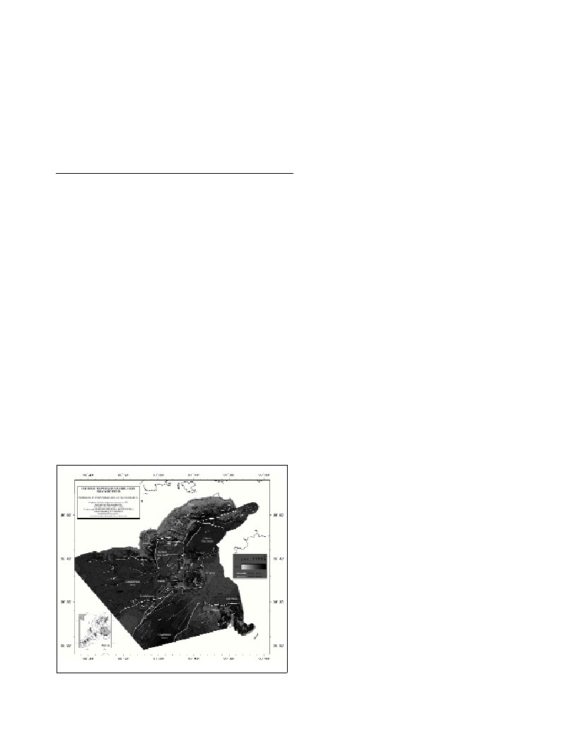
created (Fig.1).
Morphotectonic structure of Kos-Nisyros Volcanic Field
A neotectonic graben structure which is developed in an E-W
general direction, between the alpine basement of Kos Island to the
north and the alpine basement of Tilos Island to the south, is formed
by a subsidence of the alpine basement rocks, of the order of 2,5 Km
due to the marginal fault zones of Southern Kos and Northern Tilos.
Within the tectonic graben of Nisyros and surrounding islets, there is
a number of faults (1), which are limited mainly in the central part of
the area creating a minor internal tectonic horst structure which is
better expressed in the area of Kondeliousa islet, producing a median
platform, with NE-SW and ENE-WSW general trend. The western
part of this horst is composed of Mesozoic limestones in Kondeliousa
islet while the eastern part, both offshore and onshore, is constructed
by Quaternary volcanic formations. In the area of Nisyros and Yali
islands minor faults overprint the previous ENE-WSW horst structure.
Five distinctive basins can be distinguished on both sides of the
median platform of Kondeliousa and its eastern prolongation to the
volcanic islands of Nisyros, Yali, Pachia, Pergousa and Strongyli.
North of Kondeliousa-Nisyros platform occur: a) The Kondeliousa
basin, expanding up to the western Kos platform with depths of about
550m, b) the Western Kos basin, with an average depth of 520m,
among Kefalos peninsula and the islets of Yali and Pachia and c) the
Eastern Kos basin, with an average sea-bottom depth of 630m
separated from Western Kos basin by a relatively shallow rise between
Yali and Kos with a depth of approximately 400m. South of
Kondeliousa-Nisyros ridge occur: d) the northern end of the large
Karpathos basin, reaching more than 2000m towards the south and e)
eastwards the Tilos basin between Tilos and Nisyros with depths more
than 600m.
A number of volcanic centres has been described around Nisyros
Island (2, 3), developed within the neotectonic graben, in shallow
areas. These are (Fig 1a): 1) The Nisyros caldera with a top of the rim
at +580m and a bottom at +80m 2) The Yali Volcano which exhibits a
partly submerged caldera (bottom ñ300m, top +170m), 3) The
Strongyli Volcanic Cone, which starts from ñ650m depth of the sea-
bottom up to +120m 4) The submarine caldera northeast of Strongyli
in the depth of -670m up to ñ590m, 5) The Pergousa Volcanic Cone
(bottom ñ400m, top +100m), 6) The domes of Prophitis Ilias (bottom
ñ270m, top +698m), 7) The volcanic domes of Pachia Islet (bottom
ñ250m, top +150m), and 8) the submarine volcanic domes to the east
of Kondeliousa Islet (bottom ñ400m, top -80m). The lack of
sediments overlying the volcanic domes indicates their very young
age, ranging between Upper Pleistocene and Holocene.
References
1-Nomikou, P., Papanikolaou, D., 2000. Active geodynamics at Nisyros,
the eastern edge of the aegean volcanic arc: emphasis on the submarine
survey. Proceedings of the 3rd Int. Conf. Geology East. Mediterranean,
Sept. 1998, pp. 97-103.
2-Papanikolaou D., Nomikou P., 2001. Tectonic structure and volcanic
centres at the eastern edge of the Aegean Volcanic Arc around Nisyros
island. Bulletin of the Geological Society of Greece, Vol. XXXIV/1, pp.
289-296, Proceedings of the 9th International Congress, Athens,
September 2001.
3-Nomikou, P., Papanikolaou, D., Alexandri, M., 2003. Variating modes
of submarine volcanism within the Kos-Nisyros volcanic field. Abstracts
IUGG, July 2003, Sapporo, Japan.