MONITORING BARCELONA CITY BEACHES USING VIDEO (ARGUS) AND LASER (LIDAR) METHODS
Elena Ojeda
1*
, Jorge Guillén
1
and Antoni Ruiz
2
1
Dept. de Geología Marina y Oceanografía Física - Instituto de Ciencias del Mar (CMIMA-CSIC), Barcelona, Spain
* eojeda@icm.csic.es
2
Institut Cartografic de Catalunya, Barcelona, Spain
Abstract
This contribution presents video camera and laser techniques describing the coastline evolution in Barcelona city beaches over a 4-month
period during 2002. LIght Detection And Ranging (LIDAR) measurements were obtained by the Institut Cartografic de Catalunya in April,
17 and July, 23, whilst Argus measurements were obtained from Mapfre station by the Instituto de Ciencias del Mar hourly from April to
July. Both techniques’ability to locate the coastline is compared, obtaining similar results. Argus high temporal resolution sampling in
conjunction with LIDAR three-dimensional view of the emerged beaches, more spaced in time, appears to be a valuable procedure for
monitoring the beaches.
Keywords: Argus, LIDAR, coastline evolution, Barcelona
Rapp. Comm. int. Mer Médit., 37,2004
61
Introduction
The objective of this study is to examine the evolution of three
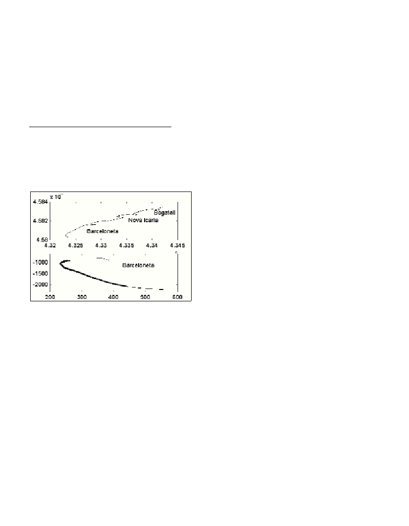
beaches of Barcelona (Barceloneta, Nova Icaria and Bogatell) using
the technology provided by Argus and LIDAR (Fig. 1).
Coastal cartography is one of the main applications of LIDAR. It
has many advantages over aerial photogrammetry in coastal areas,
accuracies around 10 cm in height and sampling densities around 1
point/m
2
are easy to achieve with the system.
Fig. 1. Top: studied beaches in Barcelona (UTM). Bottom. LIDAR and
Argus coastlines represented in local coordinates (meter). LIDAR in light
black line, Argus in bolded line.
Two ?ights were done in 2002, at an altitude of 2,300 m over the
coast of Barcelona to demonstrate the possibilities of this technique:
on April 17 and July 23. In both cases the point density was 0.5
point/m
2
and a digital terrain model (DTM) of 1-m grid step was
computed (1).
The ARGUS system (2) is an automated video station, comprising
five video cameras connected to an image processor, which controls
the communication to the outside world. The station placed on 21
st
October 2001, monitors Barcelona city beaches (3). It is located atop
Mapfre building (approximately 146-m high) covering a 2-km radio
and spanning a 180ş view. Sampling every daylight hour in a ten
minutes register (http://argus.cmima.csic.es).
Since Argus installation in October 2001, a highly energetic period
occurred in the region with important storms (November, December
2001; January, March 2002) producing extensive sediment transport
and severe erosion problems. Approximately a week prior to the first
?ight with LIDAR, a storm with E direction and significant wave
height (Hs) of 2.6 m (4)took place in the region (April, 11-12).
Moreover the beaches situation changed over the study period, due to
a second storm coming from the East (May 7-8), with maximum Hs
reaching 3.8 m (4). Finally, a beach nourishment (150 000 m
3
) was
carried out in Barceloneta and Bogatell beaches (June 13 to July 17).
Coastline evolution
The impact of single storm events is derived from Argus images.
Extraction of coastlines and images examination reveals that, as
pointed above, the coastline previous to the May storm find an eroded
beach due to the unusually energetic wave pattern. This can explain
the fact that the beach erosion was of the same magnitude than during
the less energetic storm taken place in April.
The storm occurred in May produced three different erosion patterns
on each of the beaches. Bogatell´s coastline suffered erosion/accretion,
eroding 10 m in the northern side and accreting around 5 m in southern
part. Nova Icaria did not show significant differences, whilst
Barceloneta suffered a landward migration of about 5 m.
Nourishment took place from June 13 to July 5 in Bogatell and July
5 to 17 in Barceloneta. Using Argus images the nourishment effecti-
veness have been studied by means of temporal variations of the
coastline in given locations of Bogatell and Barceloneta. It has been
seen that the replenishment of the beaches evolves, with erosion
happening until some stabilization is reached.
LIDAR versusArgus coastlines
An important point in this study is the comparison of the results
obtained using both methodologies. Two different coastlines were
derived from LIDAR. The first one using the texture of the DTM to
discriminate the sand from the sea. A shadow map was computed
from the DTM with a very low illumination source and the coastline
was drawn from this image. The second coastline was derived from
the intensity map of the pulse return. The most similar results were
obtained using the second method (Fig. 1).
With LIDAR the volumes of sand displaced can be accurately
measured from the differences of DTMs. As the sensor cannot take
bathymetric measurements, the sand added or removed under water is
not taken into account in the calculations. Using this method and the
LIDAR-derived coastlines it has been estimated in Bogatell an
increase in volume of around 24000 m
3
corresponding to an increase
in surface of 12000 m
2
. This corresponds to 2 m
3
/m of sand necessary
to get a coastline accretion of 1m.
Conclusions
The study of Barcelona beaches using video images reveals that,
despite the fact that they are closed beaches due to man-made
structures, they have differential morphological evolution. Argus
provides high-resolution information about shoreline changes after
storms and beach nourishment.
Argus and LIDAR methods offer similar results for measuring the
coastline position. LIDAR capability to measure 3D characteristics
supplies accurate measurement of volume changes in the emerged
beach.
Argus and LIDAR are complementary methods in morphodynamic
studies. It is suggested to combine both techniques in order to obtain
precise information of the beach evolution, persist in Argus continuous
sampling, adding 3D information from specific LIDAR surveys.
References
1-Ruiz A., Kornus W. 2003 Experiencias y aplicaciones del LIDAR. V
Semana Geomática, 11.2.03 - 14.2.03, Barcelona.
2-Holman, R.A., Sallenger, A.H., Lippmann, T.C., Haines, J., 1993. The
application of video image processing to the study of nearshore processes.
Oceanography, 6(3): 78-85.
3-Guillén, J., Chic, O., Ojeda, E., Palanques, A., Aarnikhoff, S., 2003.
Monitorización de las playas de la ciudad de Barcelona utilizando
imágenes de video: evolución de la línea de costa en respuesta a
temporales y regeneración artificial (2001-2002). VII Jornadas Espańolas
de Ingeniería de Costas y Puertos, Libro de Resúmenes, M. Losada,
M.Castillo (eds.) pp. 254-256.
4-Banco de Datos Oceanográficos de la Dirección General de Puertos y
Costas. Modelo WANA de generación de oleaje. Punto 2066051.