RECENT FAULT ACTIVITY AND THE INTERACTION WITH CARBONATE DEPOSITIONAL SYSTEMS
IN THE ALBORÁN SEA (WESTERN MEDITERRANEAN SEA) BY SUBBOTTOM PROFILERS
K. Reicherter
1*
, Ch. Betzler
2
, Ch. Hübscher
3
1
Institut für Geophysik und Geologie, Universität Leipzig, Leipzig, Germany - * reicherter@dkrz.de
2
Geologisches-Paläontologisches Institut, Universität Hamburg, Hamburg, Germany
3
Institut für Geophysik, Universität Hamburg, Hamburg, Germany
Abstract
An ultra-high resolution seismic study in the Alborán Sea was carried out with the Parasound system to study the recent tectonic activity
of prominent fault systems and their interaction with Quaternary carbonate systems. Since the Late Miocene, the Alborán Sea and
surrounding areas are subject to compression, which in?uences the depositional history including coastal Quaternary carbonates. The
western Mediterranean is characterized by a moderate seismicity, generally tracing major sinistral strike-slip faults, which cut the entire
basin. These faults, the Carboneras and Palomares Faults, truncate and warp the Quaternary sediments pointing to recent fault activity in
the Gulf of Almería.
Keywords: active tectonics, Alborán Sea, earthquakes
Rapp. Comm. int. Mer Médit., 37,2004
65
The Alborán Basin located within the Eurasian-African Conver-
gence Zone that is an approx. 500 km wide corridor with distributed
seismicity (Fig.1) which exhibits several structures related to neotec-
tonic deformation. Regions of adjacent coeval compression and exten-
sion in an overall dextral transpressional setting are found in the
Alborán Basin which is dominated by strike-slip faulting.
Fig. 1. Tectonic map of the Alborán Sea, with the recent seismicity (dots,
filled dots =deep earthquakes). Inset shows study area and section of
Fig.2. CF = Carboneras Fault, PF = Palomares Fault.
In order to image late Quaternary depositional and tectonic
processes in the Alborán Sea the German research vessel R/V Meteor
operated along the Almería coast in the year 2001 (M51/1 cruise). The
area has been previously investigated by a number of high- and low
resoluton seismic studies (1; 2 Fig.3A), which outlined the complex
Neogene tectonics in the western Mediterranean region. Two active
left-lateral strike-slip faults, the NE-SW striking Carboneras Fault and
the N-S trending Palomares Fault, control the depositional conditions
of the carbonate prism of Cabo de Gata region (Fig.2).
Fig.2. Parasound section (topography and sediments) across the Gulf of
Almeria and the Cabo de Gata (see. Fig.1)
Historical data point to major earthquakes during the last 1000
years (3), which occurred along the major strike-slip faults. The last
earthquake with a magnitude > 6.2 occurred on 15. September 1522,
destroying Almería. On-shore paleoseismic evidence with surface
ruptures is missing (4), the epicenter is unknown. In Parasound
investigations, we have found several fault strands in the Gulf of
Almería (deep channels in Fig. 2), some of which are associated with
faults, folds and onlap-patterns (Fig.3B). The faulted recent
sediments in an area of relatively high sedimentation rates, lead us to
the conclusion that off-shore faulting must be very recent. An off-
shore epicenter related with the earthquake of 1522 is also
corroborated by historical tsunami drawings. Hence, we contribute to
a seismic hazard assessment of the Western Mediterranean region.
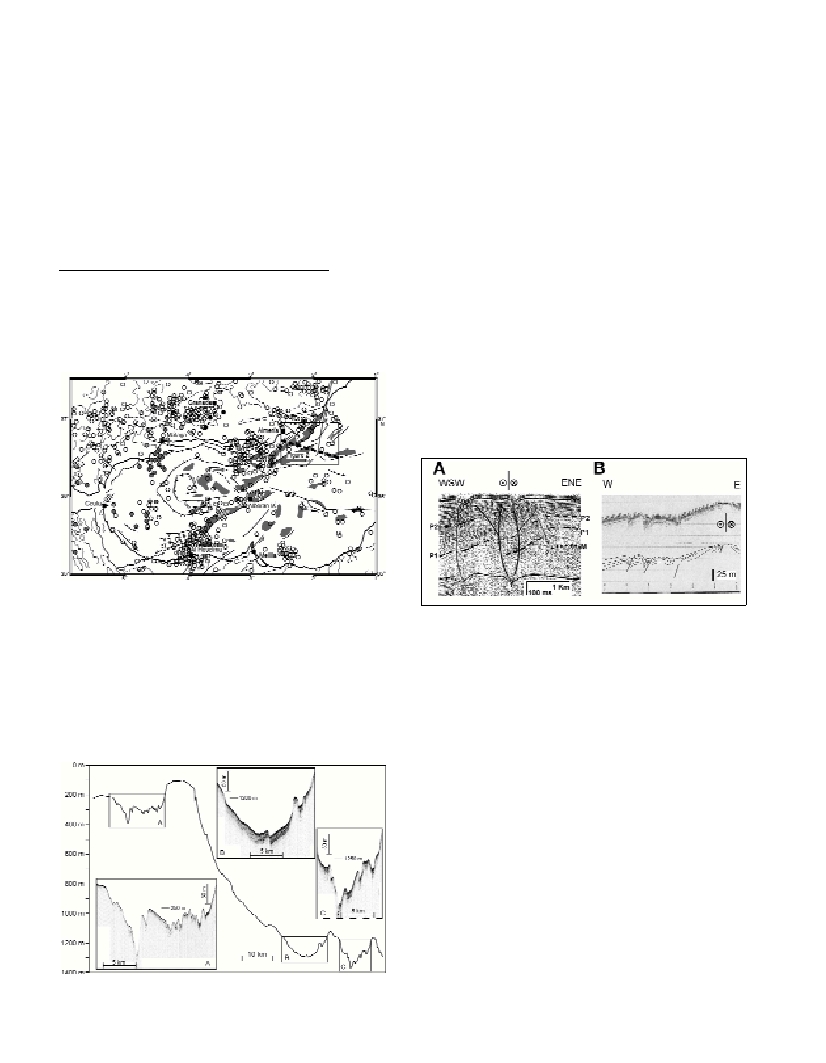
Fig. 3. A seismic section from Estrada et al.,1997; B Parasound section
(location on Fig.2 platform left of A). Note folding and faulting of the
recent sediments.
References
1-Ercilla, G., Alonso, B., Baraza, J., 1994. Post-Calabrian sequence
stratigraphy of the northwestern Alboran Sea (southwestern
Mediterranean). Marine Geology, 120: 249-265.
2-Estrada, F., Ercilla, G., Alonso, B., 1997. Pliocene-Quaternary
tectonic-sedimentary evolution of the NE Alboran Sea (SW Mediterranean
Sea). Tectonophysics, 282: 423-442.
3-Reicherter, K., 2001. Paleoseismological advances in the Granada
Basin (Betic Cordilleras, southern Spain). Acta Geol. Hisp., 36: 267-281.
4-Reicherter, K., Reiss, S., 2001. The Carboneras Fault Zone
(southeastern Spain) revisited with Ground Penetrating Radar -
Quaternary structural styles from high-resolution images. Netherlands
Journal of Earth Science, 80: 129-138.