IDE-COSTES: A LOCAL INFORMATION SYSTEM FOR MANAGING THE COAST IN CATALUNYA (SPAIN)
Serra J.
1*
, Guimet J.
2
, Montori C.
1
, Roca E.
1
and Gelizo O.
1
1
Institute of Environmental Science and Technology (ICTA), Autonomous, University of Barcelona, Spain - gr.eurosion@uab.es
2
IDEC (SDI of Catalonia, Barcelona, Spain - JGuimet@icc.es
Abstract
The lack of information and coordination among administration, research centres and socio-economical sectors is one of the main
problems in coastal erosion management at local level. One of the aims of the EUROSION project (www
.eurosion.or
g
), is to improve or
implement a local information systems that should provide quality and complete information of the coastal area, and facilitate the decision
making process in coastal erosion. (1) Four pilot sites are selected for the design, realisation and set-up a local information system (2).
This paper aims at describing the local information system set-up for the Catalan site of Sitges in Spain, with its goals and functionalities.
Keyworkds: Coast, metadata, map server, Catalonia
Rapp. Comm. int. Mer Médit., 37,2004
67
Introduction
One quarter of the European Union’s coast is currently eroding
despite availability of a wide range of measures to protect shorelines
from eroding and ?ooding. Therefore the DG Environment commis-
sioned a consortium led the Dutch National Institute for Coastal and
Marine Management (RIKZ) to carry the EUROSION project. One of
the aims is to produce results of immediate value for policy-makers,
managers and researcher to deal with coastal erosion in the most
sustainable way. One example of such a product is a local information
system that will provide “a set of technological, human, organisatio-
nal, financial, and information resources organised in such a way to
improve archiving, retrieval, representation, exchange and dissemina-
tion of information produced by institutions involved in shoreline ma-
nagement and on a specific area”(3).
During the project several pilot sites were selected where an in-
depth study and analysis was executed towards several assessment
levels (4). The lack of access to useful information and coordination
among administration was highlighted and the proposal of a local
information system was pointed out as a valuable tool to provide
quality and complete information of the coastal area, and facilitate the
work for policy makers and managers.
This paper introduces the case study of Sitges in Spain, where a LIS
was designed in the frame of a Catalan initiative called IDEC (SDI of
Catalonia). It is a consolidated initiative of the autonomous govern-
ment of Catalonia, financed by the Secretary of Information Society
and managed by Catalan Institute of Cartography, which aims at
creating an Infrastructure of Spatial Data for Catalonia, through a
catalogue of Metadata of georreferenced information under Standard
ISO 19.115. Local information system for the coast will be hold under
the umbrella of IDEC as a sector IDE called IDE-COSTES. Next the
main components of IDE-COSTES are going to be described.
Ide-costes description
The main services that IDE-COSTES offers are contained in a web
site (www
.geoportal-idec.net/idecostes/
) with a friendly user
interface, free accessible. A part from the usual services such as News,
Links, Documents, Information and Forum, main specific services are
directly accessible except for the upload module, which is a stand-
alone software component downloadable from it.
IDE-COSTES is oriented to a broad group of user so it has a
multilingual interface in Catalan, Spanish and English languages.
Metadata capture, editing and export-import function
The information providers and all those who have information
about the coast will have to be able to describe it properly so its is
possible for interested third parties to locate it, discover it and find out
about its characteristics. This involves the generation of metadata. To
fulfil this aim a stand-alone software component, called MetaD, has
been created in the frame of the whole IDEC initiative. It is made
using Visual Basic and an Access database, which can be installed in
a PC or network using Windows 98, 2000, XP or NT. The capture
formulas are based on the standard ISO 19115.
After user generates metadata, it is exported in XML format and
stored in an Oracle BdData, which is also connected to ArcSDE and
ArcIMS software to support the spatial searches.
Metadata search (internet catalogue server)
The software component called Catalogue Server, which complies
with OGC interoperative specifications (WCS 1.0 OGC), enables
access and consultation to the catalogue of metadata. It forms part of
the services accessible via the IDE-COSTES geoportal.
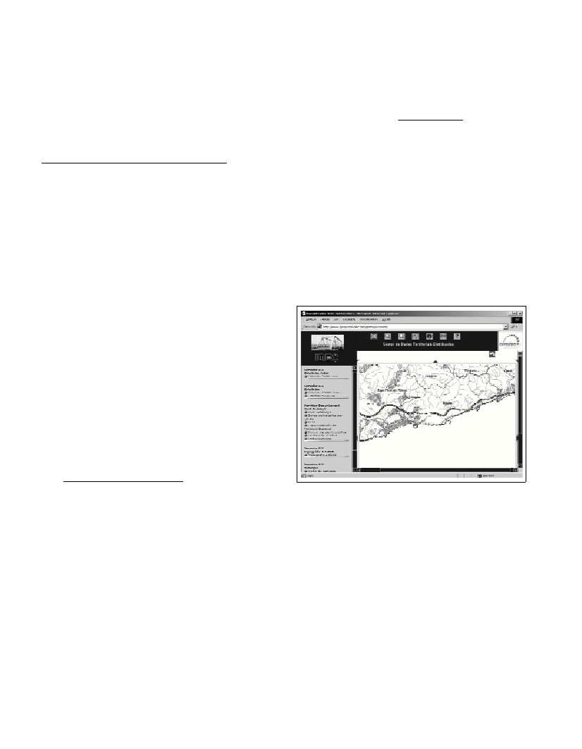
Access to geographical data (map server)
This function enables access to and display and consultation of
(simple or combined) cartographic data. This is based on a specialised
component of the system, a WMS Client that complies with OGC
specifications.
Conclusion
The idea of establishing IDE-COSTES is to improve and increase
access to the information by the whole community so its participation
in the decision making process can be more active and better-
informed, providing it with the suitable tool for this purpose.
Several drawbacks have to be mentioned however, such as the
maintenance and continuous manual generation of metadata records
and costs for maintenance of the system.
Fig 1. Screenshot of the map server of IDE-COSTES.
References
1-Lombardo, S., Niesing, H., Salman, A., Lucius, I., 2002. Capitalising
knowledge for managing coastal erosion: the EUROSION initiative. Pro-
ceedings of the 6th Conference Littoral 2002: The Changing Coast, vol. I,
eds. Eurocoast, pp. 77-84, 2002.
2-H. Niesing, Serra J., Montori C., Villares M., Roca R., Gelizo O., 2003.
Local Information System as a Tool for the Coastal Erosion Management.
Proceedings of the Sixth International Conference on the Mediterranean
Coastal Environment, MEDCOAST 03. E.Özhan (Editor), Ravenna-Italy,
7-11 October, vol.I, pp. 179-183.
3-EUCC-The Coastal Union, 2002. Coastal Erosion Policies: Defining
the Issues. Scoping study. EUROSION project. Leiden-The Netherlands.
4-Serra J., Montori C., Villares M., Roca R., Gelizo O., 2002. Eurosion:
Assessment on local information system for coastal erosion management.
Littoral 2002. The changing Coast,EUROCOAST/EUCC, Porto-Portugal,
22-26 September, vol.3, pp. 271-275.