APPLIED NEOTECTONIC MAPPING TO THE CIVIL ENGINEERING: FAULT ACTIVITY MAP
OF THE BOLONIA AREA (THE GIBRALTAR STRAIT TUNNEL, SOUTH SPAIN)
P.G. Silva
1*
, J.L. Goy
2
, C. Zazo
3
, T. Bardaji
4
, J. Lario
5
, L. Somoza
6
, L. Luque
2
and F.M. González-Hernández
2
1
Depto. Geología, Universidad de Salamanca, Escuela Politécnica Superior de Ávila, Avila, Spain - * pgsilva@gugu.usal.es
2
Depto. Geología, Universidad de Salamanca, Fac. Ciencias, Salamanca, Spain
3
Depto. Geología, Museo Nacional de Ciencias Naturales (CSIC), Madrid, Spain
4
Depto. Geología, Universidad de. Alcalá de Henares, Madrid, Spain
5
Depto. Ingeniería Geológica y Minera, Univ. Castilla – La Mancha, Fac. Ciencias del Medio Ambiente, Toledo, Spain
6
División de. Geología Marina, IGME, Madrid, Spain
Abstract
A map of Fault Activity has been developed for preliminary engineering planning related to the construction of an underwater fixed link-
route between Africa and Europe at the Gibraltar Strait Sector, in South Spain (The Gibraltar Tunnel). The criteria management is mainly
focused on the establishment of the seismic or aseismic character of individual fault traces. From this study, the Cabo de Gracia strike-slip
fault (NE-SW) can be catalogued as active during at least the last 128 ka BP, and as a probable seismic source of moderate events
(Mb
=
5), with relevant incidence in the ancient Roman city of Baelo Claudia(AD 40-60 and AD 350-395).
Keywords: Neotectonic mapping, fault activity, ground Instability, Gibraltar Strait, Spain
Rapp. Comm. int. Mer Médit., 37,2004
68
Preliminary planning for the establishment of a permanent link-
route between Europe and Africa (Gibraltar Strait Tunnel), promoted
by the EU and supported by the National Companies SECEG S.A.
(Spanish) and SNED (Moroccan), was completed in 1995. Among the
set of research projects carried out during this phase, a neotectonic
analysis of the Gibraltar Strait was developed devoted to the imple-
mentation of an onshore 1:100.000 Neotectonic Map of the Spanish
coast (1). Research was mainly focused on the identification of regio-
nal neotectonic hazards related to the construction and future use of a
high-sensitive installation like an underwater tunnel of more than
20km long and therefore to identify those areas subject to potential
(pure and induced) seismotectonic hazards. For this last topic detailed
fault mapping (sc. 1:25.000) of selected pilot zones was also
performed.
One of the selected areas was the Bolonia Bay (Cádiz). Late
Quaternary faulting, large landslides, and swelling clayey units occur
at this small sector of the Gibraltar Strait coast, constituting an
excellent zone to test the performance of detailed mapping of
neotectonic hazards. Mapping has been focused on the identification,
and preliminary characterisation, of potentially active faults and un-
stable terrains for later engineering planning. Map presented here is
mainly based on the neotectonic mapping guidelines established for
the Spain (2 and 3) and France (4) and consequently it came from the
integration of neotectonic, seismic, and paleoseismic data, on a gra-
phic background generated by the Quaternary geology and geomor-
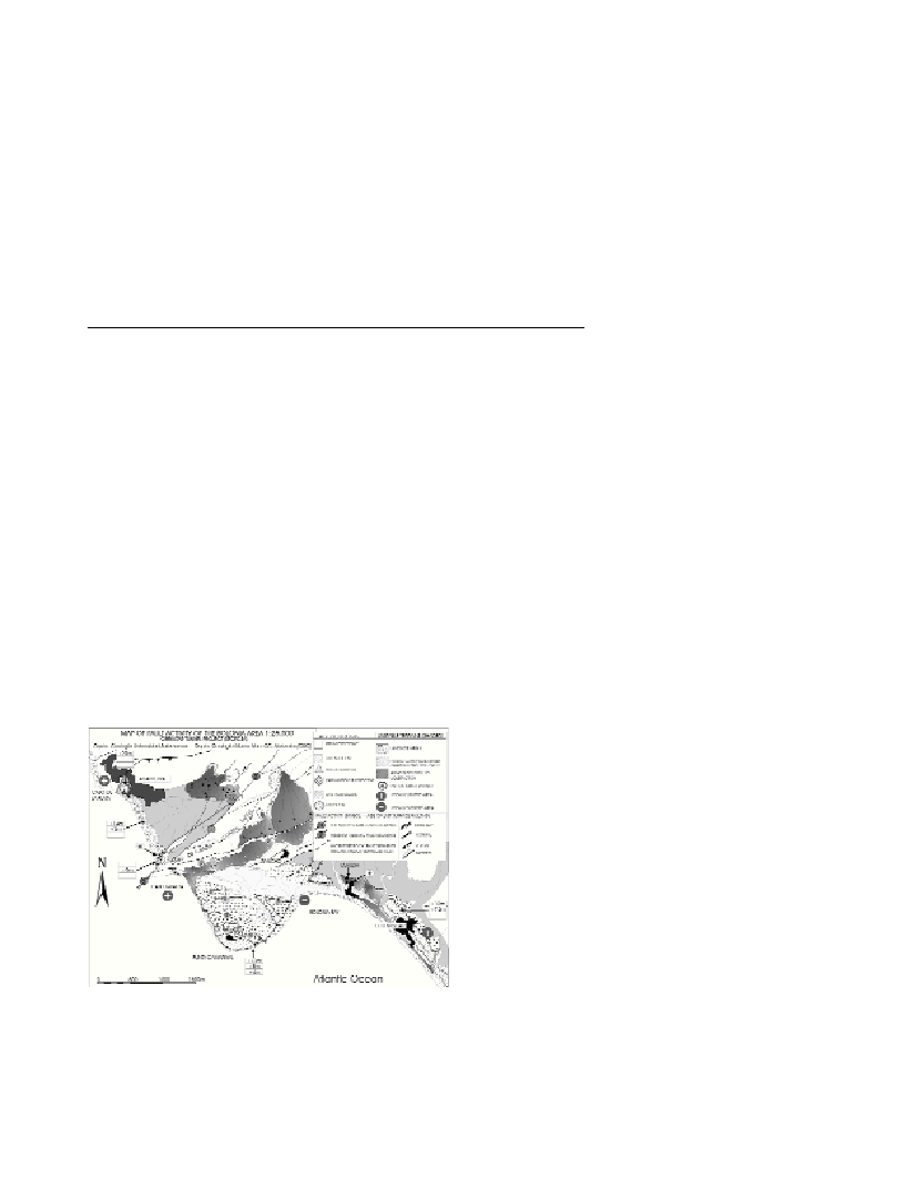
phology (Fig. 1).
Fig. 1. Pilot Fault Activity Map of the Bolonia area.
The final purpose is the development of comprehensive
methodology for the graphic representation (chart-format) of geo-
hazards related to ground conditions, seismicity and fault activity. For
this the age of the last deformational event, and slip rates (where
possible) are taken into account, but their classification as active or
inactive structures is avoided. In the map, the different fault segments
have been differentiated according to the age of the last known defor-
mational event: Late Pleistocene-Holocene (circles); Middle-Early
Pleistocene (pentagons); Plio-Pleistocene (triangles); Pliocene, and
Pre-Pliocene (no symbol). In addition, fault segments of different ages
have been subdivided into two categories,
a
and
ß
faults following the
proposals of (4) and (5).
a
fault segmentsare seismic (or seismogenic)
segments, in other words, fault segments which can be linked to
present seismic activity and display deformations in Late Quaternary
deposits and/or landforms.
ß
fault segmentsare presently aseismic
segments, but displaying evidences of paleoseismic deformations (of
Quaternary age) and therefore potentially seismic segments.
Aside from these linear seismotectonic hazardous features, the
uplift/subsidence trends of the different coastal sectors have been also
highlighted by means of specific symbols, in order to illustrate the
more recent vertical behavior of the different coastal sectors (Fig. 1).
Finally, as evidenced by the geomorphic analysis, landscape dynamics
holds a major sensitivity to more localized phenomena of both, mass-
movements favored by the occurrence of low-cohesive bedrock clayey
units (Almarchal and Facinas fms), and near-surface liquefaction on
unconsolidated littoral sandy deposits and deep weathered Pliocene
conglomerates. Since the recognition of unstable grounds is critical
for large-scale engineering planning, units prone to suffer surface-
destabilization by an expected moderate earthquake have been also
highlighted in the map through specific patterns. As indicated by
several authors (6 and 7) 0.16g are large enough to promote slope
failure close to the coast, but also near-surface destabilization on
unstable ground, as evidenced by the geologic, geomorphologic and
archeological records (7).
Acknowledgements: Projects CSIC, USAL, Secegsa and Fund.
Areces.
References
(1)-Goy, J.L., Zazo, C., Silva, P.G., Lario, J., Bardají, T., Somoza, L.,
1995. Evaluación geomorfológica del comportamiento neotectónico del
Estrecho de Gibraltar (Zona Norte) durante el Cuaternario. In: M. Esteras,
(ed..), El Enlace Fijo del Estrecho de Gibraltar, SECEGSA, Madrid, Vol.
2, pp. 51-69.
(2)-Goy et al., 1991 Goy, J.L., Silva, P.G., Zazo, C., Bardají, T., Somoza,
L., 1991. Model of Morpho-Neotectonic map and legend. Bull. INQUA
N.C.,14: 19-31.
(3)-Baena, J., Barranco, L.M., Zazo, C., Goy, J.L., Estevez, A., Sanz de
Galdeano, A. Bardají, T., Silva, P.G. Somoza, L., Rodríguez-Estrella, T.,
1994. Mapas Neotectónico, Sismotectónico y de Actividad de Fallas de la
Región de Murcia, Madrid, Spain. ITGE-CARM, 101 p.
(4)-“REGINE Group”: Beles, J.L., Colleau, A., Fourniget, J., Godefroy,
P., Lęnotre, N., Sauret, B., Combes, P., Dubie, J., Vaskou, P., 1991.
Proposal for classification of fault activity in an intraplate collision setting
definitions and examples. Tectonophysics, 194: 279-293.
(5)-Mariolakos, I., Silva, PG., Fountdoulis, I., Nassopoulos, S., Kranis,
H., 1998. Evaluation of Questionnaire for Large-scale neotectonic
mapping. Abst. 1
st
Int. Workshop on Formalization of Neotectonic Maps,
Patra, Greece.
(6)-Baraza, J., Ercilla, G., Lee, J., 1992. Geotechnical properties and
preliminary assesment of sediment stability on the continental slope of the
Nortwestern Alboran Sea. Geo-Marine Letters, 12: 150-156.
(7)-Silva, P.G., Borja, F., Zazo, C., Goy, J.L., Luque, L., Lario, J., Dabrio,
C.J. and Bardají, T. (in press). Paleoseismic record at the ancient Roman
City of Baelo Claudia (Cádiz, South Spain). Tectonophysics.