THE NEOTECTONICS OF THE GULF OF GÖKOVA:
SOUTHEAST AEGEAN SEA-SOUTHWESTERN TURKEY
Atilla Ulug
1*
, Muhammet Duman
1
, Sükrü Ersoy
2
, Erdeniz Özel
1
, Mert Avci
1
1
Dokuz Eylul University Institute of Marine Science and Technology Baku Bulvari, No: 10, 35340 Inciralti, Izmir, Turkey
ulug@imst.deu.edu.tr
2
Yildiz Technical University, Natural Science Research Center, Besiktas, Istanbul, Turkey - sersoy@ytu.edu.tr
Abstract
The Sedimentary and tectonic Late Quaternary evolution of the Gulf of Gökova, located at the southwest Anatolia–southeastern Aegean
Sea region, has been interpreted from 3.5 kHz and single channel airgun seismic re?ection profiles. The oldest part of the Gökova basin
is bounded by mainly E-W trending faults, and filled by Miocene–Pliocene–Quaternary hemipelagic sediments with thickness up to 2.5
km. Younger active faulting, the so-called Gökova Transfer Fault, trends NE in the central part of the Gulf of Gökova basin and records
sinistral strike-slip motion broadly parallel to the convergence motion of the Aegean-Anatolian and African plates.
Keywords: Aegean Sea, Seismic stratigraphy, Neotectonics
Rapp. Comm. int. Mer Médit., 37,2004
70
Introduction
In the Mediterranean the Aegean Sea is a region of active
extensional tectonism within the overriding part of a convergent plate
margin system (Africa with respect to Europe). The tectonic
framework of western Turkey comprises numerous east-west trending
graben, associated with the regional north-south extension of the
Aegean plate (1). Detailed studies (2) in Aegean Sea show that there
have been significant changes in the fault patterns during the
Quaternary. The Gulf of Gökova is located in the southeast Aegean
Sea, along the coast of southwest Anatolia, which is a region
including most of the major rifts and grabens. The Gulf has about 90
km E–W length and 25 km N–S width and it is bordered by Datça
Peninsula to the south, the island of Kos to the west and Bodrum
Peninsula to the north. The Gökova region is a part of the western
Anatolia–Aegean Sea area, which is presently submitted to an N–S
regional extensional tectonic system. The imprints of this extensional
regime are clearly seen in the geology and geomorphology of western
Anatolia, as well as in the bathymetry of the Aegean Sea.
The Gökova province is mainly characterized by two successive
tectonic regimes. These overlapping rift and graben systems are well
seen in the land geology. The first one is the N–S compressional
paleo-tectonic regime, possessing the later counter-clockwise
rotation, and resulted in a NW–SE rift and graben system. The
NW–SE-oriented paleotectonic rifts and grabens, i.e., Milas–Ören
and Yatagan MuglaRifts, are filled by mainly Middle Miocene to
Quaternary deposits of continental origin. The second one is the
neotectonic regime, possessing the N–S extension that has resulted in
mainly E–W-oriented rift and graben systems, i.e., Gökova Rift (3).
The Gulf of Gökova was mainly opened by an E–W-oriented, major
normal listric Datça Fault (Fig 1). The estimated overall rate of
extension in the gulf is at least 1.1 mm/y and the amount of total
extension is at least 5.5 km (4).
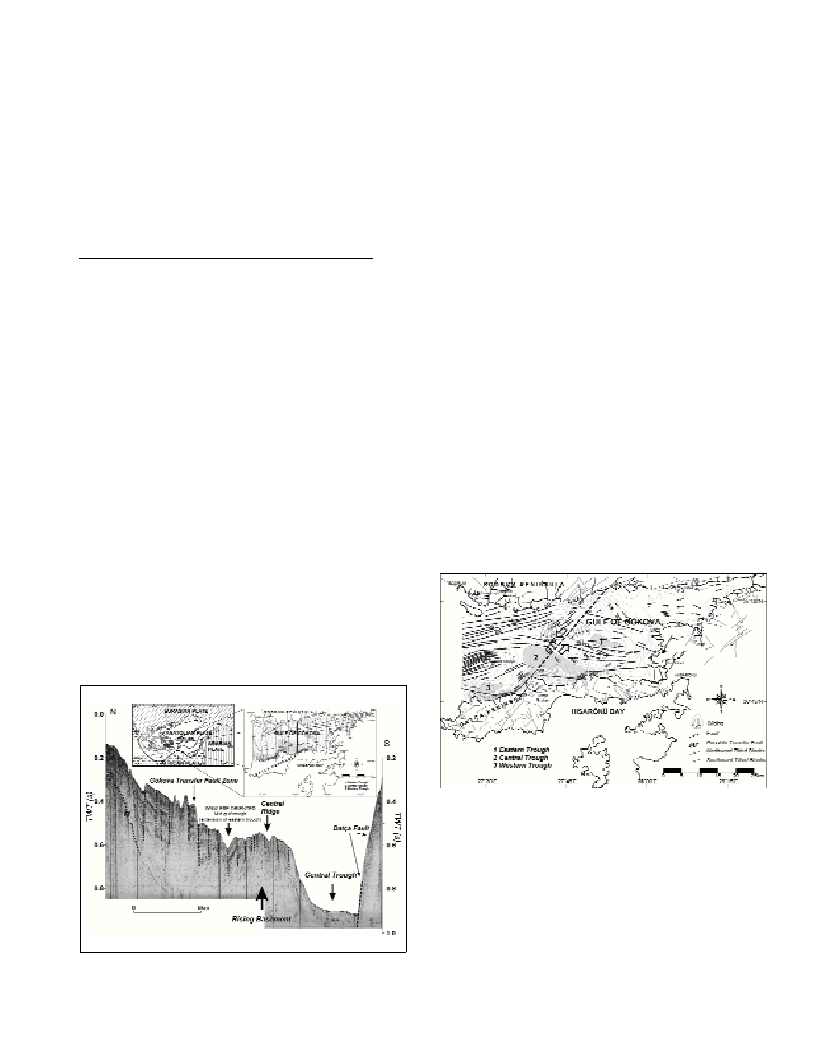
Fig. 1. Airgun profile from the Gulf of Gökova. Inset shows the survey
lines and the location of pofile as heavy line. Sub-vertical dashed
lines=faults, M=Multiple. Profile is ca. 20 km long.
Results
At least five superimposed deltaic sequences, separated by major
erosional unconformities, occupy the shelf and the basin slope region
of the northeastern Gulf of Gökova. The oldest recognized delta
sequence (DS5) probably dates from isotopic stages 10 (ca. 0.34 Ma).
Marine isotopic stage 10 unconformity separates DS4 and DS5; and
lies approximately 215 m below the present sea-level. The tentative
age assigned to the delta sequences yields rates of tectonic subsidence
to be appraised. In the northeastern slope of the basin the late
Quaternary tectonic subsidence is about 0.3-0.4 m/1000yr and is
probably related to basement graben structures.
Gulf of Gökova is mainly opened by the E–W-oriented, buried
Datça Fault located at the south and its antithetic faults located at the
north (Fig. 1). The Datça Fault might have begun to work in the Latest
Miocene–Pliocene. In terms of local rather than regional effects, its
activity has been decelerated, possibly since the Pleistocene. The
continuing extension in the area may have initiated a second phase of
faulting, e.g., WNW–ESE-oriented subgrabens in the central gulf and
major WSW–ENE normal faulting at the northwest margin. Younger
active faulting so-called Gökova Transfer Fault (GTF) (Fig. 2) trends
NE in the central part of the Gulf of Gökova basin and records
sinistral strike-slip motion broadly parallel to the convergence
direction of the Aegean-Anatolian and African plates.
Fig. 2. Tectonic map of the study area, showing major faults with ticks at
downthrows. The faults on land were adopted from (3). GTF Gökova
transfer fault.
References
1-Dewey, F.J., and Sengör, A.M.C., 1979. Aegean and surrounding
regions: complex multiplate and continuum tectonics in a convergent
zone. Geol. Soc. Am. Bull.,90: 84-92.
2-Piper, D.J.W. and Perissoratis, C., 2003. Quaternary neotectonics of the
South Aegean arc. Marine Geology.,198: 259-288.
3-Görür, N., et. al., 1995. Rift formation in the Gökova region, southwest
Anatolia: implications for the opening of the Aegean Sea. Geol. Mag.,
132: 637–650.
4-Kurt, H., Demirbag, E., Kusçu, I.,1999. Investigation of the submarine
active tectonism in the Gulf of Gökova, southwest Anatolia–southeast
Aegean Sea, by multi-channel seismic re?ection data. Tectonophysics,
305: 477–496.