MESOSCALE ACTIVITY IN THE SOUTHERN ADRIATIC AS EVIDENCED FROM A DEEP-SEA MOORING
Vanessa Cardin
1
, Miroslav Gacic
1
* and Birgit Klein
2
1
OGS, Borgo Grotta Gigante, 34010 Sgonico (Trieste), Italy - vcardin@ogs.trieste.it
2
University of Bremen, Institute of Environmental Physics, Bremen, Germany
Abstract
Deep-sea mooring recording temperature and salinity together with the upward looking Acoustic Doppler Current Profiler (ADCP) located
at 300 m depth, was maintained from mid-October 2002 until 8 May 2003. The mooring was situated at a position where presumably an
open-ocean convection in the Southern Adriatic takes place. In the pre-conditioning period rather smooth variations of the temperature and
salinity were noticed. During the convection period high-frequency variations on the scale of about ten days, were very prominent. These
were explained in terms of passage of mesoscale eddies formed along the border of the deep convection patch.
Keywords: Adriatic Sea, Acoustic Doppler Current Profiler record, mesoscale eddies
Rapp. Comm. int. Mer M�dit., 37,2004
89
Introduction
The open-ocean vertical convection has been considered as the
most important mechanism in forming the Adriatic Dense Water
(AdDW) which then becomes the prevailing component of the Eastern
Mediterranean Deep Water (EMDW). This process takes place in the
South Adriatic Pit in the centre of the cyclonic gyre (1). The extension
of the vertical mixing, which rarely in the last 15 years has reached
the bottom layer, varies on the interannual and decadal time-scales in
function of the air-sea heat ?uxes and the pre-conditioning vertical
density structure (2).
Material and Methods
A deep-sea mooring (41
0
29.7N, 17
0
42.1E) containing CT sensors
at five depths (340, 540, 740, 1000 and 1100 m), an upward looking
300 kHz ADCP at 300 m depth and an Aanderaa current meter at 1124
m was located in the area where presumably the vertical convection
takes place. The mooring was maintained in the period between mid-
October 2002 and beginning of May 2003 covering the pre-
conditioning and deep convection periods. Surface chlorophyll a
obtained from the SeaWiFS data is a good indicator of the vertical
mixing patch as demonstrated earlier (3), and here it has been used in
determining the patch position and its geometry.
Results and Discussion
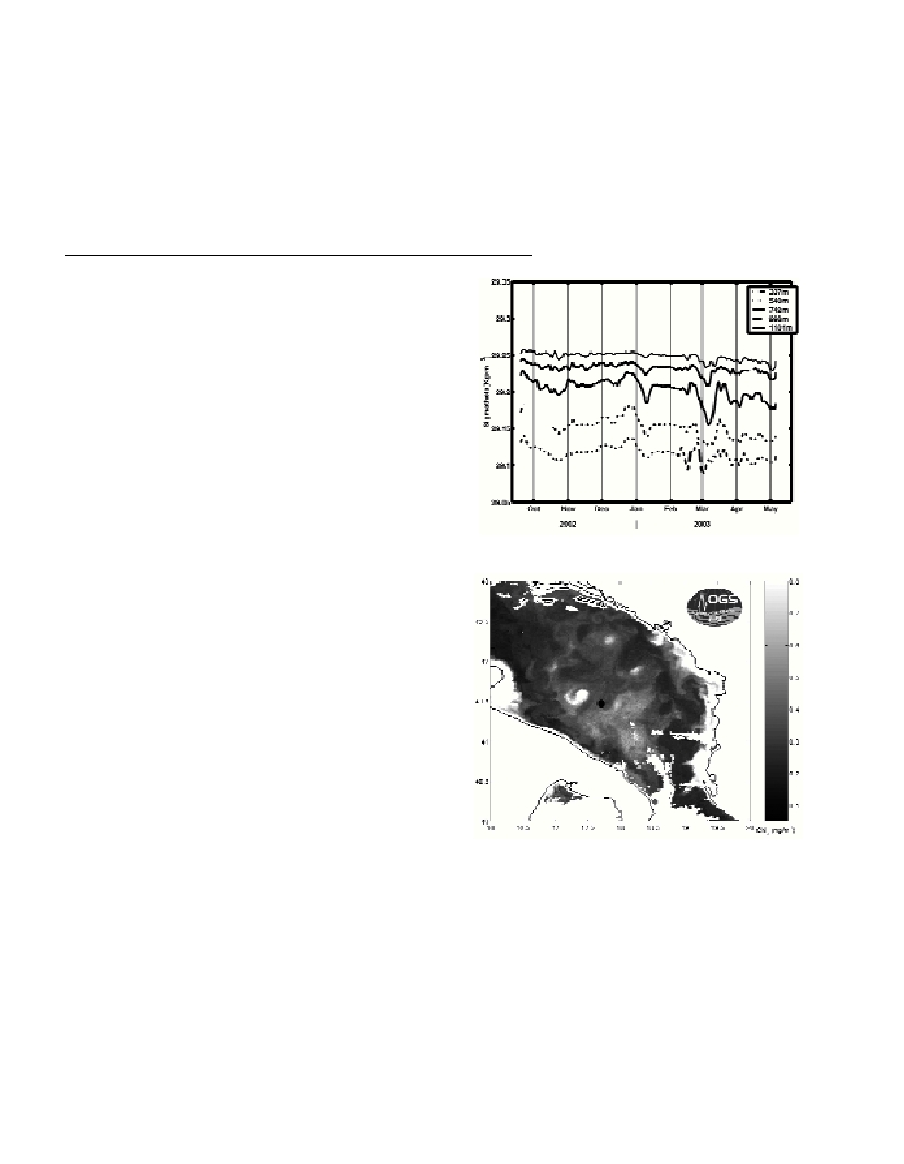
Low-pass filtered data of the potential density (Fig. 1) show rather
smooth temporal variations of the density field in the period from
October to December. From the end of December until the end of
March the density variations are characterized by the occurrence of
several events of sudden density decrease of the duration of about a
week. These density variations are associated with the occurrence of
the saltier and warmer water at the mooring site. The amplitude
maximum of these events occurs at a depth of about 700 m. The
vertical stratification variation is negligible during the entire studied
period demonstrating that, at least at the mooring site, the vertical
convection did not take place. Conversely, XBT surveys carried out on
a monthly basis in the area during the same winter do show that the
vertical convection took place in the Southern Adriatic area and
reached the horizon of about 600 m. The only possible explanation for
the lack of the vertical convection signal at the mooring site is that it
was located out of the vertically mixed patch. Indeed from the
SeaWiFS chlorophyll a horizontal distribution (Fig. 2) it is evident
that the mooring was positioned northward of the high-chlorophyll
patch. Presumably the high surface chlorophyll content corresponds
to the vertically mixed patch since in that area the nutrients available
for phytoplankton have much higher concentrations being brought to
the surface by the vertical mixing. Furthermore, the events of strong
density variations can be explained in terms of passages of mesoscale
eddies formed along the rim current of the patch as evident from the
chlorophyll distribution. These eddies are responsible for the water
properties advection and re-distribution from the patch into the rest of
the basin and have length scales of several tenths of kilometre.
Acknowledgments. We thank Elena Mauri for processing-
producing the SeaWiFS image and Isaac Mancero-Mosquera for the
help in processing-drawing the data.
Fig. 1. Time-series of potential density at five measurement depths.
Fig. 2. Horizontal distribution of the surface chlorophyll a concentration
(SeaWiFS data) for 16 April 2003. The mooring site is denoted by a thick dot.
References
1-Gacic M., Lascaratos A., Manca B.B. and Mantziafou A., 2001.
Adriatic deep water formation and interaction with the Eastern
Mediterranean Sea Pp.111-142. In: Physical Oceanography of the Adriatic
Sea, B. Cushman-Roisin et al.(eds.), Kluwer Academic Publishers.
2-Cardin, V. and Gacic M., 2003. Long-term heat ?ux variability and
winter convection in the Adriatic Sea. J. Geophys. Res.,108, C9: 8103.
3-Gacic, M., Civitarese G., Cardin V., Crise A., Miserocchi S. and
MauriE., 2002. The open-ocean convection in the Southern Adriatic: a
controlling mechanism of the spring phytoplankton bloom. Cont. Shelf
Res.,22, 14: 1897-1908.