ATMOSPHERIC CONDITIONS DURING SEVERE WAVE STORMS IN THE NORTH-WESTERN
MEDITERRANEAN. GENERATION, EVOLUTION, DECAY AND IMPLICATIONS
Jordi Cateura
1
*, AgustÌn S·nchez-Arcilla
1
, Rodolfo BolaÒos-Sanchez
1
, Abdel Sairouni
2
1
Laboratri díEnginyeria MarÌtima, LIM-CIIRC DEHMA. ETSECCPB Universitat PoltËcnica de Catalunya
C/Jordi Girona, 1-3, MÛdul D-1, Campus Nord, 08034, Barcelona, Spain
* jordi.cateura@upc.es, agustin.arcilla@upc.es, rodolfo.bolanos@upc.es
2
Servei MeteorolÚgic de Catalunya, c/BerlÌn 38-46, 08029, Barecelona, Spain - asairouni@meteocat.net
Abstract
In this paper, data from weather charts, meteorological stations and waverider buoys are used to analyse the atmospheric conditions during
two severe wave storms in the Catalan coast. Through the analysis of the development of the two severe wave storms, some common
characteristics have been identified. This allows the future forecast of similar occurrences and gains in understanding for improving
numerical wave forecasts.
Keywords: wave storms, wind waves, wave modeling, wave climate
Rapp. Comm. int. Mer MÈdit., 37,2004
90
The considered severe wave storms [1] have been the two most
energetic measured by the XIOM (Xarxa díInstruments
Oceanogrýfics i MeteorolÚgics) network since operational wave
prediction started as a joint venture between UPC-SMC (Universitat
PolitËcnica de Catalunya-Servei MeteorolÚgic de Catalunya). The
analysis has been done using mean sea level pressure charts from
MetOffice, 500 hPa geopotencial and wind field results from the
meteorological model GFS (Global Forecasting System) [2]. The
observations come from waverider buoy in Tortosa Cape (50 m depth)
and some meteorological stations from the XMET (Xarxa
METeorolÚgica) network deployed along the Catalan coast.
The first wave storm (November 9
th
and 17
th
2001) resulted from
the intense high pressure Atlantic center, moving toward the British
Islands. This causes first, a strong entrance of N and NE air ?uxes in
the NW Mediterranean. Nevertheless, the waves had significant wave
height (Hs) of 2.0 m from the NW, according to the wind direction
in?uenced by the orographic effect of the Ebreís valley (NW-SE). The
wave field direction de?ects towards NE, reaching 3.0 m Hs (although
the wind direction remains from the NW). Then the cold air
contribution, especially in atmospheric high levels (500 hPa),
develops a low in the Balearic Sea supported by the relatively warm
autumn sea. By the 11
th
, the wave field takes an E direction and
reaching 5.5 m Hs in the Ebreís Delta region. The quick movement of
the low-pressure center turns the wind to NE and N (NW direction in
Ebreís Delta). However, the wave field remains E towards with Hs
higher than 3.0 m, but losing height and turning to NW in the Tortosa
Cape. Cold air ?uxes from the N feeds the low-pressure center,
leading to an intense gradient for some days in the Genova Gulf.
Later, the high-pressure center moves to the British Islands which
induces NE and E air ?uxes.
The wave field de?ects to E with 5.9 m Hs (the highest recorded in
10 years). The lowís feeding is then interrupted with a transversal
position of the high level pressure. However, air ?uxes from NE and
E with large fetch persists. This sequence keeps a NW strong wind in
the Ebreís Delta area, and NE and E moderate, although persistent
winds during several days, in NW Mediterranean Sea. This situation
ended when the high pressure center moved back to an oceanic
position, stopping the eastern air ?uxes on the Catalan coast.
The second wave storm (March 28
th
and April 13
th
2002) was not
a single storm but a sequence of 3:
1. The initial one, with a blocking anticyclone moving from the
British Islands towards the Center of Europe. There was a strong wind
?ux (79.6 km/h in Porbou, 77.8 km/h in Barcelona, 65.5 km/h in Illa
de Buda) from E with a long fetch which inducing eastern waves with
3.0 m Hs. This situation lasted for 4 days.
2. Undefined surface pressure configuration co-existing with a
trough in the 500 hPa geopotencial level. This situation is prone to
ciclogenesis in the Mediterranean area, which ends up by generating
a subtropical low in the Alboran Sea. Wind and waves appear as a
response to the low center movement towards Italy. A high variability
in wind and in wave field can be observed. The new wave storm
evolves from S-E mild winds to moderate NE that becomes NW in the
Ebreís Delta area. The corresponding wave field reached 3.0 m Hs
with E direction. The low dissipates in 4 days.
3. A high level cold air pool deepening generates a new surface low,
affecting the whole NW Mediterranean littoral area during 3 days,
leading waves coming from the E and reaching 3.0 m Hs.
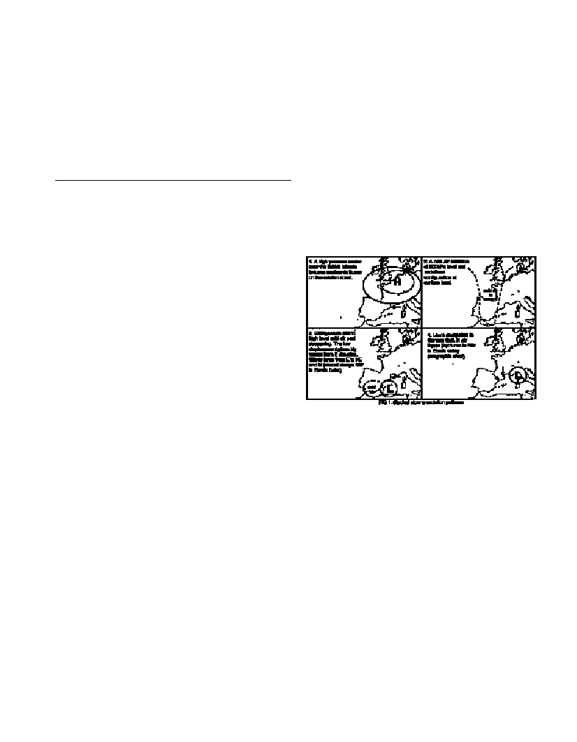
After the analysis of both storms it is possible to assume that this
type of configuration is favorable for triggering such events since both
had a similar pattern (Fig.1). That the E winds are responsible for the
highest energy seas on the Catalan coast, as could be expected.
However the conditions of both severe wave storms are the result of
synoptic situations that flow in this E direction on the NW
Mediterranean. The common synoptic configuration features are:
ï The initial positioning of an intense high-pressure area on the
British islands, leading to the NE and E air ?uxes on the Catalan
littoral.
ï Mediterranean ciclogenesis due a to high level cold air pool
deepening and the passage of the resulting low in front of catalan
littoral. It generates E winds, except in Ebreís Delta area where the
wind is coming from the NW due to orographic effects.
These results suggest a more detailed study of wave storm
development on the Catalan coast is necessary. It is evident that they
are associated to strong eastern events. However it is not well known
which synoptic atmospheric situations support such wind fields.
Moreover, it is necessary to analyze whether the most significant wave
storms always follow the same pattern. In order to provide an index
that allows an early warning for such situations with several days of
anticipation, well outside the time resolution of operational wave
models (WAM) [3].
References
1-BolaÒos-Sanchez, R., Sanchez-Arcilla, A., Gomez, J., Vilaclara, E.,
Sairouni, A. 2003. Prediccion de sucesos extremos en la costa Catalana,
VII Jornadas espaÒolas de Ingenieria de Costas y Puertos. Almeria 22-23
Mayo.
2-Kanamitsu, M., 1989. Description of the NMC global data
assimilation and forecast system. Wea. and Forecasting, 4: 335-342.
3-The WAMDI Group, 1988. The WAM Model:-A Third Generation
Ocean Wave Prediction Model, Journal of Physical Oceanography,
18:1775-1810.