Rapp. Comm. int. Mer Médit., 37,2004
97
COMPARISON OF SEA LEVEL CHANGES IN THE LAST DECADE IN THE MEDITERRANEAN SEA USING
SATELLITE ALTIMETRY VS TIDE GAUGE DATA
Luciana Fenoglio-Marc
1*
, Dov S. Rosen
2
1
Institute of Physical Geodesy, Darmstadt University of Technology, Petersenstrasse 13, D-64287 Darmstadt, Germany
* de1m@hrzpub.tu-darmstadt.de,
2
Israel Oceanographic and Limnological Research, Tel Shikmona, POB 31080, Haifa 31080, Israel - rosen@ocean.org.il,
Abstract
Sea level change has been measured over the last ten years using both tide gauge and altimetry. Only decadal and higher frequency sea
level changes are studied using altimetry, due to its shorter time interval of data availability, while the lower frequency variations are
investigated using tide gauge data. Altimetry from the Topex Poseidon mission and tide gauge time-series are compared in the time and
frequency domains at a number of stations in the Mediterranean Sea. A good agreement is found between the decadal, the interannual and
the seasonal components of the variability and three regions with different characteristics are identified in the Mediterranean. Linear trend
of the sea level height differences of monthly and instantaneous sea level heights are interpreted as potential vertical land movements.
Keywords: sea level change, tide gauge, altimetry
Introduction
Global coverage and sea level measurements in a given reference
frame are characteristics that distinguish altimetry from tide gauge
measurements. For altimetry the sampling is denser in space but less
dense in time at a given location and the available data span is shorter
than for tide gauges. Topex-Poseidon (T/P) data are available since
September 1992 with a 10-day time sampling rate, and 300 km
spacing at the equator. Long-term sea level changes have been mainly
investigated using T/P data [1] and ERS data [2]. The multi-mission
altimetry requires a careful cross-calibration of the missions and
homogenization of the corrections [3]. At present T/P provides the
longest and uninterrupted dataset. Interannual to decadal sea level
variations are estimated in the Mediterranean Sea over the interval
from September 1992 to July 2002 from T/P altimetry data and from
tide gauge monthly averaged data. At a few locations where hourly
data are available, sea level heights at the times of the closest
approach with the tide gauge sites are also compared and a linear
trend in the differences is estimated.
Annual to decadal variations
The sea level anomalies are averaged in monthly grids with spacing
of 1 x 1 degree using a Gaussian weighted average method with the
half-weight parameter equal to 1 and the earth radius equal to 3
degrees. The inverse barometric correction is not applied to the
altimetry data, while ocean, load and earth tide are applied. For each
time-series in the grid nodes, the linear-term (decadal variability), the
average variability over each month (seasonal variability) and the
interannual components of the variability contained in the power-
spectrum of the residuals are estimated. The decadal term is small in
the western Mediterranean (a few mm/yr) and higher with positive
values in the eastern Mediterranean (up to 8 mm/yr) and with negative
values in the Ionian Sea (up to –12 mm/yr). The decadal component
of sea level variability has a high correlation with decadal components
of sea surface temperature and steric height change. The dominant
frequency of the interannual part of the variability is different in the
eastern and in the western Mediterranean. The comparison between
the altimetry and the tide gauge results shows a good agreement
between the decadal component of the sea level variability, while the
cross-spectrum of the interannual variability shows a better agreement
in the eastern than in the western Mediterranean.
Linear variability of altimetry versustide gauge data
By differencing records from altimetry and tide gauge data, most of
the coherent sea level variability is removed and the residual time
series represents the Vertical Land Motion (VLM) at the tide gauge
site together with any instrumental errors, such as datum shifts and
data spikes in the tide gauge data and bias and drift in the altimeter
data. By differencing records from adjacent stations, the differential
VLM of the stations and the differential sea level variability is
obtained. Differences between tide gauge sea level heights and
altimetry derived sea level heights are computed separately using
monthly averaged values and interpolated hourly averaged tide gauge
data versus instantaneous altimeter sea level data at the time of the
closest altimeter approach. In this last case, the ocean tide correction
was not applied to the altimetry data, therefore the differential sea
level variability due to currents and tides remains in the difference.
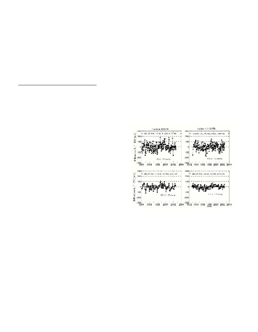
The results are represented in Figure 1 for the stations of Toulon
(SIMN) in the western Mediterranean and of Hadera (MedGLOSS) in
the eastern Mediterranean. The linear-term of the sea level height
differences is here of main interest. The small standard deviation of
the differences and the high correlation coefficient show a good
agreement of the data. The sea level height differences are used to
assess the data quality and to estimate relative biases and drifts
between the altimeter instruments as well as vertical land movements.
A bias estimation of each altimeter mission relative to the geocenter
requires collocated GPS measurements at the tide gauge station.
Fig. 1. Sea level height differences of hourly (above) and monthly
(below) sea level heights at the tide gauge stations of Hadera and
Toulon.
Acknowledgment. The authors acknowledge Aviso, SONEL and
IOLR for the data provided. Part of the study was performed under the
ESEAS-RI project No. EVRI-CT-2002-40025 under FP5 of the
European Commission.
References
1-Nerem S., Mitchum G., 2001. Sea level change, in Satellite Altimetry
and Earth Sciences, International Geophysics Series, Vol. 69, Academic
Press, San Diego, pp. 329-349.
2-Fenoglio-Marc L. 2002. Long-term sea level change in the
Mediterranean Sea from multi-satellite altimetry and tide gauges, Physics
and Chemistry of the Earth, pp. 1419-1431.
3-Fenoglio-Marc L., Groten E. 2003. Cross calibration of the Envisat
range using multi-mission altimetry and tide gauges in the Mediterranean
Sea, in Proceedings of the Envisat calibration, ESA.