Rapp. Comm. int. Mer Médit., 37,2004
98
SURFACE SALINITY MEASURED BY AN AIRBORNE MICROWAVE RADIOMETER
IN THE NW MEDITERRANEAN
C. Gabarró
1*
, J. Font
1
, J. Miller
1,2
1
Institut de Cičncies del Mar. CSIC. Passeig Marítim 37-49, 08003 Barcelona, Spain - *cgabarro@icm.csic.es, jfont@icm.csic.es
2
U.S. Office of Naval Research, London, UK. jmiller@onrifo.navy.mil
Abstract
SMOS (Soil Moisture and Ocean Salinity) is a satellite mission of the European Space Agency (ESA) to be launched in 2007. One of its
goals is the generation of global Sea Surface Salinity (SSS) maps. SMOS will carry an L-band (1.4 GHz) interferometric radiometer with
full polarimetric capability. The airborne EuroSTARRS campaign was sponsored by ESA in 2001 to provide land and ocean data for the
scientific studies supporting the SMOS mission, in particular to acquire ‘SMOS like’data to advance in the knowledge of passive
microwave multi-incidence observations for various surfaces. Some results of the campaign in the NW Mediterranean are presented and
discussed here.
Keywords: Microwave radiometry, SMOS, Surface salinity
The EuroSTARRS campaign took place in November 2001 over
land and ocean sites in France and Spain (1). The STARRS (Salinity
Temperature and Roughness Remote Sensing) instrument (2) from the
US Naval Research Laboratory was ?own onboard a DLR (Germany)
plane. It is a pushbroom L-band (1400-1426 MHz) V-polarisation
radiometer that measures simultaneously brightness temperature (Tb)
in six crosstrack beams at different angles and builds a 2-D image as
the aircraft moves along track.
On November 21
st
the plane over?own the Casablanca oil platform,
near the shelf break 40 km off the Ebro river delta, in the NW
Mediterranean. Simultaneously the R.V. García del Cid was
measuring surface salinity and temperature following the ?ight line,
plus some vertical T and S profiles in the area (3). At the same time
another ESA campaign (WISE 2001) was taking place from that
platform, with a fully polarimetric L-band radiometer measuring Tb at
different incidence angles during one month, and several
meteorological and oceanographic moored buoys recording surface
data around the platform (4).
The objective of this work is to demonstrate that it is possible to
retrieve salinity from the radiometer measurements in the
Mediterranean, and to validate empirical and theoretical sea surface
emissivity models needed for the inversion of Tb into salinity. In the
past years, improved methods have been developed to model the
polarimetric emission of the sea surface for different SSS, SST and
surface roughness. However, these models have been developed or
tuned at higher frequencies than L-band, typically 19 and 37 GHz.
Using data acquired during WISE a new semi-empirical model was
derived by fitting the sensitivity of Tb to wind speed at different
angles. In (5) some of these models are presented and used to retrieve
SSS from data acquired during WISE.
The algorithm used to obtain salinity from Tb is the Levenberg-
Marquardt recurrent least square fit. It has been chosen for its easy
implementation and computational efficiency. Tb is computed setting
an initial guess for SSS into the direct emissivity model, and the
resulting value is compared with the Tb measured by the radiometer.
Then an increment (DSSS) is added to the initial salinity, the new Tb
is computed and compared again to measurement. This recursive
process is stopped when the difference between measured and
computed Tb is smaller than a specified threshold.
In situSSS measured during EuroSTARRS was quite constant, its
variability being below the sensitivity of the radiometer. The wind
speed was very low during the ?ight and an average value of 3.67 m/s
has been used in the computation. SST was measured by additional
infrared channels in STARRS. As the radiometric data were
significantly noisy, an average of the 800 Tb measurements recorded
during a straight ?ight in very similar atmospheric conditions have
been used in the retrieval.
Six different emissivity models have been tested, and retrieval
results compared with Casablanca in situ measurements. Semi-
empirical models provide better results than theoretical models, and
the best performances are obtained when using models derived from
WISE data. It has to be stressed that the latter correspond to similar
environmental and hydrographic conditions than during
EuroSTARRS, but were acquired by a radiometer of different
technology and situated much closer to the sea surface (4).
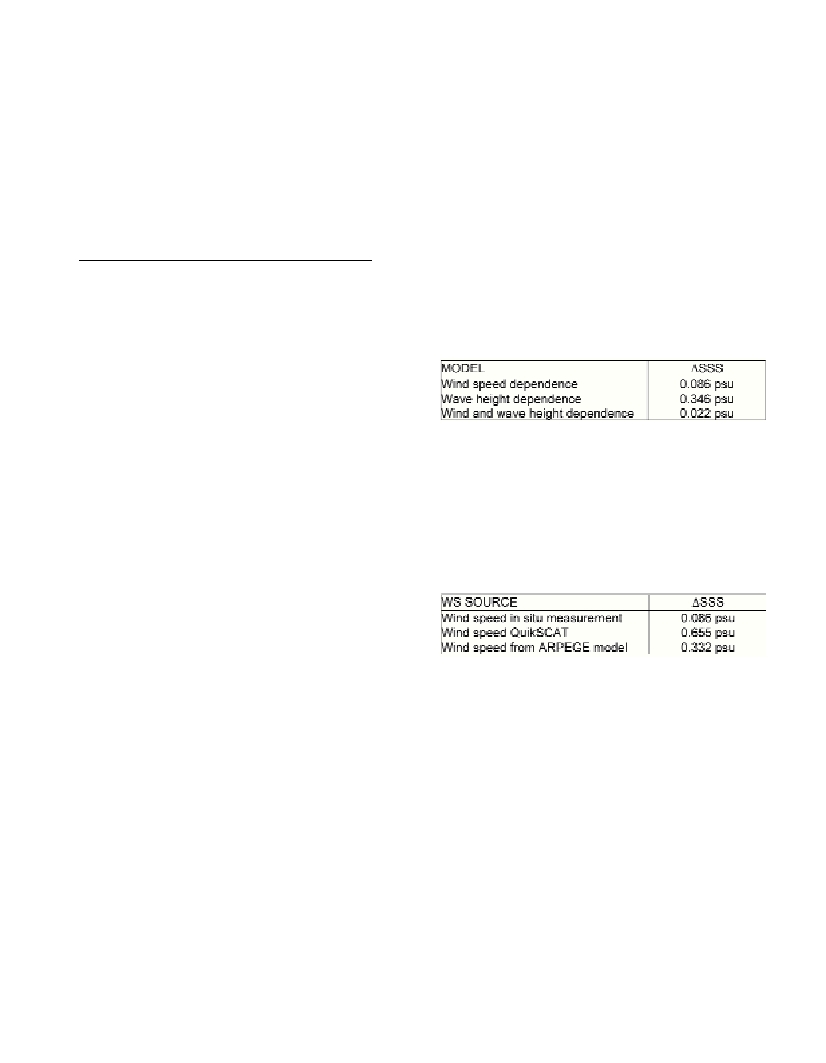
Table 1 presents the errors on the retrieved salinity using 3 different
semi-empirical models, all of them derived from WISE campaign
data: the first one is dependent on wind speed (WS), the second
dependent on significant wave height (SWH), and the third dependent
on both parameters. Results show that the best option is the joint
dependence on WS and SWH, since this model, in opposition to the
others, includes the effect on surface roughness of swell and not fully
developed wind seas.
Table 1. Comparison of different semi-empirical models.
?
SSS =
|
SSS
_
measured - SSS
_
retrieved
|
An open question for the SMOS mission, is how these auxiliary
parameters (WS and SWH), necessary for the SSS retrieval, will be
obtained all over the world oceans. Table 2 shows the errors on the
retrieved salinity in the EuroSTARRS case produced by errors on the
wind speed measurements using the semi-empirical model dependent
only on WS. Additionally to in situ data two different sources for wind
speed information have been analysed: QuikSCAT satellite
scatterometer and ARPEGE (MétéoFrance) atmospheric model. Both
have similar spatial resolutions, but the temporal resolution is much
higher for the model (6h) than for the satellite (3 days).
Table 2. Errors in retrieved salinity when using different sources for wind
speed.
It appears that small errors on WS (nominal error for the model is
2m/s) produce large errors on the retrieved salinity. The better results
with ARPEGE output than with QuikSCAT measurements is probably
related to the different temporal resolution.
References
1-Berger M., Camps A., Font J., Kerr Y., Miller J.L., Johannessen J.,
Boutin J., Drinkwater M.R., Skou N., Floury N., Rast M., Rebhan H.,
Attema E., 2002. Measuring ocean salinity with ESA’s SMOS mission –
Advancing the science. ESA Bull-Eur Space, 111: 113-121
2-Miller J.L., and Goodberlet M., 2003. Development and application of
STARRS – a next generation airborne salinity imager. Intl. J. Remote
Sensing, accepted.
3-Emelianov M., Font J., Juliŕ A., Gabarró C., LLoret M. and Solé J.,
2003. Sea surface fiels at Casablanca site (NW Mediterranean) during the
EuroSTARRS campaign. Proceedings of the WISE/LOSAC/EuroSTARRS
Campaigns Workshop,ESA SP-525: 73-80
4-Camps A. , Font J., Vall-llossera M., Gabarró C., Villarino R., Enrique
L., Miranda J., Corbella I., Duffo N., Torres F., Blanch S., Arenas J., Juliŕ
A., Etcheto J., Caselles V., Weill A., Boutin J., Contardo S., Niclňs R.,
Rivas R., Reising S.C., Wursteisen P., Berger M. and Martín-Neira M.,
2003. The WISE 2000 and 2001 campaigns in support of the SMOS
mission: Sea surface L-band brightness temperature observations and their
application to multi-angular salinity retrieval. IEEE Trans. Geosci. Remote
Sensing, in press
5-Gabarró C., Vall-llossera M., Font, J. and Camps, A., 2003.
Determination of sea surface salinity and wind speed by L-band
microwave radiometry from a fixed platform. Intl. J. Remote Sensing, 24,
in press.