Rapp. Comm. int. Mer Médit., 37,2004
99
Introduction
Free surface, sigma coordinate ocean models are being used for a
variety of applications, ranging from small-scale process studies and
coastal and estuarine modelling and prediction to basin-scale ocean
circulation and climate change modelling. It is important to evaluate
the sensitivity of the model and enhance its predictive capability as to
help users choose the best parameters for their particular applications.
This study uses independent information collected from satellite
platforms to improve and spatially verify the forecasting accuracy of
small-scale predicted oceanic fields.
Method
The ocean model is the P
rinceton O
cean M
odel (POM) with a
domain starting from 15.8
o
E and 33.24
o
N with 82 grid points in the
east-west direction, and 61 grid points in the north-south direction.
The grid spacing in degrees is 0.042
o
with 24 sigma levels. The model
bathymetry used is the US Navy Digital Bathymetric Base. The lateral
boundary conditions were from MODB MED4. Sets of daily, 3-hourly
surface fields were generated from a high-resolution atmospheric
model working over the same domain and horizontal resolution and
used to force the ocean model at the surface. SST was derived from
the Tropical Microwave Imager at a nominal resolution of 0.25
o
and
re-interpolated over the model’s domain grid.
A hind-cast forecasting sequence was started with zero velocity on
1
st
July 1999 and continued in forecasting mode for an additional 20
days. No forcing of the surface boundary conditions was performed.
The 3-D oceanic fields were dynamically adjusted to a constant SST
field derived by the TMI on the 22
nd
of July 1999 at approximately
00UT. The actual model forecasts started on July 22
nd
at 1200 hrs
with daily atmospheric forcing and consecutively every integration
day until the 5
th
of August. The model was initialised using remotely-
sensed SST. This information was propagated down to the vertical
model prognostic fields. Two data assimilation (DA) experiments
were performed to assess the effectiveness on the accuracy of the
forecasted SST:
1. varying the nudging period during which the model fields are
dynamically nudged towards the SST observations. Three scales were
tested: 06, 12 and 24 hours.
2. including a second forcing, nudging coefficient, to nudge the
model fields towards the SST observations. Four coefficients were
tested 5x10
-3
, 5x10
-4
, 5x10
-5
and 5x10
-6
for each of three nudging
periods.
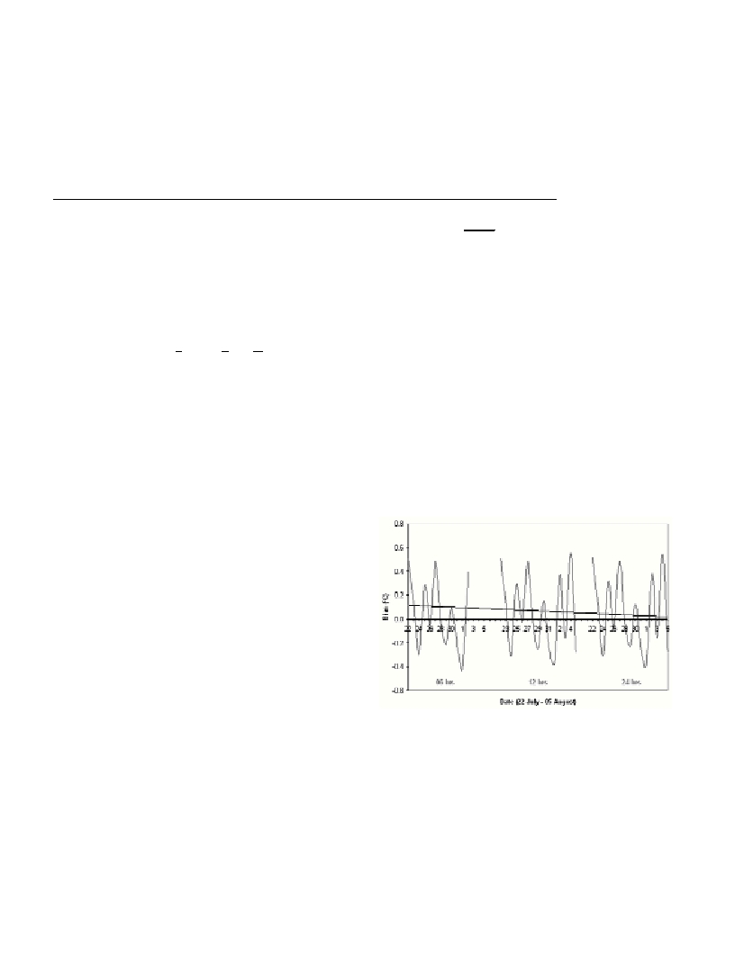
Results and discussion
The first data assimilation scheme leads to the most accurate
predictions of the SST. The best nudging period is 24 hours, giving a
mean bias over the entire 15-day model integration of only –0.05
o
C
against remotely sensed data. It is interesting to note that Horton et.
al., applied a similar DA scheme for their ocean forecasting system
that assimilated AVHRR MCSST [1]. The new SST values were
assimilated by the model using a nudging period of only 4 hrs.
The inclusion of an additional coefficient in the equation leads to
strong nudging towards the initial observations. The optimal nudging
coefficient is found to be 5x10
-4
for 06 hours, giving a mean bias of
–0.08
o
C.
Despite the small period of evaluation, some general remarks can
be made. What is evident from this study is that an active data
assimilation scheme tends to dampen the ?uctuating bias tendency.
The temporal ?uctuation in the bias trend is caused by the model’s
attempt to equilibrate the model dynamics towards the prognostic SST
values. However, its resilience or degree of damping is seen to be
dependent on the two factors that regulate the extent of this
?uctuation:
the relaxation time and nudging coefficient K
q
.
This treatment leads the model to show a better performance than
other ocean forecasting systems used in the region. Nittis et. al.,for
example, obtained a bias of 0.1 to 0.8
o
C when their 24-hour POM-
forecasted SST was compared to collocated in situbuoy
measurements [2].
High-resolution sea surface thermal signature observed by AVHRR
confirmed the ability of the improved ocean model to predict sub-
basin surface circulation. The small-scale SST pattern is shown to be
set by a balance of atmospheric (provided by the high resolution,
atmospheric model) and oceanic processes (provided by the high
resolution POM), including wind-driven mixing, atmospheric heating
and cooling, and horizontal and vertical advection in the ocean.
Predicted ocean fronts are found to be collocated with atmospheric
convergences as predicted by the atmospheric momentum stress over
the geographical area. The AVHRR sensor reveals filaments and jets
near these fronts.
The use of one-way atmosphere-ocean coupling offers distinct
advantages over current basin-wide forecasting systems. Recent
studies in the Mediterranean utilise bulk formulae to compute the
surface boundary conditions of the ocean models [3]. Atmospheric
variables, such as wind field, air temperature and relative humidity are
derived from coarse, monthly averages of 12-hour NCEP analyses for
the period 1980-1988.
Fig. 1. Bias trends of 24-hr predicted SST using a varying nudging peri-
od (lower text in graph).
References
1-Horton, C., M. Clifford, J. Schmitz, and L. Kantha, 1997. A real-time
oceanographic nowcast/forecast system for the Mediterranean Sea. J.
Geophys. Res., 102, 25: 123-25,156.
2-Nittis K., Zervakis V., Perivoliotis L., Papadopoulos A. and Chronis G.,
2001. Operational Monitoring and Forecasting in the Agean Sea: System
Limitations and Forecasting Skill Evaluation. Marine Pollution Bulletin,
Vol. 43, Nos 7-12: 154-163.
3-Lascaratos, A. and K. Nittis, 1998. A high-resolution three-
dimensional numerical study of intermediate water formation in the
Levantine Sea. J. Geophys. Res.,103 (C9): 18497-18511.
t
q
el
mod
?
?
IMPROVING THE PREDICTION OF AN OCEAN MODEL USING NOVEL REMOTE SENSING DATA
Charles Galdies
International Ocean Institute, University of Malta, Msida, Malta
Abstract
Novel satellite SST is assimilated into a high-resolution primitive-equation ocean model to improve the simulation of surface ocean
processes linked to the air-sea interactions at sub-mesoscale level. A high-resolution ocean model over the Ionian basin is used to provide
short-range forecasts of the ocean state. The model is initialised using high-resolution air-sea ?uxes generated by a high-resolution
atmospheric model. An assimilation scheme using SST derived from the Tropical Microwave Imager is optimised to improve the ocean
forecasting skill. Validation is performed over a 15-day model integration window.
Keywords : Tropical Microwave Imager, Newtonian nudging, Sea surface temperature, Princeton Ocean Model