Rapp. Comm. int. Mer Médit., 37,2004
106
THE SURFACE CIRCULATION IN THE EASTERN BASIN OF THE MEDITERRANEAN SEA
N. Hamad, C.Millot* and I. Taupier-Letage
Antenne LOB-COM-CNRS, BP 330, F-83507 La Seyne-sur-Mer, France - * cmillot@ifremer.fr
Abstract
The Atlantic Water (AW) circulation schemata widely referred to nowadays (1, 2, 3) represent a cross-basin meandering jet, thus
disagreeing with a pioneering work (4) and a former analysis of IR images (5, 6). A roughly similar controversy was elucidated in the
western basin where this imagery was proven reliable. This has motivated the visual analysis of daily/weekly (~1000, 1996-2000) and
monthly (since 1985) composites. In our schema, the mean ?ow is anticlockwise along the upper part of the continental slope and it
generates mesoscale eddies that tend to follow the deeper isobaths. Other eddies are induced by the Etesians every year. All eddies can
have several-year lifetimes, propagate and merge.
Key-words: Mediterranean Sea, eastern basin, IR imagery, surface circulation, mesoscale eddies
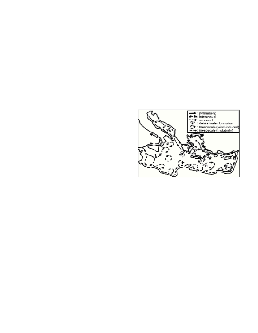
Overall, the AW circulation (100-200 m thick) is alongslope and
anticlockwise. It is permanent from Tunisia to Turkey and seasonally
variable in the Aegean, the Ionian around Greece and the Adriatic. A
branch, having spread for years (up to early 1998) from the Sicily
channel towards the northern Ionian before vanishing, represents
interannual (not seasonal) variability. Mesoscale eddies, generated by
the instability of the AW ?ow or by orographic effects on the Etesians,
were not correctly described before. Although they have
characteristics almost specific to each subbasin and/or to their
generation mechanism, the largest are anticyclonic, reach diameters of
a few 100s km and can be tracked for months/years propagating at up
to a few km/d . They represent a relatively large amount of AW and
play a fundamental role in spreading it seaward.
In the southern Ionian, large eddies generated by the AW ?ow as
soon as the depth exceeds a few 100s m seemingly drift along
intermediate to deeper isobaths, probably depending on their vertical
extent. An eddy, initially found east of Sicily, drifted southwards as far
as Libya where it disturbed the AW alongslope ?ow more than two
years later. All eddies originated either in the north (including Pelops)
or in the south can drift in the central Ionian and create there a
complex eddy-field that, being only partially investigated, was
incorrectly associated with the alleged “Atlantic Ionian Stream” and
“Mid-Ionian Jet”. On average, AW does not cross the Ionian in its
central and/or northern parts but ultimately concentrates in the south
as an alongslope anticlockwise ?ow that is unstable and generates
anticyclonic (Libyan) eddies.
These eddies then propagate downstream along the eastern Libyan
slope and eventually interact with Ierapetra, thus increasing the
interannual variability of the latter. In addition, Ierapetra can remain
stationary more than one year and thus be intensified the year after, it
can drift over 100s km, merge with a former Ierapetra and / or reach
the Libyan and Egyptian slopes; hence, successive Ierapetra’s can be
found simultaneously. At the entrance of the Levantine, the largest
Libyan eddies tend to follow the deeper isobaths and thus detach from
their parent current. Then, together with Ierapetra, they generally
remain trapped by the Herodotus trough before finally decaying.
Contrary to what has been believed hitherto, the “Mersa-Matruh” area
(named
S
L
W
) is occupied not by a recurrent / permanent feature but
by slowly propagating and merging anticyclonic eddies originated
elsewhere. The northwestern edges of such mesoscale eddies must
have been confused with a northeastward “Mid-Mediterranean-Jet”.
The specificity of that area is thus due to processes never foreseen
before.
The Shikmona area (named
S
L
E
) is occupied by an offshore
anticyclonic structure fed by various kinds of small-scale eddies
originated alongslope. Both the “Cilician Current” and the “Asia
Minor Current” are the continuity of the overall alongslope ?ow that
meanders and generates medium-size eddies. The ?ow continues
either into the Aegean, especially in winter, or southwestwards, up to
feeding Ierapetra. North of Crete, most eddies propagate eastwards. In
the northern Ionian, the ?ow towards the Adriatic displays a marked
seasonal variability, intensifying in winter. In the Adriatic, it clearly
surrounds the dense water formation zone in winter.
The monthly-composite analysis confirms that an alongslope and
anticlockwise schema also applies to the late eighties - early nineties
at least. In addition, all features evidenced with all available in situ
data sets (in particular the POEM ones) can be seen with the IR
imagery. It is thus concluded that i) all available data sets are reliable
and ii) the POEM schemata (1, 2, 3) result from a misinterpretation of
the observed features. Although mainly descriptive, our visual
analysis of IR images allows proposing an alternative realistic schema
of the AW circulation. The mean ?ow is anticlockwise alongslope and
unstable. Mesoscale (100-200 km) anticyclonic eddies, propagate for
months/years at up to a few km/d and tend to follow the deeper
isobaths. An extended version of this paper is presently submitted to
Progress in Oceanography.
References
1-Robinson A.R., Golnaraghi M., Leslie W.G., Artegiani A., Hecht A.,
Lazzoni E., Michelato A., Sansone E., Theocharis A., and Ünlüata Ü.,
1991. The Eastern Mediterranean general circulation : features, structure
and variability. Dyn. Atm. Oceans, 15: 215-240.
2-Robinson A.R., and Golnaraghi M., 1993. Circulation and dynamics of
the Eastern Mediterranean Sea; Quasi-Synoptic data-driven simulations.
Deep Sea Res., 40: 1207-1246.
3-Malanotte-Rizzoli P., Manca B.B., Ribera d’Alcala M., Theocharis A.,
Bergamasco A., Bregant D., Budillon G., Civitarese G., Georgopoulos D.,
Michelato A., Sansone E., Scarazzato P., and Souvermezoglou E., 1997. A
synthesis of the Ionian Sea hydrography, circulation and water mass
pathways during POEM-Phase I. Prog. Oceanogr.,39:153 -204.
4-Nielsen J.N., 1912. Hydrography of the Mediterranean and adjacent
waters. Rep. Dan. Oceanogr. Exp. Medit., 1: 77-192.
5-Le Vourch J., Millot C., Castagné N., Le Borgne P., and Olry J.P., 1992.
Atlas of thermal fronts of the Mediterranean Sea derived from satellite
imagery. Mém. Inst. Océanogr. Monaco, 16.
6-Millot C., 1992. Are there major differences between the largest
Mediterranean Seas? Bull. Inst. Oceanogr. Monaco, 11: 3-25.