Rapp. Comm. int. Mer Médit., 37,2004
118
IS THE ALTERNATIVE LIW PATH BECOMING MORE IMPORTANT?
López-Jurado J.L.
1
, Vélez-Belchí P.
2 *
, González-Pola C.
3
, Vargas-Yáńez M.
4
1
Instituto Espańol de Oceanografía, C.O. de Baleares, Muelle de Poniente s/n, 07080 Palma de Mallorca, Spain - lopez.jurado@ba.ieo.es
2
Instituto Espańol de Oceanografía, C.O. de Canarias, crta de San Andrés Nş45, 38180 , S/C Tenerife, Spain - *pedro.velez@ca.ieo.es
3
Instituto Espańol de Oceanografía, C.O. de Gijón, Avda. Príncipe de Asturias 70 bis, 33212 Gijón, Spain - cesar.pola@gi.ieo.es
4
Instituto Espańol de Oceanografía, C.O. de Malaga, Puerto Pesquero de Fuengirola s/n,
29640 Fuengirola (Málaga), Spain - manolo.vargas@ma.ieo.es
Abstract
During July 2003, intense (38.60) signal of LIW was found south of the Balearic archipelago. Comparison with historical data shows as
this high LIW values in the Algerian basin have not been found before. This new data rise up the question about the importance of this
alternative path for the LIW transport into the western Mediterranean sea.
Keywords: LIW, Algerian Basin, circulation
The principal path of the LIW in the western Mediterranean sea is
following a cyclonic loop that begin in the strait of Sicily, surround
western Italy, Corcega Sardinia, the French coastline and the Spanish
one until they arrive to the Alborán Sea. Completing the loop some
waters also ?ow back eastward along the Algerian coastline. In spite
the many studies done in the Algerian Basin, a direct path of LIW
from the channel of Sardinia to the Alborán Sea have not been found,
neither Leddies due to the LIW vein becoming unstable near the
southwestern corner of Sardinia [1,2]. On the other hand, some data
corroborates the second route for the transport of LIW westward
through the Algerian basin. As hypothesized by [3], eddies from the
Algerian current could catch LIW near the Strait of Sardinia and drift
it westward. This overall circulation at intermediate depths is clearly
observed for the Algerian Basin in figure 1, where the distribution of
the salinity maximum for the historical data (Medatlas, 2002), with
the box delimitated by 0şW,8W and 38şN, is represented. The
maximum salinity is found in the neighbourhood of the Strait of
Sardinia (S>38.66), decreasing westward, with its axis along the
centre of the basin. This structure is associated with the secondary
route for the LIW [3],[4].
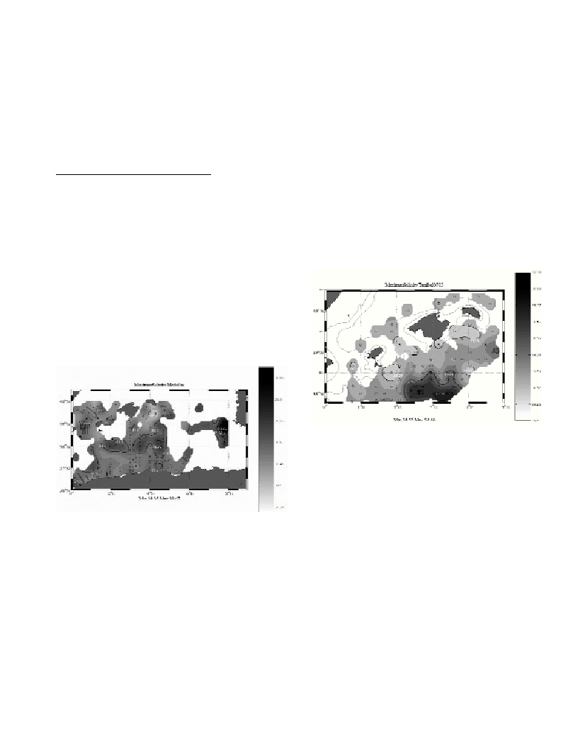
Fig. 1. Horizontal distributions of the salinity maximum for all CTD pro-
files from the Medatlas 2002 database found within the box delimited by
0şW-8W, 40şN and the northern African coast.
During July 2003 the Tunibal0703 survey was carried out, by the
Instituto Espańol de Oceanografía, on the waters surrounding the
Balearic Archipelago. CTD data during this survey was obtained with
a SBE-911+, and post-cruise calibration was carried out with salinity
bottles an a AutoSal-Guideline salinometer, yielding standard WOCE
accuracy for salinity. For redundancy two stations were carried out
with a SBE-25 attached to the SBE-911+, yielding differences within
the technical specifications of the sensors.
The intermediate circulation in the northern Algerian Basin during
Tunibal0703 shows a pattern of LIW with maximum salinity values
up to 38.60 and temperatures up to 13.6şC, as can be observed in
figure 2, where the distribution of the salinity maximum during that
survey is represented. The depth of this maximum is generally
between 300 and 600 Dbar. Southern than Mallorca the high salinity
values appear. The data in the upper layer (not shown), denote strong
anticyclonic circulation and waters of atlantic origin, therefore
indicating a possible source for these LIW: drifted from the strait of
Sardinia by an anticyclonic Eddie formed in the Algerian current. The
horizontal distribution of maximum salinity depth and dissolved
oxygen at this surface denote a frontal zone for clearly different LIW.
The importance of the data presented here resides in that this high
values have not been found before in the western Algerian basin.
Therefore, it could be that the role of this alternative LIW path were
more important as thought before, as indicated by the data gathered
during the similar surveys carried out in 2001 and 2002 summer,
where LIW salinities of 38.53 and 38.55 were observed in the same
area. Or even that the discussion of ‘Leddies’could be open again.
Fig. 2. Horizontal distributions of the salinity maximum found during
Tunibal0703.
References
1-Benzohra, M. and C. Millot, 1995. Characteristics and circulation of
the surface and intermediate water masses off Algeria, Deep-Sea Research
(Part I), 42: 1803-1830
2-Fuda, J. L., C. Millot, I. Taupier-Letage, U. Send, and J. M.
Bocognano, 2000. XBT monitoring of a meridian section across the
western Mediterranean Sea, Deep-Sea Research (Part I), 47: 2191-2218.
3-Millot, C., The circulation of the Levantine intermediate water in the
Algerian Basin. J. Geophys. Res., 92: 8265-8276.
4-Perkins, H. and P. Pistek, 1990. Circulation in the Algerian Basin
during June 1986. J. Geophys. Res., C.Oceans, 95: 1577-1585.