Rapp. Comm. int. Mer Médit., 37,2004
119
COASTAL GEOSTROPHIC FLOW IN THE NORTHEASTERN ADRIATIC: JUNE-SEPTEMBER 2003
Daniel M. Lyons *, Nastjenjka Supic, Nenad Smodlaka
Center for Marine Research, Rudjer BoškovicInstitute, G. Paliaga 5, 52210 Rovinj, Croatia - supic@cim.irb.hr
Abstract
High resolution CTD data collected during 18 cruises from June to September 2003 are used here to compute relative geostrophic currents
in the northeastern Adriatic coastal belt. Results indicate a strong southerly out?ow in the area throughout the whole period investigated,
suggesting a current that ?ows counter to the accepted general cyclonic circulation of the Adriatic.
Keywords: CTD, geostrophic circulation, northern Adriatic
Introduction
General Adriatic circulation consists of a cyclonic meander with an
in?ow along the eastern and out?ow along the western coast (1).
However, results of recent investigations indicate a more complex
system where a very strong out?ow can occur in the northeastern
coastal zone during the warm part of the year, near the Istrian
peninsula. These previous studies are based on direct current
measurements at several points in the area (2) or on analysis of
geostrophic currents derived from low resolution hydrographic data
collected monthly at several depths at two stations 24 km apart (3).
However, in order to describe the circulation pattern near the
northeastern coast of the Adriatic more precisely we report herein an
analysis of geostrophic currents, known to be a good approximation
of real currents in the area during the warm part of the year (4),
computed on the basis of fine resolution hydrographic data as a means
for determining the initial conditions before deep water formation
processes begin in autumn and winter.
Data and methods
CTD (SeaBird SBE 25) data were collected over a 19 station grid
during 18 cruises from June to September 2003 off the Istrian coast of
Croatia (Fig. 1). Geostrophic currents, relative to the 20 m depth level,
between each two neighboring stations were computed using standard
mathematical methods (3) and elaborated graphically using the ODV
software package.
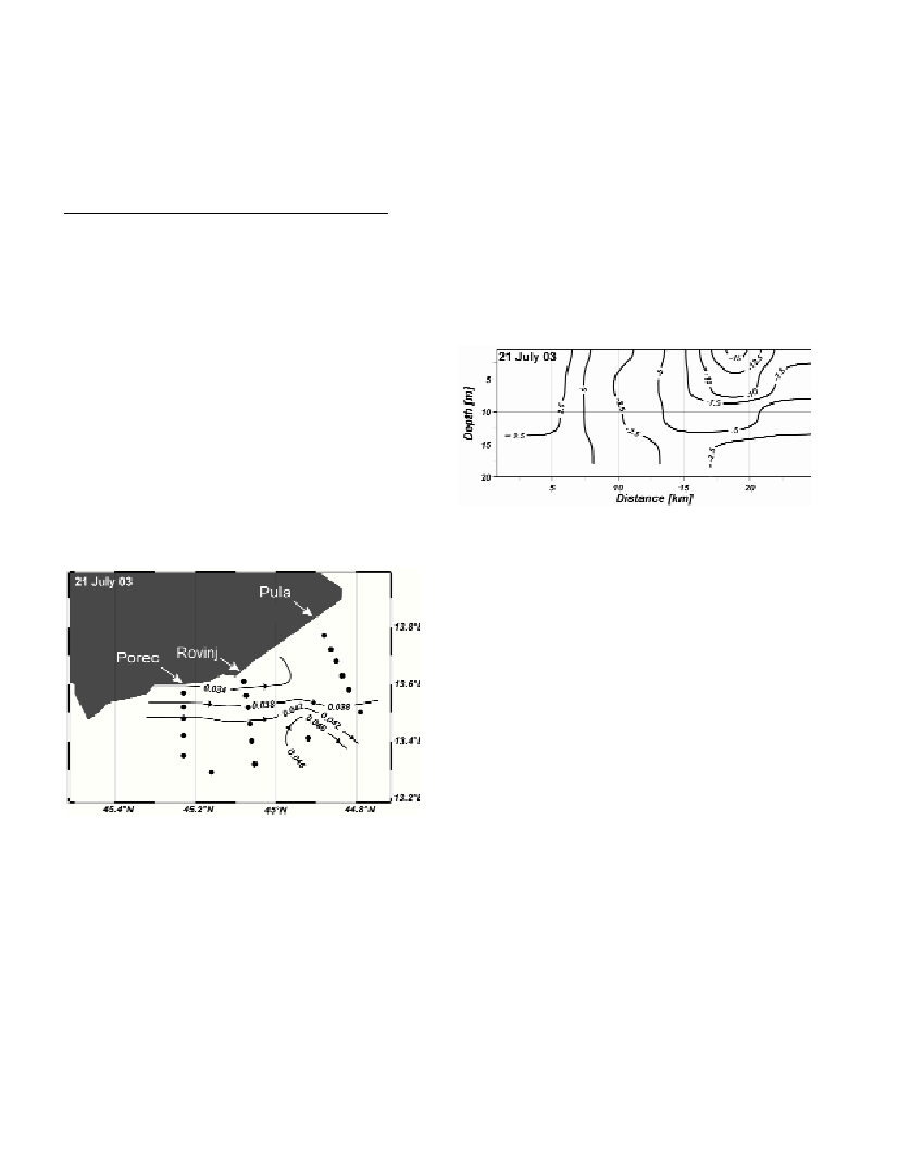
Fig. 1. Oceanographic stations and dynamic heights (dyn m) at 2 m depth
relative to the 20 m level.
Results
Dynamic height variations, represented as iso-lines at 2 m depth,
indicate a southerly out?ow throughout the period concerned, with
weekly variations in intensity and extent. On several occasions – as
for example on 21 July2003 - the out?ow was strong along the whole
western coast of the Istrian peninsula (Fig. 1). Generally, northward
movement of water was observed in vertical profiles at all depths
corresponding to the mesoscale cyclonic circulation of the Adriatic.
However, a southerly out?ow of water counter to the normal
circulation, localized to a layer extending from the surface to 15 m
depth and located close to the coast in a 10 km belt, prevailed at all
sections. Relative geostrophic velocities for the Porecand Rovinj
(Fig. 2) profiles typically attained values of about 10 cm s
-1
for
out?ow while in?ow velocities were about 2 cm s
-1
. Motions at the
Pula section were stronger (typically from 2-5 cm s
-1
for in?ow, and
10-20cm s
-1
for out?ow) compared to the other sections. This
indicates the appearance of a current moving in a southerly direction
in the coastal zone off Istria, previously named the Istrian Coastal
Countercurrent (ICCC; 3). It is held that the ICCC is part of a closed
anti-cyclonic circulation cell in the northern Adriatic in which waters
of Po origin are restricted (4). Unusually, this lower salinity pool was
also observed in northeastern Adriatic open waters in spring and
summer of 2003 in spite of exceptionally low Po discharge rates (D.
Degobbis, personal communication).
Fig. 2. Vertical profile of the Rovinj section showing relative geostroph-
ic velocities (cm s
-1
) with respect to the 20 m level. Negative sign
denotes southward ?ow.
Conclusion
Using high resolution temperature and salinity data in the interval
from June-September 2003 document in detail for the first time the
location, extent and relative magnitude of counter currents to the
normal circulation over a large area adjacent to the Istrian coast. Our
results show that during the interval concerned there was an almost
permanent, or highly prevailing, southerly anti-cyclonic alongshore
?ow in the region, becoming greater in magnitude towards the south,
and may bound a low salinity pool in the middle northern Adriatic.
References
1-Franco P., and Michelato A., 1992. Northern Adriatic Sea:
Oceanography of the Basin Proper and of the Western Coastal Zone. Sci.
Total Environ., Suppl.: 35-62.
2-Brana J.H., and Krajcar V., 1995. General Circulation of the Northern
Adriatic Sea: Results of Long-term Measurements. Estuar. Coast. Shelf
Sci.,40: 421-434.
3-Supic N., Orlic M., and Degobbis D., 2003. Istrian Coastal
Countercurrent in the year 1997. Nuovo Cim. C, 26: 117-131.
4-Krajcar V., Supic N., and Kuzmic M., 2003. Referencing geostrophic
velocities at a northern Adriatic section. Nuovo Cim. C., in press.