Rapp. Comm. int. Mer Médit., 37,2004
129
A CLIMATOLOGICAL SIMULATION FOR THE MIDDLE ADRIATIC COASTAL AREA
Mirko Orlic
(1)
, Gordana Beg Paklar
(2)
*, Branka Grbec
(2)
, Mira Pasaric
(1)
, Zoran Pasaric
(1)
(1)
Andrija Mohorovicic Geophysical Institute, Faculty of Science, University of Zagreb, Horvatovac bb, 10000 Zagreb, Croatia
orlic@olimp.irb.hr, mpasaric@rudjer.irb.hr, pasaric@rudjer.irb.hr
(2)
Institute of Oceanography and Fisheries, Set. I. Mestrovica 63, 21000 Split, Croatia - *beg@jadran.izor.hr, grbec@jadran.izor.hr
Abstract
Numerical model is designed and used to reproduce seasonal cycle of thermohaline and dynamical properties of the middle Adriatic coastal
area. Results of a three-year long experiment with perpetual atmospheric and riverine forcing reveal strong seasonal signal, which agrees
with temperature and salinity data originating from the permanent oceanographic stations along Split-Gargano transect and with some
early current measurements.
Keywords: numerical model, seasonal cycle, Adriatic Sea
Introduction
High-resolution oceanographic model, called ASHELF-2, was
developed for the middle Adriatic coastal area and was used to
simulate its climatological characteristics. Successful simulation of
the climatological variability of the thermohaline and dynamical
properties is needed as a starting point for the reliable oceanographic
short-term forecast of the studied area.
The ASHELF-2 model is nested into the whole-Adriatic model
(AREG) (1) and is run with the perpetual atmospheric and riverine
forcing. Numerical model results are compared with climatological
temperature and salinity data obtained at permanent oceanographic
stations and with some early current measurements in the area (2).
Model setup
The oceanographic model used is modification of the Princeton
Ocean Model (POM) (3). The ASHELF-2 model uses the grid of
constant horizontal resolution of 1 km, which covers the studied area
with 189x106 points. Along the vertical, 16 sigma levels were defined
with finer distribution near the surface and bottom.
The oceanographic model was forced with monthly varying fields
of surface momentum, heat and water ?uxes and monthly discharges
from four rivers: Jadro, Zrnovnica, Cetina and Neretva. Surface heat
?uxes diagnosed by AREG were linearly interpolated onto the
ASHELF-2 grid and corrected during ‘perpetual year’simulation to
produce seasonal climatology using ATOS data set (1). Surface water
?uxes, computed from evaporative heat ?ux, precipitation data and
monthly runoff from four rivers discharging into the ASHELF-2
domain, were also corrected during simulation to produce seasonal
climatology and to avoid the excessive freshening of the basin that
could result from the use of the climatological forcing.
At both open boundaries of the ASHELF-2 model a simple one-
way nesting technique was applied. Nesting procedure is designed to
satisfy the volume conservation constraint, which can be violated due
to interpolation of the data from the coarse resolution model onto the
open boundaries of the fine resolution model (1).
Results and discussion
Three-year long numerical simulation under climatological surface
forcing has been carried out.
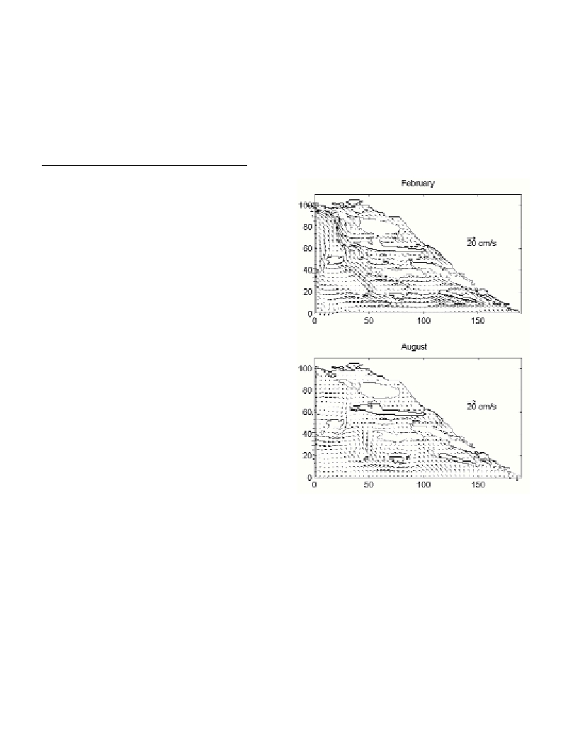
The general flow in the ASHELF-2 domain is directed
northwestward with prominent wakes occurring behind Dalmatian
islands during the greater part of the year (Fig. 1). Current reversal
obtained between islands Hvar and Vis in August agrees with previous
current measurements, which indicate strong seasonal signal in the
surface current field with oppositely directed alongshore ?ow in the
winter and summer seasons (2).
The importance of the properly imposed open boundary conditions
can be seen by comparing current fields modelled for January with
and without nesting procedure. In the numerical experiment without
nesting, surface current field shows numerous cyclonic and
anticyclonic gyres. In the similar numerical experiment with nesting
most of the gyres disappear and the ?ow is dominantly of the
northwest direction.
Modelled temperature annual cycle at the points that correspond to
the coastal and open sea stations shows good agreement with
observations, although modelled annual amplitude is lower than the
one obtained from the data. Surface salinity measured at two coastal
stations shows lower values and higher annual amplitudes than those
obtained in numerical simulations. Discrepancy between modelled
and measured surface salinity in the coastal area can be partly
ascribed to the climatological salinity field used in correcting
procedures, in which coastal areas are not well resolved. Better
agreement between measured and modelled time series is obtained for
the open sea stations although lower annual amplitude is again
obtained by the model.
Acknowledgement.The work reported here has been sponsored
by the Italian Ministry for the Environment (project ADRICOSM,
coordinated by Istituto Nazionale di Geofisica e Vulcanologia) and
by the Croatian Ministry of Science and Technology.
References
1-Zavatarelli M., and Pinardi N., 2003. The Adriatic Sea modeling
system: A nested approach. Ann. Geophys.,21: 345-364.
2-Zore-Armanda M., 1967. On the seasonal variations of the surface
currents in the Adriatic (in Croatian). Hidrogr. God.,66: 69-74.
3-Blumberg A. F., and Mellor G. L., 1987. A description of a three-
dimensional coastal ocean circulation model. Pp 1-16. In: Heaps N. S.
(ed.), Three-dimensional coastal ocean models. AGU, Washington.
Fig. 1. Surface currents in the ASHELF-2 domain in February and August.