Rapp. Comm. int. Mer Médit., 37,2004
135
PRELIMINARY RESULTS OF MEDARGO:
A EUROPEAN PROFILING FLOAT PROGRAM IN THE MEDITERRANEAN
P.-M. Poulain
1*
, J. Font
2
and S. Le Bras
3
1
OGS, Borgo Grotta Gigante 42/c, 34010 Sgonico (Trieste), Italy - * ppoulain@ogs.trieste.it
2
CMIMA-CISC, Passeig Marítim 37-49, 08003 Barcelona, Spain - jfont@icm.csic.es
3
IFREMER, BP 70, 29280 Plouzané, France - Sylvie.Le.Bras@ifremer.fr
Abstract
Four profiling ?oats were deployed in the Catalan Sea and provided temperature and salinity (TS), and subsurface displacement data for
more than a month in fall 2003. The ?oat data revealed high mesoscale variability in the upper sea and a strong shear in the currents
between the surface and intermediate levels.
Key-words: Temperature and salinity, subsurface ?oats, Catalan Sea
Introduction
In the framework of MEDARGO, which is part of the EU-
sponsored MFS project (1), profiling floats will be deployed
throughout the Mediterranean starting in late summer 2004 to provide
TS data in near-real time to forecasting models of the Mediterranean.
In order to assess the functionality of the ?oats and define their
sampling characteristics, four units were operated in the Catalan Sea
in fall 2003. Details about the ?oats’hardware and software, about
their cycling and sampling and about the data telemetry are given
hereafter. The ?oat data in the Catalan Sea are described and
interpreted, with particular focus on the thermohaline structures and
the vertical shear of the currents.
Materials and methods
Two types of profiling ?oats were operated, one called APEX
(manufactured by Webb Research Corporation, USA) and the other
one PROVOR (produced by Martec, France). The APEX is the
successor of the ALACE (2) whereas the PROVOR is based on the
MARVOR technology (3, 4). Two units of each type were acquired.
All ?oats were equipped with Sea-Bird CTD sensors (model 41
pumped MicroCAT). They were programmed in the “Park and
Profile” configuration with a neutral parking depth of 350 m (near the
salinity maximum of the Levantine Intermediate Water - LIW) and a
maximum profiling depth of 700 m, with total cycle periods of 3.5, 4
and 7 days. When at surface, the ?oats are located by, and transmit
data, to the Argos system onboard the NOAA satellites. The data are
processed and archived in near-real time at the CORIOLIS Data
Center (Brest, France; 4) and are disseminated on the GTS following
the standards of the international ARGO program. The two APEX
?oats were deployed in the Catalan Sea on 26 September 2003. A
week later, on 2-3 October 2003, the two PROVOR ?oats were
deployed with the R/V Garcia del Cidin the vicinity of the APEX
?oats. CTD casts (from the ship) were made close to the ?oat profiles.
All ?oats were operated in “Park and Profile” mode until 7 November
2003 providing a total of 35 ascending TS profiles. Thereafter, the
?oats remained at surface until they were recovered.
Results
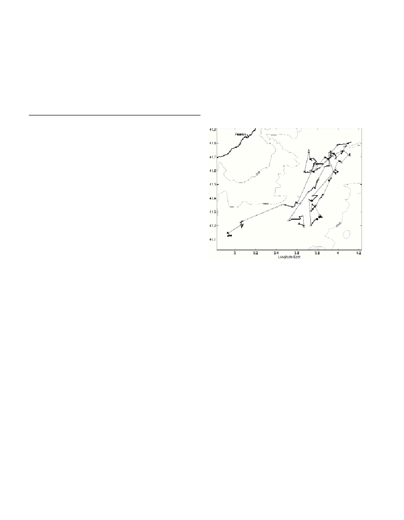
The ?oats were deployed in an area where the prevailing slope
currents are generally southwestward (Northern Current; 5). After
showing some indication of subsurface ?ow towards the northeast
after deployment, all the ?oats were trapped in the Northern Current
and moved to the southwest (Fig. 1). Speeds at the 350 dbar level vary
between 1 and 6 cm/s. Displacements during the time spent at surface
can be of the same order of magnitude as the deep displacements
especially for ?oat 6900226. They show no preferential direction due
to the large variability of the surface currents at meso and inertial
scales. In some cases, the surface and intermediate displacements are
in opposite directions, revealing a significant shear between the two
levels.
The TS profiles obtained by the ?oats are typical for the region,
with a marked salinity maximum in the LIW at about 400 m. The
structure in the upper layer is highly variable and the depth of the
seasonal thermocline varies between 30 and 70 m.
Acknowledgements.We wish to thank the crew of the R/V Garcia
del Cid, A. Juliŕ, M. Emelianov, L. Ursella, R. Barbanti and S. Le
Reste for their skilled and enthusiastic assistance for the ?oat
deployment and recovery operations. This work was supported by the
European Commission (V Framework Program - Energy,
Environment and Sustainable Development) as part of the MFSTEP
project.
Fig. 1. Float trajectories in the Catalan Sea. Thin straight (heavy curvy)
segments denote the subsurface (surface) ?oat displacements. Star and
solid circles represent the deployment and last profile locations, respec-
tively. Open circles represent the locations of the TS profiles. The
200,1000 and 2500 m isobaths are shown.
References
1-Pinardi, N., I. Allen, E. Demirov, P. De Mey, G. Korres, A. Lascaratos,
P.-Y. Le Traon, C. Maillard, G. Manzella and C. Tziavos, 2003. The
Mediterranean ocean forecasting system: first phase of implementation
(1998-2001). Ann. Geophys.,21: 3-20.
2-Davis, R.E. , D.C. Webb, L.A. Regier, and J. Dufour, 1992. The
Autonomous Lagrangian Circulation Explorer (ALACE). J. Atmos.
Ocean. Tech., 9: 264-285.
3-Loaec G., N. Cortes, M. Menzel and J. Moliera, 1998. PROVOR: a
hydrographic profiler based on MARVOR technology. IEEE-Oceans’98,
September 1998, vol. 1: 42-45.
4-Loaec G., Carval T., Le Reste S., Maudire G., 1999. Provor and
Coriolis Data Center: a step towards operational oceanography; Data Buoy
Conference Panel Technical Document N°17: 1-9.
5-Font, J., J. Salat and J.Tintoré, 1988. Permanent features of the
circulation in the Catalan Sea. Ocean. Acta, vol.sp. 9: 51-57.