Rapp. Comm. int. Mer Médit., 37,2004
138
THE IMPACT OF DIFFERENT APPROACHES IN ESTIMATING HORIZONTAL GEO-CHEMICAL FLUXES:
AN EXAMPLE STUDY OF A NORTH ADRIATIC TRANSECT
A. Russo
1
, J. W. Book
2
, H. Perkins
2
, R. Signell
3
, M. Marini
4
, E. Paschini
4
, A. Boldrin
5
, S. Carniel
5 *
, M. Sclavo
5
1
Universitŕ Politecnica delle Marche - Dipartimento di Scienze del Mare, 60131 Ancona, Italy - a.russo@univpm.it
2
Naval Research Laboratory, Stennis Space Center, MS 39529-5004, U.S.A. - book@nrlssc.navy.mil, hperkins@nrlssc.navy.mil
3
NATO SACLANT Undersea Research Centre, 19138 La Spezia, Italy - signell@saclantc.nato.int
4
Consiglio Nazionale delle Ricerche - Istituto di Scienze Marine, 60131 Ancona, Italy - mauro.marini@ismar.cnr.it,
elio.paschini@ismar.cnr.it
Consiglio Nazionale delle Ricerche - Istituto di Scienze Marine, 30100 Venezia, Italy - alfredo.boldrin@ismar.cnr.it,
* sandro.carniel@ve.ismar.cnr.it, mauro.sclavo@ve.ismar.cnr.it
Abstract
During the Adria02 cruise (September-October 2002), physical and bio-geo-chemical data were acquired along the Senigallia-Süsak Island
line, where 7 ADCP and 3 current-meters were deployed. Through numerical model simulations higher resolution water current data are
also available. Estimates were obtained of transported material ?uxes entering and leaving the Northern Adriatic Sea using different
methods, thus contrasting calculations made with geostrophic assumptions, hydrodynamic model simulations, and direct current
measurements.
Keywords: horizontal ?uxes, North Adriatic Sea.
Since the Nilo River damming at Assuan in 1970, the North
Adriatic Sea receives the highest river runoff of the Mediterranean
Sea, most of it coming from the Po River (Fig. 1). The shallowness of
this sub-basin (average depth less than 35 m) makes its physical and
ecological environment highly sensible to variations in river runoff
and atmospheric conditions. River runoff affects the circulation
through buoyancy input, which is one of the major driving forces of
the Western Adriatic Coastal Current (WAC or WACC), and impacts
the ecosystem by introducing large amounts of organic matter,
nutrient salts and sediments. Some studies have attempted to quantify
the exchange rates of water and transported materials between the
northernmost part of the Adriatic Sea and the remainder of the basin.
The first study (1) used chemical data, measured roughly biweekly in
the north Adriatic at one station located in the western area and one
station located in the eastern area, combining them with a water
exchange rate of 10
5
m
3
s
-1
derived by previous geostrophic
calculations. A second study (2), conducted in the same area (roughly
indicated by the dotted line in Fig. 1) but with different methodologies
(more stations but only 4 samplings during 1995/96, with direct
current measurements), quantified the out?ow ?uxes in summer 1995
and winter 1995/96 (only the summer values are reported in Tab. 1 as
this period is more closely related to our study period). The average
nutrient ?ux estimate for summer 2001 reported in Tab. 1 is derived
by monthly estimates made in a third work (3). Physical and chemical
data were collected along the Senigallia-Süsak Island transect
(southeastward of the two previous studies); geostrophic velocities
were computed and combined with measured nutrient salts data to
obtain ?uxes.
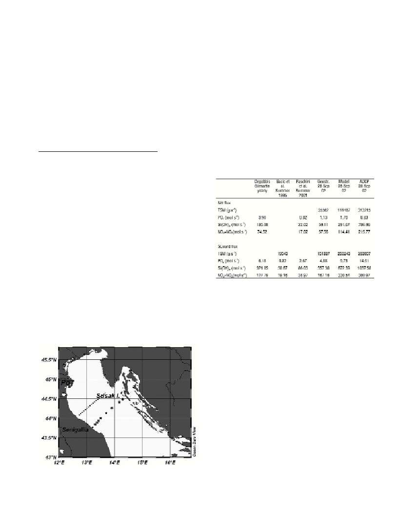
Fig. 1. North Adriatic Sea map with area of previous ?ux estimations
(dotted line) and positions of ADCP (circled dots) and current-meter
moorings (dots) along the Senigallia- Süsak Island transect.
Table 1. Flux estimates according to previous authors (2. reported DIN
instead of NO
3
+NO
2
) and the present work.
From 19 September to 8 October 2002 the international cruise
Adria02 was carried out in the Adriatic Sea onboard the R/V Alliance.
The simultaneous availability along the Senigallia transect of high
resolution CTD casts, bio-geo-chemical sampling stations,
hydrodynamic model simulations, ship-tethered ADCP surveys, and 7
bottom mounted ADCP plus 3 traditional moored current-meters at 2
sites, made possible the computation of ?uxes across the transect
using different methods. On 28 September all the data sets had an
optimal coverage along the transect, so computations were made at
this specific date; geostrophic velocities, daily averaged current data
and model velocities were combined with bio-geo-chemical
parameters to obtain ?uxes (Tab. 1).
Fluxes based on geostrophic velocities are in good agreement with
previous published fluxes, while fluxes computed using direct
measurements and model velocities are in some cases several times
larger. For these computations, the area northeastward of Süsak was
excluded; this fact can significantly affect the net ?uxes, while it can
be considered negligible for the southeastward ?uxes.
References
1-Degobbis D., and Gilmartin M., 1990. Nitrogen, phosphorus, and
biogenic silicon budgets for the northern Adriatic Sea. Oceanologica Acta
13: 31–45.
2-Gacic M., Civitarese G., and Ursella L., 1999. Spatial and seasonal
variability of water and biogeochemical ?uxes in the Adriatic Sea. Pp 335-
357. In: P. Malanotte-Rizzoli and V.N. Eremeev (eds.). The Eastern
Mediterranean as a Laboratory Basin for the Assessment of Contrasting
Ecosystems. Kluwer Academic Publisher, Dordrecht, NL.
3-Paschini E., Russo A., Marini M., Grilli F., Fornasiero P., and Caccamo
G., 2003. In: MAT Project Final Report. (in Italian).
4-Poulain P. M., and Raicich F., 2001. Forcing. Pp 45-65. In: Cushman-
Rosin B. et al., Physical Oceanography of the Adriatic Sea. Kluwer
Academic Publisher. Netherlands.