Rapp. Comm. int. Mer Médit., 37,2004
159
ADRIATIC SEA INTEGRATED COASTAL AREAS AND
RIVER BASIN MANAGEMENT SYSTEM PILOT PROJECT (ADRICOSM)
Nadia Pinardi, Anita Grezio, Paolo Oddo and the ADRICOSM partners (www.ingv.it/adricosm)
INGV, Via Donato Creti 12, Bologna, Italy
Abstract
The ADRICOSM (ADRIatic sea integrated COastal areaS and river basin Management system pilot project) represents an innovative
application of data assimilation to a forecasting system in the coastal areas. A key step toward integrated coastal area management is to
connect the catchment basin runoff and the wastewater management with marine environment monitoring and forecasting since the coastal
areas are strongly forced by the drainage basin inputs and disperse these inputs in a complex hydrodynamic environment.
Keywords: data assimilation, Adriatic Sea, Coastal Management, Ocean Forecasts
Introduction
During ADRICOSM the implementation of an integrated coastal
zone management system in the Adriatic Sea, consisting of a
predictive circulation module and a river basin and wastewater
management module, has taken place. The aims are:
1)the demonstration of the capability to monitor and predict in real
time the shelf and coastal currents variability;
2)the implementation of the monitoring and modelling scheme for
a river basin and its associated wastewater system in a test site;
3)the integration of the river basin modelling with the coastal
current prediction system.
ADRICOSM is possible because several of its components have
been developed in the past ten years, but they have never been put
together or applied to the Adriatic Sea or in a coastal region.
Results
The Mediterranean marine Forecasting System (MFS) experience
has demonstrated that the forecasts is applicable also in critical shelf
area at weekly time scales. In particular the MFS activities have been
developed in a way which takes in account the proper momentum and
tracer ?uxes at the Adriatic Sea open boundaries. The interface
between the MFS model and the Adriatic fields permits the selection
of the lateral boundary (T, S, u, v) during the data assimilation and the
forecasting.
Both large scale and coastal observations are utilized efficiently in
a data assimilation scheme that uses sequential estimations to prepare
initial fields for subsequent forecasts. Sea Surface Temperatures
(SST) from satellite are available daily and are used for the surface
heat ?uxes corrections in the Adriatic model.
Coastal network provides CTD data localized in 4 regions: the
Emilia Romagna Coast, the Golf of Trieste, the Slovenia Coast and
the Croatian Coast. In addition, XBT temperature profiles up to 900
m depths are collected by VOS (Voluntary Observation Ships) along
the Ploce-Malta and the Split-Bari tracks.
Salinity and Temperature coming from CTD stations and
temperature coming from XBT-VOS are assimilated in the Adriatic
Model (Fig. 1), which is POM (Princeton Ocean Model) [1]
implemented by Zavatarelli et al. (2) for the Adriatic Sea. The model
has a horizontal resolution of 5 km and 21 layers in the vertical, high
frequency forcing and daily Po river run off. The assimilation system
is SOFA (System for Ocean Forecasting and Analysis) [3], which is a
multivariate reduced-order optimal interpolation method. This
assimilation system has been successfully applied in the MFS and the
innovative part in ADRICOSM is the sequential assimilation of the
multivariate parameters (T, S profiles from CTD) and univariate
parameters (T profiles from XBT). The sequential assimilation
improves the system and the Adriatic model is efficiently corrected
during the date assimilation using a coordinate transformation from
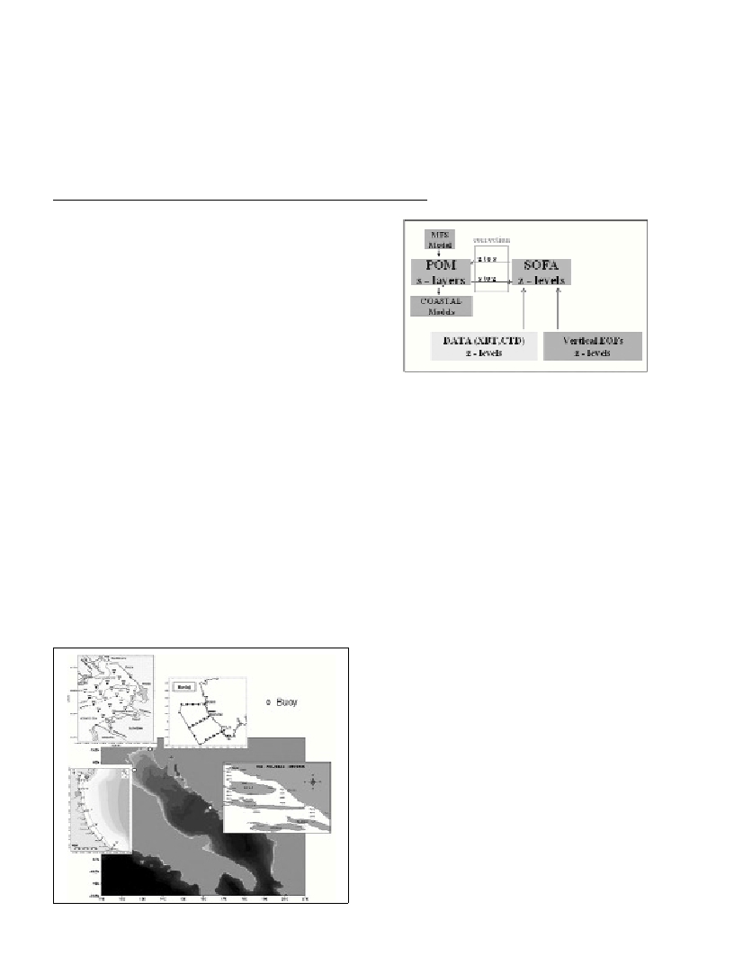
sigma to z and vice versa(Fig.2). Moreover, nested shelf and coastal
models receive the forecasting boundary conditions in “slave mode”.
A simulation systems for the river basin and the coastal currents has
been coupled for the study case of the Cetina river in the Croatian
coastal area.
Conclusions
ADRICOSM started to forecast in real time in May 2003 and it is
continuing. Forecasts are done once a week and for seven days in the
future. Assimilation of coastal CTD and open ocean XBT data is
carried out by an Optimal Interpolation scheme, adapted to the coastal
areas. Data assimilation improve the representation of the ocean
processes by optimally combining a dynamic model and in situ data
and provides better initial conditions for weekly coastal ocean
forecasting.
References
1-Blumberg A.F., Mellor G.L., 1987. A description of a three
dimensional coastal ocean circulation model. Pp. 1-16.In : N.S. Heaps
(ed.), Three dimensional ocean models, Coastal Estuarine Sci., AGU
Washington D.C.
2-Zavatarelli M., N. Pinardi, V.H. Kourafalou and A.Maggiore, 2002.
Diagnostic and Prognostic model studies of the Adriatic Sea General
Circulation: Seasonal variability. J. Geophys. Res.,107: 3004-3025.
3-De Mey P., Benkiran M.,2002. A multivariate Reduced-order Optimal
Interpolation Method and its application to the Mediterranean Basin-
scale Circulation. Pp. 281-305. In : N. Pinardi, J.Woods (eds.), Ocean
Forecasting.