Rapp. Comm. int. Mer Médit., 37,2004
161
CORIOLIS, A FRENCH PROJECT FOR IN SITU OPERATIONAL OCEANOGRAPHY.
S. Pouliquen
1
, T. Carval1, Y. Desaubies
1
, L. Petit de la Villéon
1
, G. Loaec
1
, L. Gourmelen
2
(1)
IFREMER, BP70, F29280 Plouzané - Sylvie.Pouliquen@ifremer.fr
(2)
EPSHOM, BP426, F29275 Brest Cedex
Abstract
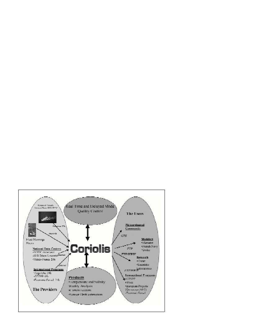
The seven French agencies concerned by ocean research are developing together a strong capability in operational oceanography based on
a triad including satellite altimetry (JASON), numerical modelling with assimilation (MERCATOR), and in situ data (CORIOLIS).The
CORIOLIS project aims to build a pre-operational structure to collect, valid and distribute ocean data (temperature/salinity profiles and
current speeds) to the scientific community and modellers.
The seven French agencies concerned by ocean research are
developing together a strong capability in operational oceanography
based on a triad including satellite altimetry (JASON), numerical
modelling with assimilation (MERCATOR), and in situ data
(CORIOLIS).The CORIOLIS project aims to build a pre-operational
structure to collect, valid and distribute ocean data
(temperature/salinity profiles and current speeds) to the scientific
community and modellers. CORIOLIS aims at four goals :
(1)To build up a data management centre, part of the ARGO
network for the GODAE experiment, able to provide quality-
controlled data in real time and delay modes.
(2) To contribute to ARGO ?oats deployment mainly in the Atlantic
with about 250 ?oats during the 2001-2004 period.
(3) To develop and improve profiling ARGO ?oats. PROVOR is a
self-ballasted ?oat, able to drift at a user-defined parking depth and
then to dive to 2000m before profiling up to the surface where data are
transmitted using the Argos system. More than 100 cycles can be
performed during its 3-year lifetime.
(4) To integrate into CORIOLIS all other data presently collected at
sea by French agencies from surface drifting buoys, PIRATA
anchored buoys, oceanographic research vessels (XBT,
thermosalinograph and ADCP transmitted on a daily basis).
CORIOLIS has three phases:
– Preparation phase (2000-2002) synchronised with MERCATOR
demonstration phase, which sets up the system,
– Demonstration phase (2003-2005) during which CORIOLIS will
operate in an operational mode,
– Lastly, an Evaluation Phase (2004-2005), which will provide
recommendations starting from this experience, on what, should be a
sustainable operational structure, in accordance with international
plans that will follow the ARGO/GODAE expe
CORIOLIS data centre, already one of the two global data centres
for ARGO, is the data centre for 5Prcd projects like Gyroscope and
MFSTEP and is an important partner in projects within GMES et 6
th
PRCD calls like Mersea.
The CORIOLIS project implementation by the French agencies in
charge of oceanography, will contribute to the ocean observing
system, providing world coverage of the oceans in real time.
CORIOLIS a multi-disciplinary pilot project is involved in new
autonomous instruments development with up-to-date transmission
capability, in ?oat deployment in the Atlantic Ocean then world and
in data collection, processing and distribution to users (public
authorities, scientific community, industry sector,). It aims to be
sustained when the world programs, to which it refer to, will have
drawn their assessment for the coming years. One will then witness an
evolution similar to the one observed in meteorology field twenty
years ago: the deep-sea oceanography will go from science to
operational for the benefit of the world population on a sustainable
base. Nevertheless it will then be necessary to assume the recurring
cost of such a program