ACOUSTIC SEABED CLASSIFICATION AND
MAPPING OF SEAGRASSPOSIDONIAOCEANICA(L.) DEL. MEADOW
Vesna Macic
1*
, Claudio Badin
2
, Zoran Kljajic
1
, Sreten Mandic
1
1
Institute of marine biology, Kotor, Serbia and Montenegro, * marikultura@cg.yu
2
F.A.R.O., Pordenone, Italy
Abstract
The purpose of our work was to using echo-sounders and acoustic seabed classification identify and map Posidoniameadows on the south-
west part of St. Nicola island (Montenegrian coast). We used the QTC VIEW system to capture the full waveform acoustic data and than
using software QTC IMPACT we identified the best features combinations to distinguish groups of echoes representing different seabed
(Posidoniameadow, send, rock etc.). For each recorded echo we tagged coordinates from GPS so we have necessary information�s for
positioning of classified seabed.
Keywords: Posidonia, echo-sounders, mapping, Adriatic sea
Rapp. Comm. int. Mer M�dit., 37,2004
393
Introduction
The seagrass Posidonia oceanica(L.) Del. is considered to play the
most important role in the coastal Mediterranean region. Unfortunatly
because of many natural and human-induced events world-wide
decline in seagrasses has been reported. The purpose of our work was
to identifay and map P. oceanicameadows using digital seabed clas-
sification on the sout-west part of St. Nicola island (Montenegrian
coast) in order to with periodic mapping and monitoring, protect and
preserve these important marine resources.
Material and methods
It is well known that the seabed echoes contain much more infor-
mation than necessary for simply determining depth. The signal, an
acoustic re?ection which includes backscatter, bottom reverberation
and spectral returns has a direct relationship with and is a function of
the character of the seabed. So acoustic seabed classification is the
organization of the sea ?oor and direct subsurface into seabed types or
classes, based on characteristics of an acoustic response (1). For this
purpose we used the QTC VIEW system and than using software QTC
IMPACT we indetified groups of echoes representing different seabed
types (P. oceanicameadow, send, rock, etc.).
The QTC VIEW instrument interfaces directly to conventional echo
sounders. The system is connected, in parallel, between the sounder
and monitors the transmitted pulse and the seabed acoustic returns in
a manner which not interfere with the normal operation of the echo
sonder (2). The QTC View than digitizes and pre-processes the echo
after which the resultant data are analyzed by multiple algorithms. A
3-D clustering process generates discrete classes representing the
acoustic diversity of the data (3). Similar echoes are grouped into
classes and user relates the acoustic class to the physical characteris-
tics of the seabed through the calibration process that is diving in this
case. For each recorded echo we tagged coordinates from GPS so we
have necessary informations for positioning of classified seabed.
After survey and processing with software on display we have clus-
ters containing similar acoustic signatures in Q-space, than a track
plot showing locations of the six classes that we determined, a
bathymetry plot showing how the classes are distribuited by depth and
statistical confidence of the class assignments.
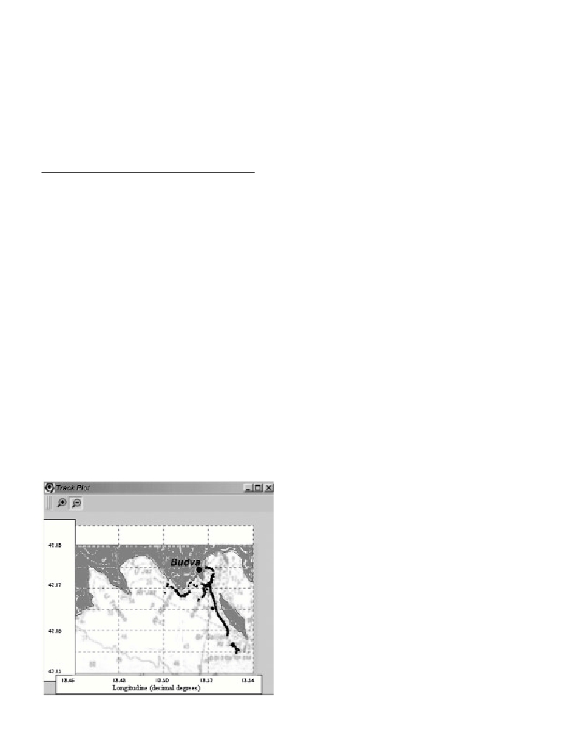
Conclusion
In purpose of mapping P. oceanicameadows, with QTC acoustic
system we located P. oceanica meadows so that divers easely can find
positions of interest for furder investigation (Fig. 1). These are first
maps of seagrass meadows in this area so they will be of grate inpor-
tance for further monitoring.
When compared with traditional seabed geological mapping tech-
niques, acoustic seabed classification QTC is capable of providing
accurate, repeatable and nondestructive seabed classification informa-
tion. Although aerial photographs represent one of the most efficient
methods in terms of its cost, rapidity and reliability, the image pro-
cessing technique have been used only for the surface layer (from 0 to
20m) (4.), so quality of QTC classification technique is that we can
use it in the whole area of the Posidonia meadows.
References
1-Collins, B. and Rhynas, K., 1998. Acoustic seabed classification using
echo sounders: Operational considerations and strategies. Proceedings of
the Canadian Hydrographyc Conference. Pp. 384-390. Victoria BC,
Canada.
2-Quester Tangent Corporation. 2002. QTC IMPACT User Manual,
DMN-MIMP-0001-R03B(2002). Quester Tangent Corporation, Sidney,
B.C. Canada.
3-Collins, W.T., Gregory, R.S., and Anderson, J.T., 1996. A digital
approach to seabed classification. Sea Technology, Vol.37., No. 8: 83-87.
4-Pasqualini, V., Pergent-Martini, C., and Pergent, G. 1999. Environmen-
tal impact identification along Corsican coast (Mediterranean sea) using
image processing. Aquatic Botany, 65: 311-320.
Fig. 1. Track Plot showing only positions of Posidoniameadows.