MAPPING DISTRIBUTION OF BIODIVERSITY IN MARINE RESERVES
Paolo D’Ambrosio, Giuseppe Guarnieri, Simonetta Fraschetti
*
, Antonio Terlizzi, Simona Bussotti
Dipartimento di Scienze e Tecnologie Ambientali, Universitŕ di Lecce, CoNISMa, Lecce, Italy – giuseppe.guarnieri@unile.it
Abstract
An adequate knowledge of habitat and assemblage distribution has important consequences in conservation and management of Marine
Protected Areas. A fine-scale study of two MPAs located in Apulia is here reported to analyse existing protection schemes and to assess if
habitats and communities are properly represented in the differently protected zones and if the no-take and no-access zones are
representative of the general reserve. Results emphasize that, at present, zoning is totally arbitrary in both MPAs with the consequences
that detailed information on the distribution of the biota could greatly increase current zonation patterns.
Keywords: Marine Protected Areas, zoning plan, biodiversity, GIS
Rapp. Comm. int. Mer Médit., 37,2004
509
Introduction and Methods
A number of papers have already discussed the general lack of
baseline information on biodiversity distribution in coastal marine
habitats and especially within Marine Protected Areas (1, 2). This
general lack of knowledge has important consequences since it
prevents either an adequate zoning schemes and the potential iden-
tification of networks of habitatand communities representative at
regional scale (3). A better knowledge in this field might also avoid
possible sources of habitat confounding when experimental designs
needing the selection of appropriate controls are used to demonstrate
effectiveness of protection.
The aim of the paper is to map the distribution of habitat and
communities in order to assess if they are properly represented in the
differently protected zones and if the no-take and no-access zones are
representative of the general reserve.
Data are reported from a series of extensive field surveys carried out
in last the three years in the MPAs of Torre Guaceto and Porto Cesareo
(Apulia, Italy). Both MPAs are divided in three zones (namely: A, B,
C) varying with respect to the degree of restriction of human activities.
Here direct observation methods, such as beach transects and SCUBA
diving surveys (using global position system GPS)were adopted. Data
were then imported in a GIS to create thematic maps.
Results
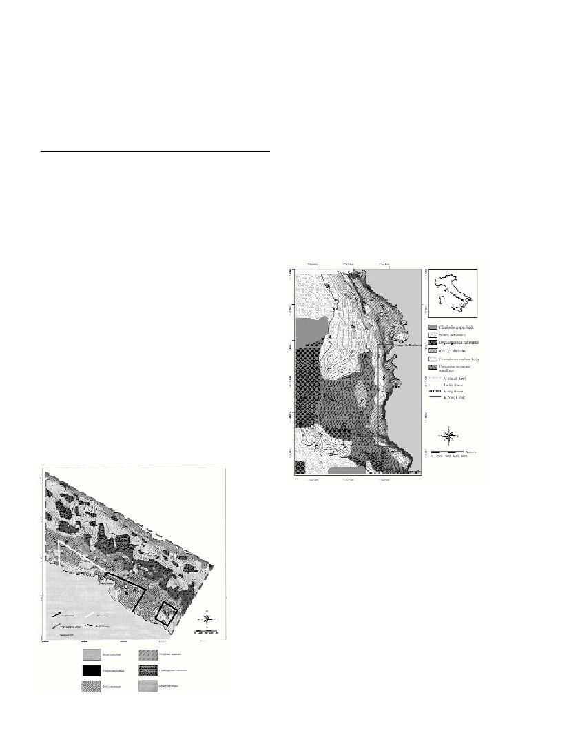
The MPA of Torre Guaceto (40°42’N; 17°48’E) has a surface of
about 2.207 ha and is embedded within a human-dominated
landscape. This MPA exhibits complex spatial patterns being
characterized by a set of very different habitats (from bioconstructors
to seagrasses). However, the proportion of habitat types targeted for
full protection is not adequately represented. The lack of an adequate
knowledge before the institution prevented appropriate decisions
about reserve boundaries, with the consequences that preco-
ralligenous and coralligenuos formations and Posidoniaoceanica
meadows are not included in the no-take no access zone (Fig. 1).
The MPA of Porto Cesareo (40°14’N; 17°54’E) has an extension of
16.654 ha. It is a small village with intense turistic activities. Results
show that also in this case sea grasses and coralligenous formations are
excluded from the no-take no access zone. Several other self-contra-
dictions emerge. The date mussel Lithophaga lithophagafishery, albeit
prohibited, is very active inside the MPA, with the result that the extent
of desertified seascape is continuously increasing and one of the most
represented community is that of sea urchin barrens. Moreover, a sew-
age outfall and a fish and mussels aquaculture farm are located within
the MPA in proximity of the integral protection zones and a sandy
beach with free access is within the no-take no access zone (Fig. 2).
Discussion and Conclusion
In both cases, results emphasize that present zoning is totally
arbitrary and collected data provide different scenarios for a correct zo-
ning plan able to include both ecological and socio-economic aspects.
Thus, large-scale mapping even if are costly and time-consuming,
allow managers to visualise the spatial distribution of habitats, thus ai-
ding the planning of networks of marine protected areas and allowing
the degree of habitat fragmentation (in the case of Porto Cesareo deter-
mined by the date mussel fishery) to be monitored. As Gray states (4),
a mosaic of marine habitats must be protected if complete protection of
biodiversity is to be achieved. Representative samples of species and
assemblages distinctive of a particular locality or region should be
included within reserve boundaries to grant their long-term persistence.
References
1-Cabeza, M., Moilanen, A., 2001. Design of reserve networks and the
persistence of biodiversity. Trends in Ecology and Evolution, 16, 242-248.
2-Villa F., Tunesi L., Agardy T., 2002. Zoning Marine Protected Areas
through Spatial Multiple-Criteria Analysis: the Case of the Asinara Island
National Marine Reserve of Italy. Conservation biology16 (2), 515-526.
3-Sala E., Oropeza O., Paredas G., Parra I., Barrera J.C., Dayton P.K.,
2002. A general model for designing networks of marine reserve. Science,
298: 1991-1993.
4-Gray, J.S., 1997. Marine Biodiversity: Patterns, threats and
conservation needs. Biodiversity and Conservation6, 153-175.
Fig. 1.
Map of the Marine
Protected Area of
Torre Guaceto.
Fig. 2.
Map of the
Marine Protected
Area of Porto Cesareo.