Swath bathymetry
S
EABEAM
2120 is a new swath system that has been specifically
designed to accommodate users with survey requirements exceeding
6000m water depth accomplishing a satisfactory resolution without mount-
ing a very large array.The first installation of this type with 1.80 beam
width, has been completed during 2000 on the Hellenic vessel R/V Aegaio.
It has an angular coverage sector of 150 degrees with 149 beams, covering
a swath width from 7.5 to 1.15 times the water depth for depths 1000m to
5000m respectively, with a maximum swath coverage of about 9 Km, oper-
ating with vessel’s speed up to 11 Knots. The above system was used dur-
ing November 2000 with an average ship’s speed of 6 Knots in order to
achieve better along track resolution. A total track length of 495 Km have
been surveyed resulting to a coverage of about 1084 Km
2
, between the
small islets Falkonera and Antimilos. The processed detailed bathymetric
map is presented on Figure 1, as gray-tone coded bathymetry with a con-
tour interval of 10m, in reduction from the colored original map of 1:25000
scale. The maximum depth 1180m coincides with the deep basin at the
western edge of the map to the north of Falkonera islet, while the shallow-
est depth 83m stands on the top of the southern side of this basin east of
Falkonera. The maximum slopes (30-50% ) are observed to the south,
close to Falkonera and delineate the southern border of the basin. The sea-
bottom relief presents a high heterogeneity at various scales of topograph-
ical variations which permit the distinction of discrete physiographic units
that may represent different geological basement.
Interpretation of geological structures
The surveyed area, as can be seen in the inset map of Figure 1, is locat-
ed in Myrtoon sea, at the junction between the Myrtoon basin, Cretan
basin, volcanic arc and the south-western border of the Cycladic plateau.
The overall neotectonic structure of the studied area is defined by three
prominent features: a deep basin at the west, a canyon type feature at the
north-east and an area of rough relief at the south-east north of Antimilos.
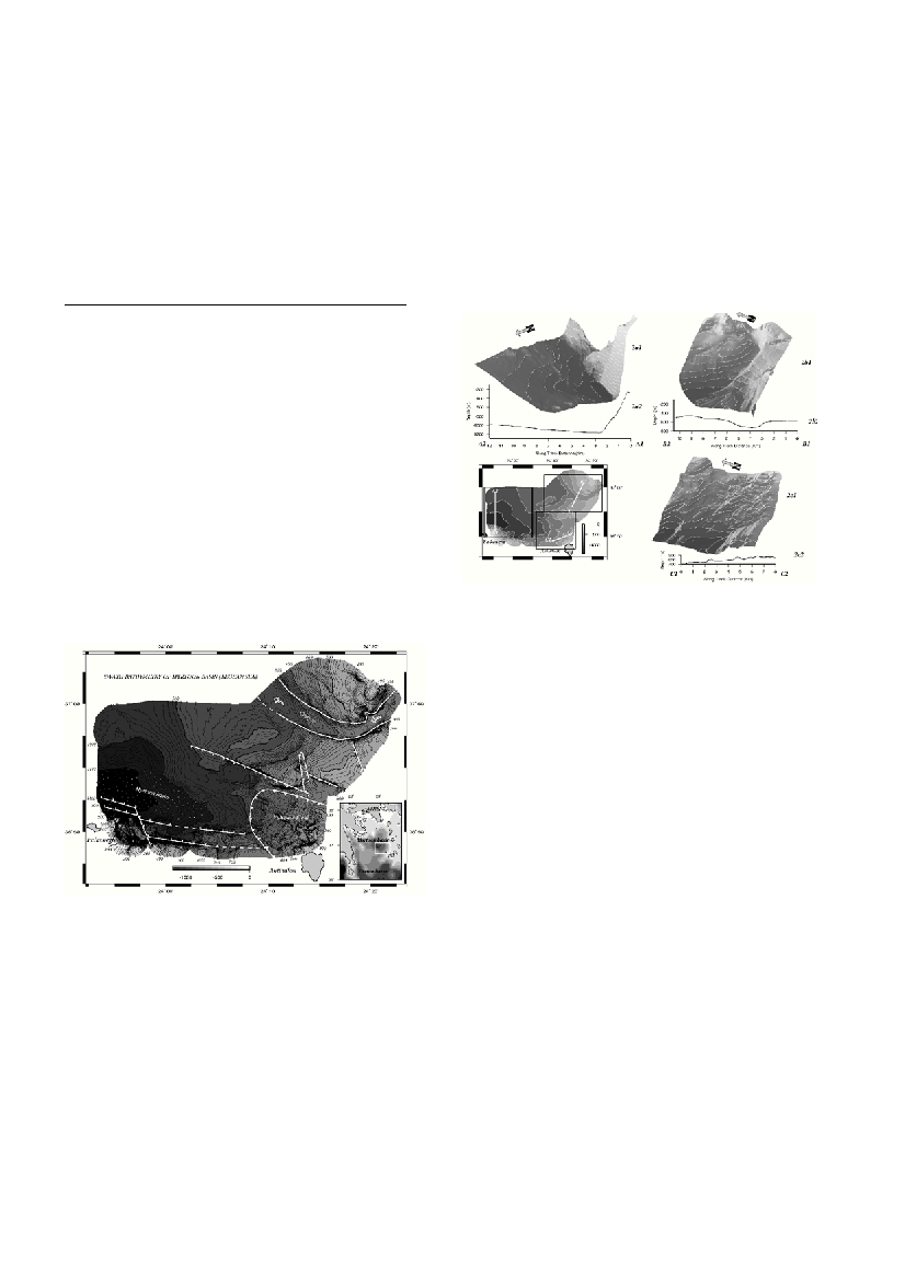
The basin is developed in an approximately WNW-ESE direction as an
elongated asymmetric tectonic graben with a length more than 8.5 Km and
a width less that 3.5 Km (Fig. 2a1). It exhibits very steep slopes to the
north of Falkonera and abruptly passes to a planar morphology slightly
plunging to the south with slopes of 1-2% (Fig. 2a2). The submarine
canyon is a semicircular channel that ?ows from the NE through the south-
ern margin of the Cycladic plateau and discharges at almost right angle
(Fig. 2b2). It is 200-300m deep, with a length of approximately 20 Km
and a width from 1Km to 3Km (Fig. 2b2). The morphology of this canyon
is most lightly inherited from older geological period when the Cycladic
plateau was emerged and the present-day Cycladic islands were the sum-
mits of the mountain ranges. The peculiar rough relief exposed NW of
Antimilos is presented by small undulations circular and oblong with a
diameter of about 200-400m and highs of the order of 50m (Fig. 2c1, 2c2).
This special relief has a distinctive signature also on the amplitude of the
backscattered signal. The above signature may re?ect a volcanic field in
the northern prolongation of Antimilos volcano. The special morphologi-
cal features may represent submarine volcanic debris, ?ows, submarine
domes, necks and dikes. It is worth noted that, based on the dip of the vol-
canic formations on the northern part of Antimilos, Marinos (1) has sug-
gested the existence of another volcanic center north of Antimilos.
The morphostructural regime revealed by the detailed analysis of the
b
a
t
hymetry pointed out the existence of two major fault zones of W
N
W-
ESE direction, which form an asymmetric tectonic graben. The planar part
of Myrtoon basin, previously described, occupies the central part of this tec-
tonic graben and is developed, mainly, along the southern marginal fa
u
l
t
zone which exhibits a vertical fault throw of more than 1 Km, in contrast
to the fault throw of the northern margin which is only a few hundred
meters. This general tectonic trend follows the regional trend of the A
eg
e
a
n
volcanic arc and indicates a horizontal extension in NNE-SSW direction
(2). The Fa
l
konera-Antimilos ridge developed to the south of the southern
m
a
rginal fault constitutes a W
N
W-ESE tectonic horst that separates the tec-
tonic graben of Myrtoon basin from the major structure of the Cretan back-
arc basin. A secondary fault system of NNW-SSE direction intersects the
p
r
evious major fault structure creating smaller neotectonic blocks, as the
blocks between the canyon and the volcanic fie
l
d
.
References
1- Marinos, G., 1961: The Antimilos Volcano in the Aegean Sea. Bull.
Geol. Soc. Greece, IV/1: 38-50.
2- Papanikolaou, D., 1993: Geotectonic evolution of the Aegean. Bull.
Geol. Soc. Greece, 28/1: 33-48.
Rapp. Comm. int. Mer Médit., 36,2001
3
GEOLOGICAL STRUCTURE OF THE MYRTOON BASIN (AEGEAN SEA) BASED ON SWATH BATHYMETRY
Alexandri M.
1
*, Papanikolaou D.
2
, Nomikou P.
1
, Ballas D.
1
1
National Centre for Marine Research, Athens, Greece
2
Dept. of Geology , University of Athens, Greece
Abstract
A novel structure of the sea-bed has been revealed in the junction point among the Myrtoon basin, Cretan basin, volcanic arc and the south-
western border of the Cycladic plateau. The bathymetric map, resulted by recently acquired multibeam data permitted the distinction of:
a) a deep basin at the west which represents an asymmetric tectonic graben with very steep slopes and with a maximum subsidence of
–1080m; b) a canyon type feature at the north-east which runs through the western Cycladic plateau producing an arcuate depression of
about 300m deep, for a length of approximately 20 Km; c) a rough area with an irregular small scale relief at the south-east which is inter-
preted as the submarine prolongation of the Antimilos volcano. The tectonic regime is outlined by two major fault zones: one of WNW-
ESE, direction which constitutes the southern marginal fault of the Myrtoon basin separating it from the Cretan basin by the Falkonera-
Antimilos tectonic horst and the second of WNW-ESE direction which represents the northern margin of the Myrtoon basin but with much
less subsidence. A secondary fault set of NNW-SSE direction subdivides the regional structure in smaller neotectonic blocks.
Keywords: Swath mapping, tectonics, Aegean Sea, Cretan Sea
Figure 1.Bathymetric map
Figure 2.Perspectives images and bathymetric profiles of
Myrtoon basin (a), Canyon (b), volcanic field. (c)