Introduction
The Alboran Sea is a narrow (~200 km wide and 350 km long) basin
located in the westernmost Mediterranean Sea. It is connected to the
Atlantic Ocean through the Straits of Gibraltar and is characterized by
narrow shelves, an irregular slope and several sub-basins, ridges and
seamounts. The Alboran Ridge is a linear NE-SW and strong bathy-
metric high that extends 180 km and rises locally in the Alboran
island. The Alboran Sea is a key location to understanding the in?u-
ence on the Mediterranean paleoceanography of the Atlantic-Medi-
terranean gateways. The Atlantic surficial waters pass through the
Straits of Gibraltar, shows a wide anticyclonic gyre in the western
Alboran basin and takes a WNW-ESE direction on the Alboran Ridge
before moving eastwards (1). The Quaternary evolution has been con-
trolled mainly by the interplay of tectonics, sea level, climate changes,
and ocean circulation (2, 3). The goal of this paper is to study the rela-
tion between sediment distribution and ocean circulation as well as the
in?uence of the Alboran ridge.
Material and methods
Bathymetric (echosounder Furuno FUG 11), high resolution seis-
mic re?ection (ORE 3.5 kHz) and side scan sonar (EG&G, 500 kHz)
data and dredges ranging from 0 to 500 m depth were used to study de
northeastern segment of the Alboran ridge along two oceanographic
cruises (Coral 8209 and Alboran 9409). A microphysiographic study
has been performed based on a side scan sonar mosaic (4).
Bathymetric characteristics
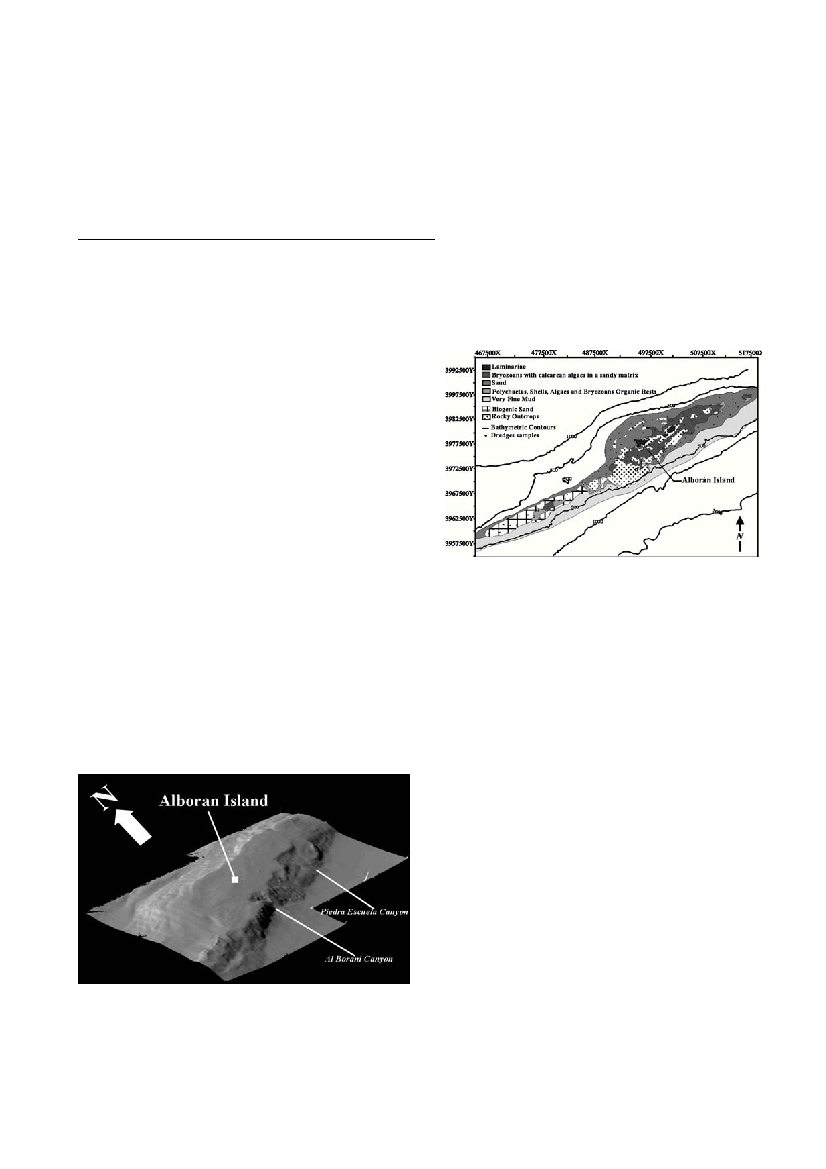
The ridge in this area can be divided in three sectors (Fig 1). The
northeastern one shows two mains relieves at 50 meters depth and the
shelf gently deep to 130 meters. In the Central Sector, the shelf is con-
stituted by some irregular relieves which the main is the Alboran
Island. From 0 to 50 m depth, the bathymetric contours, rhomboedric
and concentric, rounds the island. Between 50 and 100 m depth, the
bathymetric lines are elliptic with a NW-SE major axis. The southern
face is abrupt with a high slope from 100 meters depth, meanwhile, a
?at zone, without relief, emphasizes the northern face between 110
and 120 meters depth. The southwestern sector is a very narrow shelf
with two highs at 85 and 80 m depth respectively.Two submarine
canyons (Piedra Escuela and Al Borani) have been differentiated in the
southern slope, the second one is related to a well-developed subma-
rine fan (5).
Sediment distribution
The sedimentary pattern on the Alboran ridge shows two main char-
acteristics: 1) the textural distribution is sandy in the northern area and
muddy in the southern area of the ridge, both areas are separated by a
central elevation with several volcanic outcrops, and 2) the carbonate
character of sediments especially in the central area (Fig. 2).
There are a clear transition southwards from sands to carbonate sed-
iments and to fine muds. Although it can be appreciated small rock
outcrops in the northeastern sector and several volcanic outcrops
around the Alboran island in the central sector of the studied area.
Carbonates are constituted by bryozoans and calcarean algaes mixed
with sands located in an elliptic area SW-NE directed and placed 100
m depth, however in the southwestern sector they are biogenic sands
(polychaetas, algaes and bryozoans rests) and rodoliths containing the
same organic rests. The origin of this sedimentary pattern have to be
related with the interaction between the Alboran ridge as a barrier
against the Atlantic surficial water masses controlling its ?ow.The
southern ?ank remains leeward of this hydrodinamic regime and
should develop an “island effect” that should favour a highly produc-
tive pelagic and benthic ecosystem, as well as a cascade contribution
of biogenic and mud sediments on the southern area.
References
1. Béthoux, J.P. and Prieur, L., 1984. Hydrologie et circulation in
Mediterranéean nord-occidentale. In: Bizonet al. (eds.), Ecologie des
Microorganismes en Méditerranée Occidentale: ECOMED. Assoc. Franc.
Tech. Petrole., pp. 13-22.
2. Comas, M.C., Platt, J.P., Soto, J.I. and Watts, A.B. 1999. The origin and
tectonic history of the Alboran Basin: Insights from Leg 161 Results. Zahn,
R., Comas, M.C., and Klaus, A. (eds.), Proceedings ODP, Scientific Results,
161: 555-579.
3. Hernández-Molina, F.J., Somoza, L., Vázquez, J.T., Lobo, F.J., Fernández-
Puga, Mª.C., Llave, E. and Díaz del Río, V., 2001. Quaternary stratigraphic
stacking patterns on the continental shelves of the southern Iberian Peninsula:
Their relationship with global climate and palaeoceanographic changes.
Quaternary International, (in press)
4.Vázquez, J.T., Bárcenas Gascón, P., Díaz del Río, V. and Sanz, J.L., 2000.
Características Morfoestructurales del Entorno Sumergido de la Isla de
Alborán.Geotemas, 1 (4): 235-238.
5. Bárcenas, P., Vázquez, J.T., Díaz del Río, V., Fernández-Salas, L.M., Tello,
O. and Sanz, J.L., 2000. La Vertiente Meridional del Banco de la Isla de
Alborán: presencia de dos Sistemas Cañón - Abanico Submarino. VI Reunión
Nac. Geomorfología, Abstracts, p. 169.
Rapp. Comm. int. Mer Médit., 36,2001
4
SEDIMENT PATTERN DISTRIBUTION AND MORPHOLOGY OF THE ALBORAN RIDGE AND
ITS RELATION WITH THE ANTICYCLONIC GYRE
Bárcenas P.
1
, Díaz del Río V.
2
, Fernández-Salas L.M.
2
* and Vázquez J.T.
1
1
Dpto. de Geología. Facultad de Ciencias del Mar. Universidad de Cádiz, Spain - diazdelrio@ma.ieo.es
2
Instituto Español de Oceanografía., Fuengirola, Spain.
Abstract
The Alboran ridge is a linear seamount that divides the Alboran basin in two sectors and interferes in the general circulation pattern. The north-
eastern segment of this ridge has been studied by means of high resolution seismic, side scan sonar data and dredges. The sediment pattern shows
a transition southwards from sands to biogenic sands or biogenic carbonates and muds. This particular distribution has been related to the inter-
action between the Atlantic in?ow and the ridge generating a high pelagic and benthic productivity as well as mud sediments domination south-
wards the ridge.
Keywords:Western Mediterranean, Alboran Ridge, sediment transport.
Figure 1. Digital terrain model of the Alboran ridge northeastern seg-
Fig. 2. Surficial sedimentary pattern on the Alboran ridge northeastern

