Rapp. Comm. int. Mer Médit., 36,2001
22
Introduction
The Black Sea, one of the largest inland seas in the world lying at the
junction between Europe and Asia, is both oceanographically and geo-
logically unique because of its to anoxic layer below 100-150 m.
Although there is ex
c
e
s
s
ive supply of terrigenous sediment input in the
Black Sea, pelagic sedimentation plays the major role in the deep (1).
Since 1991 the group formed around the UNESCO/TREDMAR
Training-Through-Research (TTR) program has inve
s
t
i
gated the
Black Sea with the works of other groups. During these surveys, SIM-
RAD EM 12S low frequency multibeam and SEABAT echosounders
were used to obtain bathymetric charts and re?ectivity maps of the sea
?oor. In addition, MAK-1 deep-tow side scan sonar and subbottom
profiler system was used to get acoustic images of the sea?oor and the
shallow sediments. SIMRAD EM 12S multibeam echosounder oper-
ates at 13 kHz frequency and has an angular coverage of 1200 m. The
MAK-1 combined side scan sonar and subbottom profiler system has
a swath range of up to 500 m per side in long-range mode (30 kHz)
and up to 200 m per side in high-resolution mode (100 kHz). The high-
resolution subbottom profiler sections and the side scan sonar records
shown in this study were compiled from several TTR researches.
Turkish continental slope
Turkish Continental Slope of the Eastern Black Sea Basin, which
has a relatively smooth slope and deepens from 305 m to 1945 m.
depth, comprises of rectilinear gullies and V-like channels (2). In con-
trast with the concave Russian continental slope, the Turkish conti-
nental slope has a convex morphology.The slope gradient becomes
progressively steeper as it is traced downwards from the top, which is
the result of either mass movement or structural control. Maximum
slope angle detected is 12.6° (3). The slope is cut by only a small num-
ber of canyons and valleys, which are generally on a smaller scale than
those found on the Russian Continental Slope. The lower section of
the slope comprises relict slump structures overlain by a semi-contin-
uous surficial unit of parallel-bedded sediments. The middle section of
the slope exhibits a steeper gradient, and slump structures are observed
at the seabed here. The upper slope shows a zone of syn-sedimentary
thrust faults (the upslope side is down- thrown). The basin and the
canyons are a continuation of the Yesilir-mak River across the shelf to
the continental slope. The basin and the canyons deepen towards the
northwest.
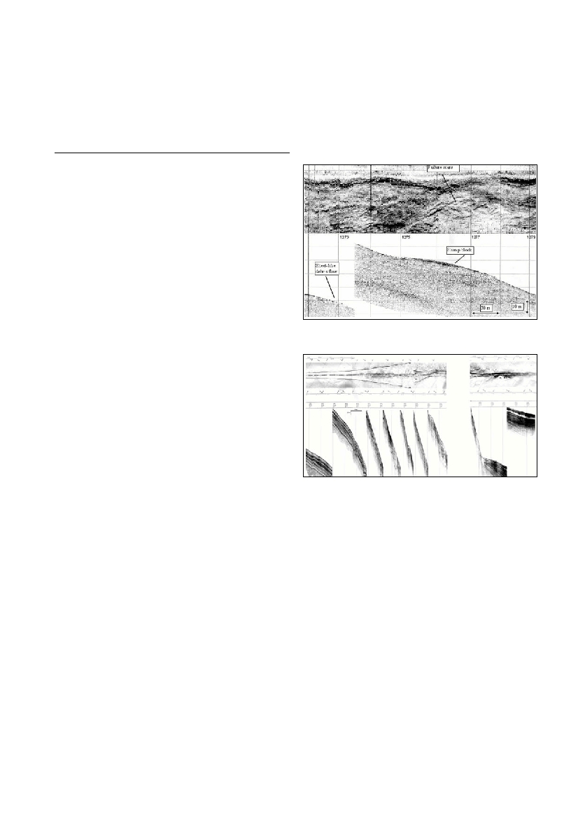
The sediments on the continental slope show slump and creep struc-
tures (Fig. 1). The seabed slumping and creep occurs mainly in areas
with slope gradients over 2°. During slumping, a mass of superficial
sediment becomes detached from a seabed slope along a slip plane and
moves downslope. Creep is the imperceptible but continuous move-
ment of sediment down a slope in response to gravity. It is a viscous
type of ?ow in which there is internal and permanent deformation. The
steep slope exhibits minor and major northward dipping listric faults
as a result of slump and creep features. The depth of the shallow gas
remains constant at 20 meters (4, 5).
This has been clearly identified by the slide faults on the sonar and
especially the landslides on the subbottom profiler records. The chan-
nels can be identified clearly on the sonar mosaics, bathymetric charts
and subbottom profiler records, the channels are the best visible on the
cross-lines of subbottom profiles (Fig.2). The velocity and direction of
the sliding and ?owing down of the material is not constant along the
slope, but also in time duration. The sediment transportation direction
is controlled by the general direction of the slope and channel direc-
tion. These rivers have marked associated submarine canyon systems.
Turbidity current activity is responsible for much of the movement of
sediment into the canyons. Slumping or turbidity ?ows of sediment
from steep side walls of canyons is also thought to be a possible cause
of damming the main channel and delaying sediment transport.
References
1- Sengor A.M.C. and YilmazY., 1981. Tethyan Evolution of Turkey:A
PlateTectonic Approach, Tectonophysics, 75: 181-241.
2- Cifci G., Dondurur D. and Ergün M., 2000. Sonar and High
Resolution Seismic Studies in the Eastern Black Sea Basin, paper pre-
sented at the meeting of International Earth Sciences Colluquium on the
Aegean Region (IESCA-2000).
3-Woodside J.M., Ivanov M.K. and LimonovA.F., 1997. Neotectonics
and Fluid FlowThrough Sea Floor Sediments in the Eastern
Mediterranean and Black Seas. UNESCO reports in marine science,
Paris, No. 48.
4- Cifci G., KruglyakovV., Ergun M. and Pomomoryov I., 1998.
Acoustic Anomalies in Gas Saturated-Shallow Sediments in the Eastern
Black Sea, Proceedings of the 12th International Petroleum Congress and
Exhibition of Turkey, pp.400-411.
5- Ergun M. and Cifci G. 1999. Gas Saturated Shallow sediments in the
Eastern Black Sea and Geohazard effects, Proceedings of Offshore
Technology Conference, pp.621-630. Texas: USA.
HIGH RESOLUTION SEISMIC AND SONAR CHARACTERISTICS
OF THE EASTERN BLACK SEA TURKISH CONTINENTAL SLOPE
M. Ergun*, G. Cifci and D. Dondurur
Dokuz Eylul University, Engineering Faculty, Department of Geophysics, Tinaztepe Campus, Kaynaklar, Buca-Izmir,Turkey
mustafa.ergun@deu.edu.tr
Abstract
The Black Sea is one of the largest inland seas in the world. Off the shelf, the water depth quickly plunges to an average depth of 2 km
making it unusually deep for what would normally be termed a marginal sea. The slope failures and sediment instability are serious prob-
lems that can lead to the failure of offshore installations. Some marine geophysical surveys have been carried out in the Eastern Black Sea
basin and continental slope areas using state-of-art technology to produce sonar and high-resolution maps.
KeyWords: The Black Sea, Continental Slope, Sediment Transport.
Fig. 1. Detailed Chirp Side Scan Sonar and Subbottom Profiler record
example of a canyon wall. The subbottom record shows two slump
blocks and a sheet-like debris ?ow. Failure scars are visible as high
re?ectivity lineations on the side scan sonar record.
Fig. 2. Side scan sonar (top) and subbottom profiler (bottom) records
from Turkish Continental Slope.