Rapp. Comm. int. Mer Médit., 36,2001
24
Introduction
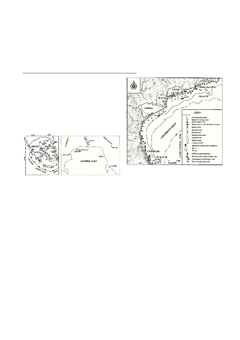
The study area, located in southeastern Peloponnesus, extends along
the shores of the northern Laconic gulf (Fig. 1). Geomorphologically
the broader area of southeastern Peloponesus have been studied by
several researchers (1,2,3). Morphotectonicaly, the gulf and its north-
ern extension form an asymmetric graben situated between the moun-
tain masses of Parnonas (1935m) in the east and Taygetos (2407m) in
the west. Regarding the tectonics, step like normal faults having NW-
SE directions and dipping to the NE are observed in the west, while in
the eastern part the big normal fault of Molai with a NE-SW direction
and a SE dip exists. The morphological and the archaeological obser-
vation suggest that these faults have been reactivated in historical
times. Moreover the area is characterized by intense seismicity, as
strong disastrous earthquakes have been reported since ancient times,
indicating recent tectonic activity.
On both sides of the Laconic gulf and especially in the area of Plytra
in the east and at Gythio, Valtaki and Mavromadilou in the west (4,5),
submerged archaeological remains from Classical to Byzantine times
have been observed in the sea as deep as 5m. Furthermore, 3km inland
from the the mouth of Eurotas river at the head of the Laconic gulf,
archaeological reports indicate the existence of the port (Elos) of the
ancient city of Sparta (6). In the present study, detailed coastal geo-
morphological mapping was performed in relation to the location of
archaeological sites (Fig. 2), in order to determine which of the two
factors, eustatism or tectonism, is primarily responsible for their sub-
mergence.
Archaeo-geomorphological observations
Gythio, the harbor of ancient Sparta was in use since the Homeric
times and served the hinterland till the Roman times. Although seve
r
a
l
e
a
r
t
h
q
u
a
kes shook the town the worst one happened in 375 A.D. and
the sea covered a considerable part of the town. Nowadays submerg
e
d
ruins are observed down to 5m depth. Valtaki, In the Holocene, follow-
ing the stabilization of sea level around 5000 BP, the E-W ?ow of the
longshore drift formed a sand spit which extended westwards resulting
to the formation of a small lagoon behind it. Eve
n
t
u
a
l
l
y, the ?u
v
i
o
-
t
o
r-
rential sediments filled most of the lagoon leaving a small marshy area.
In the western part of the sand spit, near the springs (Glyfada), Roman
and early Byzantine ruins extend into the sea down to a depth of about
2m. Over them, coastal dune fields have developed reaching to an ele-
vation of about 4m. The most recent formation is the beachrock which
c
overs the archaeological remains and is located in the present inter-
tidal zone but eroding today.In Plytra, part of the classical city of
Asopos, is submerged at depths of around 2m. The overlying Roman
and early Byzantine ruins at above present sea leve
l
.
Conclusion
It is evident that this area has been submerged in recent times, but
is it is still difficult to distinguish the proportional contribution of
eustatism and tectonism. However archaeological sites of the same age
has not submerged with the same rate. Ruins of Classical time at
Gytheio in the west are found much deeper (5m) than in Plytra in the
east (2m), indicating tectonism is much more significant factor in the
relative sea level change in the last 2000yrs. The reactivation of local
normal faults has played the predominant role. The plane of Eurotas
evolved differently because of the important sedimentation of the
Eurotas river.
This study shows that geomorphological mapping combined with
archeological observation could provide valuable conclusions con-
cerning the recent geomorphological evolution of the area.
References
1- Dufaure J.J., 1975. Le relief du Peloponnese, These, Univ. Paris IV.
2- Kelletat D. and Gassert D,. 1975. Quartarmorphologische unter-
suchungen im kustenraum der Mani-Halbinsel, Peloponnes. Z.
Geomorph.N.F., Suppl.-Bd.22, 8-56.
3- Kowalczyk G., Winter K.P., Steinich G. and Reisch L., 1992.
Jungpleistozane strandterrassen in sudost Lakonien (Peloponnes,
Griecheanland), Schriftenreihe fur geowissenschaften, 1/1-72.
4-- Negris P,. 1904. Vestiges antiques submerges. Athenisher
Mittelilungen,29, 340-363.
5 - Scoufopoulos-Stavrolakis N., 1985. Ancient Gythion, the Port of
Sparta: History and survey of the submerged remnants. In Harbour
Archaeology, Proceed. of the 1st Intern. Workshop on Ancient
Mediterranean Harbours, Caesare Maritima. Edt A. Raban. 49-62.
6 - Kraft J., 1972. A reconnaissance of the geology of the sandy coastal
area of Eastern Greece and the Peloponnese. Univ. of Delaware.
7 - Flemming N.C., 1968. Holocene earth movements and Eustatic sea
level change in the Peloponnese. Nature, 217, 1031-1032.
RECENT COASTAL CHANGES IN THE NORTHERN LACONIC GULF, GREECE,
BASED ON GEOMORPHOLOGICAL AND ARCHAEOLOGICAL EVIDENCE
K. Gaki-Papanastassiou
1
*, H. Maroukian
1
AND D. Papanastassiou
2
1
Department of Geography-Climatology, University of Athens, Greece
2
Institute of Geodynamics, National Observatory of Athens, Greece
Abstract
The Laconic gulf is located in southeastern Peloponnesus and is characterized by intense seismicity with many strong disastrous earth-
quakes reported since ancient times. Moreover the gulf forms an asymmetric graben situated between the mountain masses of Parnonas in
the east and Taygetos in the west, showing signs of active tectonics. On both sides of the Laconic gulf, submerged archaeological remains
from Classical to Byzantine times have been observed in the sea as deep down to 5m. Detailed coastal geomorphological mapping was
performed in relation to the location of archaeological sites, in order to determine whether eustatism or tectonism, is primarily responsi-
ble for their submergence.
Keywords:Tectonics, Geomorphology, Sea level, Coastal process, Aegean Sea
Figure 1. Location of the study area within Greece and main
localities discussed in the text.
Figure 2. Coastal geomorphological map of the study area