Rapp. Comm. int. Mer Médit., 36,2001
34
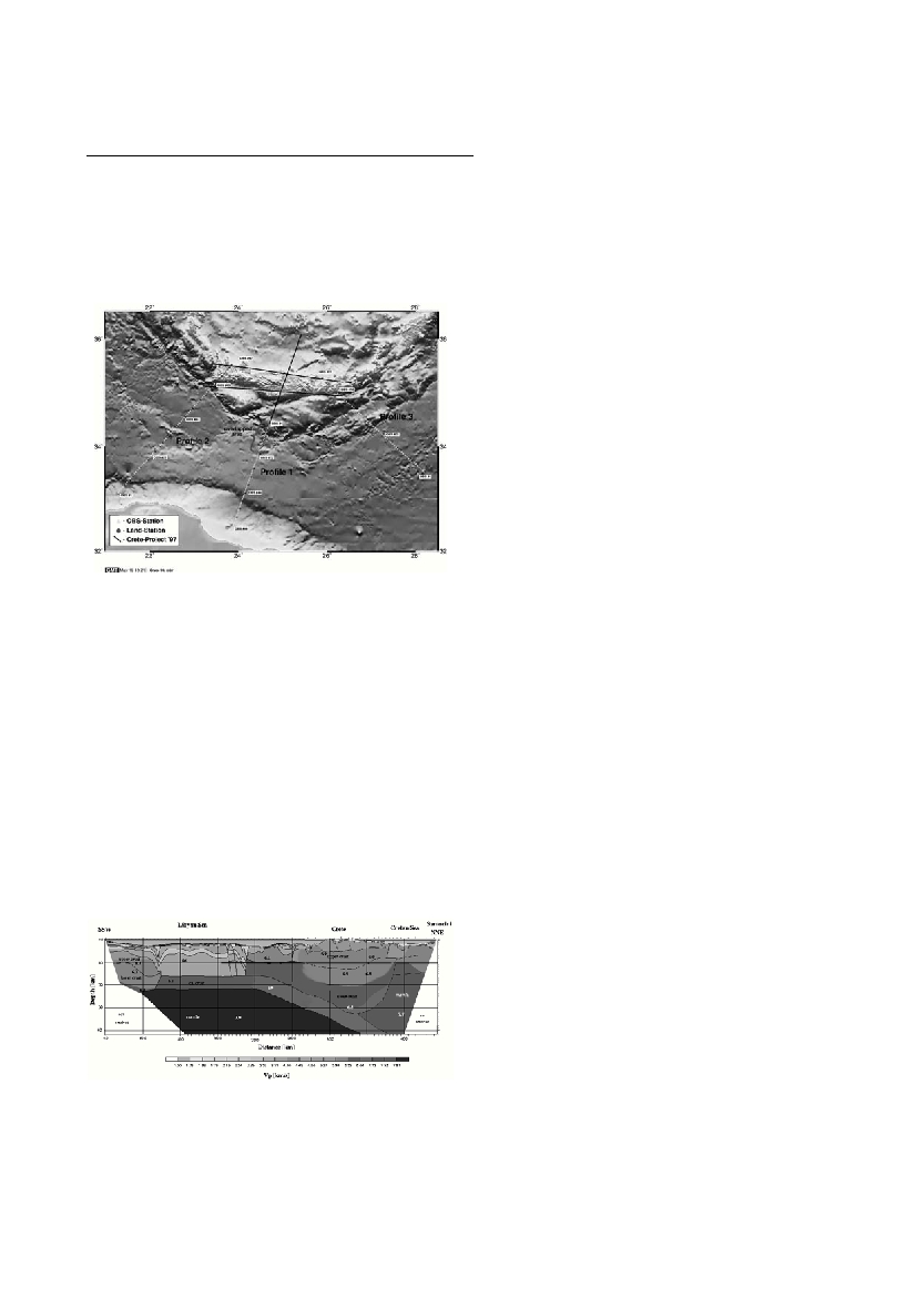
The crust and upper mantle structure of Crete, the Cretan and
Libyan Seas were obtained by two onshore-offshore seismic experi-
ments performed in 1997 and 1999. Onshore we deployed up to 100
stand alone digital seismic stations and offshore 67 OBS. They were
used to record seismic energy generated by a 3050 cubic inch airgun
array. Six seismic profiles were recorded and approx. 700 locations
were occupied by the onshore-offshore seismic stations (Figure 1).
Technical details of both experiments have been described obtained at
Bohnhoffet al.[1] and Broenner and Makris [2].
Crustal structure on Crete proved to be laterally very variably.At the
central part of Crete the crustal thickness exceeds 30 km whereas to
the east and west the continental crust thins to approx. 26 km and to
the east 22 km. In general the southern part of the island is thinner than
the northern part of it and even at central Crete obtains values of the
order of 29 km. To the north of Crete (Cretan sea) the continental crust
does not exceed 16 km at its thinnest part and seems to be associated
with transtensional processes that created pull apart basins (see also
[3]). The sediments in the Cretan sea do not exceed 5000m and high
velocity metamorphic limestones partly exposed on Crete do not seem
to be present. On Crete the metamorphic limestone formations
(Plattenkalk) have variable thicknesses ranging between 3 and 5 km.
Their compressional velocities have values between 5.7 and 6.0 km/s.
Below Crete we could identify in western and central Crete a second
crustal layer of 5 to 6 km thickness which is clearly separated by the
continental crust by first order discontinuity mapped due its good
re?ectivity.This layer was interpreted as oceanic crust of the Ionian
domaine which is presently subducted below Crete. The decoupling of
this layer from the continental crust occurs at the north-eastern part of
Crete and the decoupling front is northwest-southeast oriented. It
delineates the down dipping slab of oceanic lithosphere that generates
the volcanic arc of the southern Aegean sea (Figure 2).
South of Crete the continental crust extends 100 - 150 km south and
southwest of the Cretan coast and has been partly tectonized by the
Ptolomeus and Pliny fault systems which are also associated with
extensional structures. These propably involve strike slip as well as
normal faulting. The crust of the Libyan sea which was mapped south
of the Pliny fault is composed of oceanic crust and covered by thick
sediments. Along the Mediterranean Ridge they exceed in some areas
12 km in thickness. This part of the Libyan sea is very strongly fold-
ed and faulted, expressing the intense tectonic deformation ongoing at
present. In this part of the Mediterranean Ridge we have not identified
high velocity limestones of the Plattenkalk type as those exposed on
Crete or other Parts of the Hellenic Arc. Compressional wave veloci-
ties of 4.5 - 4.8 km/s denote the existence formations that have not
been subjected to significant metamorphism. In most of the Libyan sea
we identified one inversion zone of 3.0 -3.2 km/s underlying the 4.2
km/s limestones. In some parts two inversion zones have been
mapped.
The African continental crust extends north to northeast for more
than 100 km off the Libyan coast. This part of the crust is strongly
thinned (25 -22 km thickness) and covered by thick sediments which
are more intensely deformed to the west than to the east of Cyrenaica.
Along our western profile we identified thick sedimental basins at the
Libyan offshore areas that contain more than 8000m of sediments and
are truncated to the northeast by intense faulting. By comparing the
eastern profiles with the western line described above, we see that the
intense tectonization is closer to the eastern Cretan coast than to its
western side. In general whereas south of Crete the continent- ocean
collision is oblique, to the west the subduction is oriented parallel to
the Hellenides and of northeast- southwest orientation.
References:
1 - Bohnhoffet al., 2000, Crustal investigation of the hellenic subduction
zone using wide aperture seismic data, in Press
2 - Broenner M. and Makris J., 2000. Crustal structure of the Libyan
margin.C
IESM
Workshop Series, 13: 63- 66
3 - Goetz L.G., 1996, Beschreibung und Vergleich der Tektonik pazifisch-
er und mediterraner Back- arc Becken hergeleitet aus echographischen
und bathymetrischen Vermessungen, Bericht aus dem ZMK, Reihe C:
Geophysik, Nr. 9
CRUSTAL SHORTENING ALONG THE CRETAN ARC OBTAINED BY ACTIVE SEISMIC EXPERIMENTS
Jannis Makris*, Marco Brönner
Institute for Geophysics, Hamburg University, Hamburg, Germany - makris@dkrz.de
Keywords: crustal mapping, tectonics, Crete, Libyan and Cretan seas
Figure1:Crete-Projekt,DistributionofOBS-andLand-
Figure 2: 2D Velocity- Depth model from the rim of Africa
across Crete to Santorini, vertical exaggeration: 3.0