Rapp. Comm. int. Mer Médit., 36,2001
41
ACTIVE DEFORMATION AND MICROSEISMICITY OF THE MESSINIAKOS GULF, SOUTHERN GREECE,
DEDUCED FROM AN ONSHORE/OFFSHORE LOCAL SEISMIC ARRAY
J. Papoulia
1
* and J. Makris
2
1
Institute of Oceanography, National Center for Marine Research, Athens, Greece - nana@ncmr.gr
2
Institute of Geophysics, University of Hamburg, Germany - makris@dkrz.de
Abstract
The microseismic activity in the area of Messiniakos gulf, southern Greece, was observed by an onshore/offshore seismic array. In a peri-
od of 45 days more than 1600 events were detected and the distribution of the seismic activity confirms the existence of an active fault
system of NW-SE orientation correlating with tectonic elements mapped by geological techniques. It is of particular significance that in
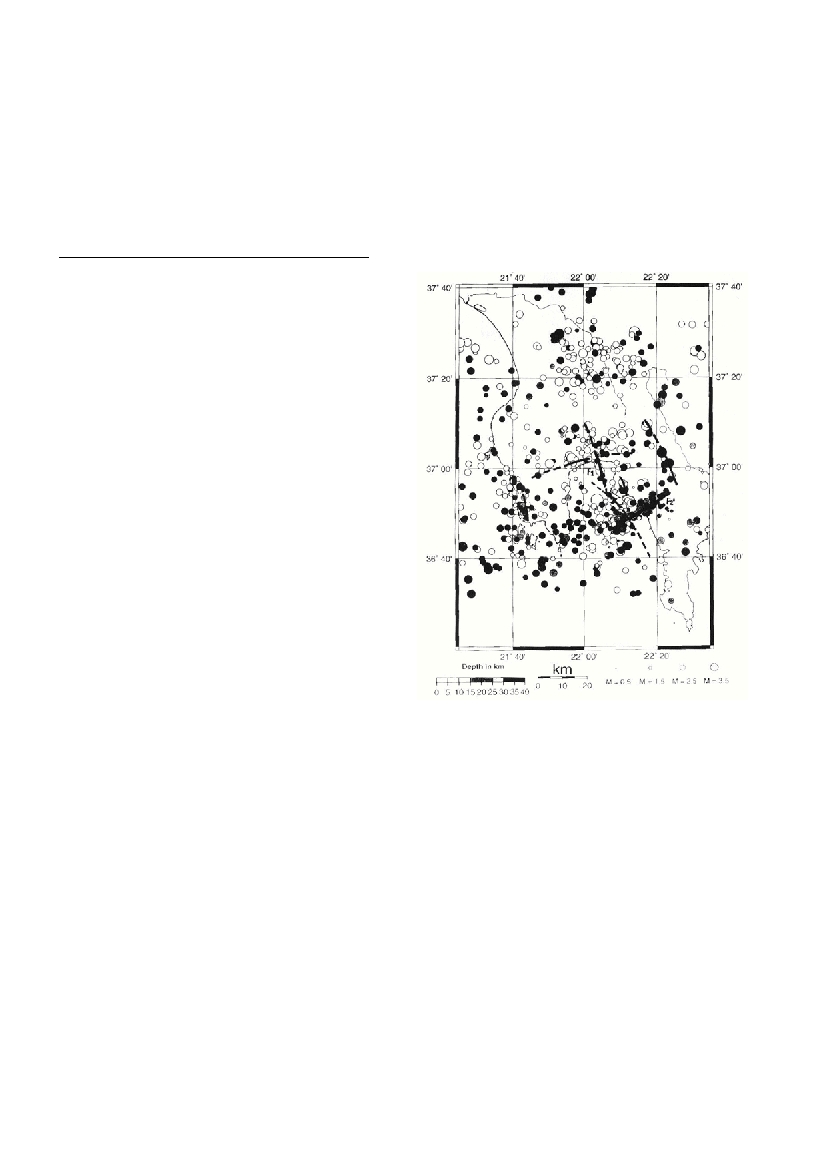
the immediate vicinity of the city of Kalamata the distribution of epicenters delineates an NW-SE fault (F1, Fig.1) which coincides with
the fault system activated during the 1986 M6.0 catastrophic earthquake. Apart from this a deep fault of NE-SW orientation was mapped
in the lower part of the Messiniakos gulf (F2, Fig.1) which is associated with the subduction process below southwestern Greece.
Keywords : active tectonics, microseismicity, southern Greece
Introduction
After the destructive Ms6.0 earthquake of Kalamata, southwestern
Greece, of September 13, 1986, that caused significant economic dam-
age and human losses, several investigations were initiated aiming at a
more precise location of the active fault systems in order to better esti-
mate the seismic hazard and risk of the broader Messiniakos area. In
this respect particular interest was given to the study of the poorly
understood submarine tectonic elements of the Messinian bay and
their connection to the onshore tectonics (1). In an attempt to better
locate the offshore active faults of this region, a combined onshore/off-
shore microseismicity survey of 30 seismic stations was carried out in
the Messiniakos Gulf, by the above mentioned Institutes. The correla-
tion of microseismicity with regional tectonics is discussed in the pre-
sent study.
Microseismicity
We deployed 20 stand alone seismic units onshore that recorded
continuously for 45 days three seismic channels at a sampling rate of
8 msec (2). Data were stored on hard disk and the timing and position
were obtained by an intergrated GPS system. 10 ocean bottom seis-
mographs (OBS) were used for the offshore observations. These sys-
tems have the same recording capacity as the land stations, are housed
in a glass sphere and can be deployed to water depths over 6,000 m.
Timing is obtained by a thermal stabilized quartz clock. The OBS are
anchored on the sea ?oor by a specially designed weight and can be
released from it acoustically or by a timing device (3,2).
In a period of 45 days, in Fall 1999, more than 1600 events were
detected. In the immediate area of interest about 930 events were
located (fig. 1) with an accuracy better than 3 Km in the epi- and
hypocentral position. Their local magnitudes callibrated by records of
the National Seismograph Network of Greece ranged between ML1.2
and 4.0.
Discussion and conclusions
The distribution of the foci delineated mainly two active fault zones
in the Messiniakos basin and one onshore the northern costal area, and
particularly the city of Kalamata. The main offshore active tectonic
element strikes NE-SW and terminates in the area of Kardamili. This
part of the Taigetos peninsula is truncated by a NW-SE major tecton-
ic fault which is also characterized by high seismic activity. More
important however is the identification of an active fault zone, south of
the city of Kalamata. Its proximity to this densely populated urban
center creates a hazardous situation that has to be considered in any
major urban planning and construction. A dense distribution of deep-
er events in the lower part of the Messiniakos gulf is associated with
the subduction process which takes part in southwestern Greece, at an
approximately 50 km distance from the study area. The western coast
of the Messinian bay is less affected by seismic activity and only at the
southernmost part of the peninsula an NS striking active fault system
has been identified. A large number of seismic events were located
outside the local network. Their accuracy, particularly that of the
hypocentral depth, is smaller than that within the array. In spite of this
shortcoming, the strong Athens ML5.9 earthquake of September 7,
1999, has been recorded including all the foreshock and part of ist
aftershock activity.The larger events identified two active zones. One
is striking E-W with the Athens main shock at ist center, having a
length of approximately 20 Km. The second one, striking NE-SW,
extends all the way from the Parnis mountain over the island of
Salamina to the eastern coast of Peloponnese. The Saronic bay is trun-
cated along this line by an active fault. A new research program was
recently initiated aiming at the more precise location of the seismic
activity of the Saronic area.
References
1. Papanikolaou D., Chronis, G., Pavlakis, P. and Lykousis, V., 1988.
Submarine neotectonic map of Upper Messiniakos Gulf, Edition
Earthquake Planning and Protection Organization, Athens.
2. GeoPro, 1995. SEDIS IV: a compact digital recorder for seismic sur-
veys.
3. Makris J. and Möller L., 1990. An ocean bottom seismograph for gen-
eral use. Technical requirements and applications. In proceedings of
Symposium Europe and the Sea“, Hamburg (Ed. Hoefeld, J., Mitzlaff, A.,
Polomsky, S.).
Fig.1.Microseismicity of Kalamata 99 (number of events :