Rapp. Comm. int. Mer Mťdit., 36,2001
43
Introduction
The Gulf of Corinth is the most active extensional feature in Europe
with a maximum extension rate in N-S direction of 7-16 mm/yr (1,2).
With a general WNW-ESE elongate shape, the Gulf of Corinth sepa-
rates the clockwise rotating Peloponese to the south from the relative-
ly stable Central Greece to the North. The up to 900m deep basin
crosscuts the NNW-SSE trending alpine structure of the Hellenides,
limiting the occurrence of Parnass unit to the North and the external
metamorphic belt to the South, and disrupting the nape structure of
Pindos unit.
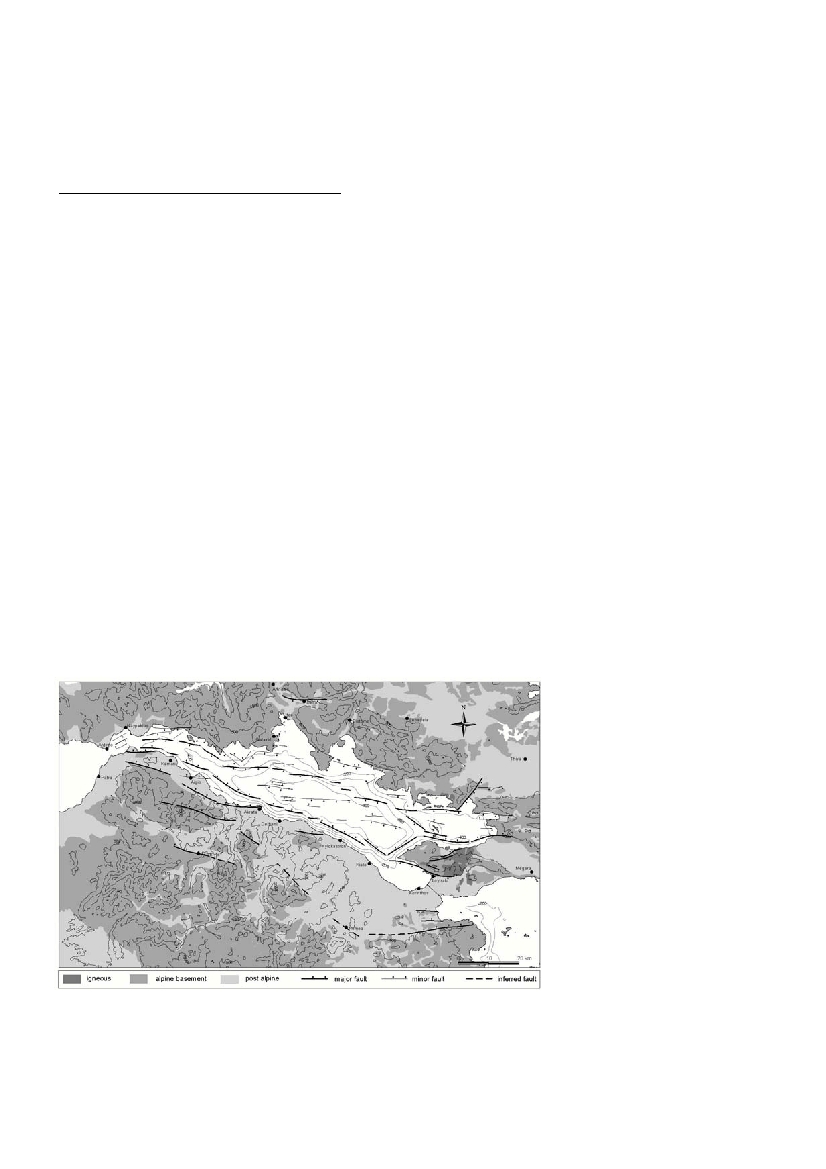
Faulting and evolution
A grid of densely spaced (every 1 mile) N-S single-channel Air Gun
p
r
o
files was performed in the entire Gulf of Corinth (from Rion-
Antirrion to the Gulf of A
l
kyonides) and provided maximum penetration
of 1sec twtt within the basinís sediments and relatively high-resolution.
The present Gulf-of-Corinth basin is controlled by two main
marginal fault zones, which run along the foot of the southern and
northern submarine slopes. Each fault zone consists of a number of E-
W trending, en echelon arranged, fault-segments. Both slopes are
steep and display extensive failure phenomena. In contrast to the pro-
posed asymmetric character of the basin (3), favoured by most work-
ers up to now, the structure of the present-day Gulf of Corinth appears
much more complicate.
Starting from the East, the Psatha fault and its westward prolonga-
tion along the foot of the southern slope controls the evolution of the
Gulf of Alkyonides basin. Both the sea-bed and the sediments dip
southwards, while the lowermost horizons of the 400m thick basin
infill are correlated with the Pleistocene conglomerates of the inactive
Megara basin, presently exposed at 300m altitude (4).
Moving to the West, the 800-900 m deep basin of the central Gulf
of Corinth displays rather symmetric character.The basin infill con-
sists of continuous turbidite sedimentation and is intersected by nar-
row zones of transpressional deformation, bordered by E-W trending,
intra-basinal, high-angle faults. Massive sliding structures occur all
along the steep southern and northern slopes. The Perachora peninsu-
la, which is bordered by the NW-facing Perachora fault and the S-ward
dipping Loutraki fault, separates the central basin of the Gulf of
Corinth from the N-ward tilted Lechaion Gulf basin.
Further to the West the active Gulf of Corinth basin becomes sig-
nificantly narrower and shallower, while the maximum sediment accu-
mulation thickness decreases gradually from >800m in the eastern part
to <400m offAigio. Between Galaxidi and Aigio the basin infill con-
sists mainly of chaotic slide masses, while continuous sedimentary
re?ectors are poorly observed. The lower horizons of the sedimentary
sequence are strongly deformed and dip gently to the N, indicating a
possible N-ward tilting of this part of the basin.
The westernmost part of the basin is occupied by the prodelta and
distal deposits of Erineos and Mornos rivers. Frequent slope failure
phenomena occur along both the southern and northern 200m high
escarpments, which border the narrow basin.
The southern margin of the present Gulf undergoes continuous
uplift, indicated by the presence of elevated marine terraces (5,1), and
the uplifted Pleistocene delta deposits in Northern Peloponese (6).
Opposite to that, the northern margin of the Gulf undergoes continu-
ous subsidence during the last 250 ka, as shown by the presence of
several low-sea-level-stand prograding sequences on the outer self and
upper slope off Eratini (7).
Discussion
The present Gulf of Corinth represents the last stage of an older
structure, which initiated in Upper Miocene Ė Lower Pliocene. The
opening of the basin either started earlier in the eastern part or pro-
graded faster in the east than in the west. This assumption may explain
the widening, deepening and higher sediment accumulation of the
basin toward East and coincides with the clockwise rotation of
Peloponese. During the evolution of the basin the southern active mar-
gin was migrating northwards and the northern one remained more or
less stable inducing northward shifting of the active basin. The rather
complicate structure of the present day Gulf of Corinth basin is not
easily explained by the presence of a low-angle N-dipping normal
fault / seismogenic layer below the Gulf, which is proposed by many
authors.
References
(1) Armijo R., Meyer B., King G., Rigo A. and Papanastassiou D., 1996.
Quarternary evolution of the Corinth rift and its implications for the late ceno-
zoic evolution of the Aegean. Geoph. J. Int.,
126/1: 11-53.
(2) Davies R.R., England P.C., Parson B.E.,
Billiris H., Paradissis D. and Veis G., 1997.
Geodetic strain of Greece in the interval
1892-1992.J. Geophys. Res., 102: 24,571-
24, 588.
(3) Brooks N. and Ferentinos G., 1984.
Tectonics and sedimentology in the Gulf of
Corinth and Zakynthos and Kefallinia
chanels, western Greece. Tectonoph.,101:
25-54.
(4) Sakellariou, D., Lykousis V. and Papani-
kolaou D., 1998. Neotectonic and evolution
of the Gulf of Alkyonides, Central Greece.
Bull. Geol. Soc. Greece, 32/1: 241-250.
(5) Keraudren B. and Sorel D., 1987. The ter-
races of Corinth (Greece) - A detailled record
of eustatic sea-level variations during the last
500,000 years. M
a
r. Geol., 77: 99-107.
(6) Ori G.G., 1989. Geologic history of the
extensional basin of the Gulf of Corinth
(?Miocene- Pleistocene). G
e
o
l
og
y, 17: 918-921.
(7) Lykousis V., Sakellariou D. and Papani-
kolaou D., 1998. Sequence stratigraphy in
the N. margin of the Gulf of Corinth:
Implications to Upper Quaternary basin evo-
lution.Bull. Geol. Soc. Greece, 32/2: 157-
164.
ACTIVE FAULTING IN THE GULF OF CORINTH, GREECE
D. Sakellariou*, V. Lykousis and D. Papanikolaou
National Centre for Marine Research, Athens, Greece - sakell@?.ncmr.gr
Abstract
High resolution seismic profiling in the Gulf of Corinth indicates more complicate structure than thought up to now.Two equivalently
active fault zones, each one composed of several en echelon arranged fault-segments, border the basin north- and southwards. The basin
becomes narrower and shallower toward west, while significant transpressional deformation occurs along narrow zones.
Key words : Tectonics, Stratigraphy, Seismics, Sea Level
Fig. 1: Active faulting in the Gulf of Corinth basin.