Rapp. Comm. int. Mer Médit., 36,2001
58
Introduction
One of the activities within the Mediterranean Forecasting System Pilot
Project (MFSPP) consists in developing techniques and nested models to
downscale the hydrodynamics to the shelf areas of the Mediterranean Sea
[1]. The strategy is to downscale the large scale Ocean General Circulation
Model (OGCM) (
˜
12.5Km resolution) ?ow field into an intermediate
model with 5Km resolution. This intermediate model is implemented in
the Sicilian Channel area [2]. The ?ow field from the intermediate model
is further downscaled to the Malta shelf area with a resolution of 1.2Km.
Both the intermediate and shelf model implementations are based upon the
Princeton Ocean Model [3]. POM is a free surface, baroclinic, sigma-coor-
dinate model that uses a time splitting technique to solve the depth inte-
grated and the full 3D equations with different time steps. The vertical
eddy viscosity/diffusivity parameters are calculated by an embedded 2
nd
moment turbulence closure [4]. The horizontal grid uses an ‘Arakawa C’
differencing scheme.
Model set up
The shelf model is implemented in the area spanning 13.8°E to 15°E
longitude and 35.45°N to 37.1°N latitude, with a spatial resolution of 1/60°
x 1/60° (71 x 107 grid points) and 15 sigma layers (bottom following) with
logarithmic distribution near the surface. The model is closed at the north-
ern boundary by the Sicilian coast and open at the western, southern and
eastern boundaries. The average computational grid size is 1493m along
latitude and 1853m along longitude. The U.S. Navy Digital Bathymetric
Database 1 (DBDB1) with a 1/60° x 1/60° resolution is used for the com-
putation of depth at each grid cell using bilinear interpolation. The maxi-
mum depth of 1054m to the SW of Malta limits the external courant time
step to 4s. The shelf model is initialised from rest with T/S fields from the
intermediate model.
Surface boundary condition
The monthly mean surface ?uxes are taken from the climatological
atmospheric forcing data set derived from the ECMWF Re-Analysis data
set (ERA) for the period January 1979 to December 1993, initially mapped
on a regular grid with a horizontal resolution of 1 degree for the
Mediterranean Sea. The adopted momentum, heat and salt surface bound-
ary conditions are:
where
t
is the wind stress, Qsol is the solar radiation, Qup is the upward
heat ?ux, r is the density and Cp is the specific heat capacity at constant
pressure. The heat and salt ?uxes are relaxed to the monthly climatology
given by the Med-6 data set, using a ?ux correction term with C
1
=25W/m
2
°C and C
2
=0.7m day
-1
respectively.T* and S* are the monthly averaged
climatological sea surface temperature and salinity, while T and S are the
model first level temperature and salinity, respectively.The relaxation is
that proposed by Zavatarelliet al.[5].
Lateral boundary conditions
The open boundary conditions are provided through one-way nesting to
the Sicilian Channel Intermediate Model. The nesting of temperature, salin-
ity and velocities (total and barotropic) is necessary in order to transfer va
l-
ues from the coarsely spaced grid to the finely spaced grid at the location of
boundary region. The grid nesting ratio is 3. The ten-days averaged fie
l
d
s
from the intermediate model are interpolated in space over the higher reso-
lution grid and linearly in time at each time step through an off-line, one-
way nesting. The internal and external normal velocities to the boundary are
directly specified from the coarse resolution model. The tangential compo-
nent velocities at the boundary are set to zero. In this specification the mass
transport at the open lateral boundary is constrained to be equal to that pre-
scribed from the coarse model at each respective open boundary
where U is the coarse grid total velocity field, U is the interpolated veloc-
ity field, hcoarse and hhigh are the respective bathymetries of the coarse
and high resolution grid model. The free surface elevation is not nested
(zero gradient boundary condition), while an upstream advection is used
for temperature and salinity:
In the case of out?ow through the open boundaries, temperature and salin-
ity are prescribed from the coarse model.
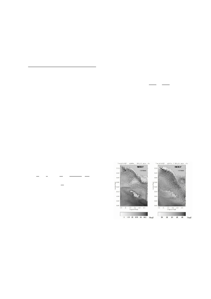
Results
The ability of the model to reproduce a realistic circulation of the
Siculo-Maltese shelf area is brie?y examined. The main general circulation
patterns are well reproduced with seasonal variability in both spatial extent
and ?ow intensities. The model replicates the results of the intermediate
model with additional mesoscale detail. This is exemplified by the veloci-
ty and temperature fields plotted in superposition for January and July in
Fig.1 at 5m. During winter the temperature field is characterised by a sharp
line of demarcation running in a SSE direction parallel to the axial orien-
tation of the Maltese Islands. This is corroborated by satellite thermal
infra-red images of the area. The surface velocity field is dominated by the
Atlantic Ionian stream which is present throughout the year with signifi-
cant seasonal modulation. During winter it follows closely the Sicilian
coast up to 14.4°E longitude after which it detaches in a SE direction fol-
lowing the bathymetry. During summer this ?ow intensifies in magnitude
and horizontal extent carrying a streak of relatively fresh water along its
main axis; it spreads southwards and engulfs and ?ows around the Maltese
Islands. The stream is accompanied by a persistent cyclonic pattern south
of the eastern tip of Sicily which is enhanced during summer and occurs in
association to density gradients produced by the intrusion of more saline
water from the Ionian. At 280m the circulation is dominated by the west-
ward ?ow of LIW to the south of Malta. This ?ow is most intense during
winter and becomes slightly cooler during summer.
Acknowledgements.This work was conducted as part of the Mediterranean Forecasting
System Pilot Project (MFSPP) and supported by the EU-MAST Programme (contract
MAS3-CT96-5019).
References
1. Pinardi N., 1998, The Mediterranean Forecasting System Pilot Project, Scientific and
Technical Plan, Package II, 92pp.
2. Sorgente R. and Zavatarelli M., 1999. Seasonal Circulation in the Strait of Sicily. In:
Proceedings of the 2nd EuroGOOS Conference, March 1999.
3. BlumbergA. F. and Mellor G.L., 1987. A description of a three-dimensional coastal
ocean circulation model. In: Three Dimensional Coastal Ocean Models, Coastal Estuarine
Science, (N. S. Heaps, Ed.). AGU, 1-16.
4. Mellor, G.L., YamadaT., 1982. Development of a turbulence closure model for geo-
physical ?uid problems.Rev. Geophys. Space Phys. 20, 851-875.
5. Zavatarelli M., N. Pinardi, V.H. Kourafalou and A. Maggiore, 2000, Diagnostic and
prognostic model studies of the Adriatic Sea general circulation. Submit. toJ. Geo. Res.
A ONE-WAY NESTED HIGH RESOLUTION CIRCULATION MODEL IN THE MALTA CHANNEL
Aldo F. Drago
1
* , Roberto Sorgente
2
1
Physical Oceanography Unit, IOI-Malta Operational Centre, University of Malta, Msida, Malta - adra1@um.edu.mt
2
CNR-S2AM, c/o International Marine Centre, Oristano, Sardinia, Italy - sorgente@barolo.icb.ge.cnr.it
Abstract
A high resolution (1.2Km) eddy-resolving 3D prognostic numerical model based on the Princeton Ocean Model (POM) is used to simu-
late the seasonal circulation in the Malta Channel with perpetual year “climatological” forcing and with one-way nesting to an intermedi-
ate coarser resolution model (5Km) implemented over the Sicilian Channel area. The coupling between the two models is explained. The
general results of this experiment are presented to assess the performance of the model.
Keywords: coastal models, circulation, Sicilian Channel
Figure 1. Model velocity and temperature at 5 mn during (a) winter, and
k
M
?
r
u
?
z
?=
0
=
r
t
?
k
H
?
T
?
z
?=
0
=
(Q
sol
-
Q
up)
?
C
p
+
C
1
?
C
p
(T
*
-
T
)
k
H
?
S
?
z
?=
0
=
S(E
-
P)
+
C
2
(S
*
-
S)
U
total
high
dldz
=
U
total
coarse
dldz
hcoarse
?
?
l1
l2
?
hhigh
?
?
l1
l2
?
?
T,S
()
?
t
+
U
?
T,S
()
?
x
=
0