Rapp. Comm. int. Mer Mťdit., 36,2001
62
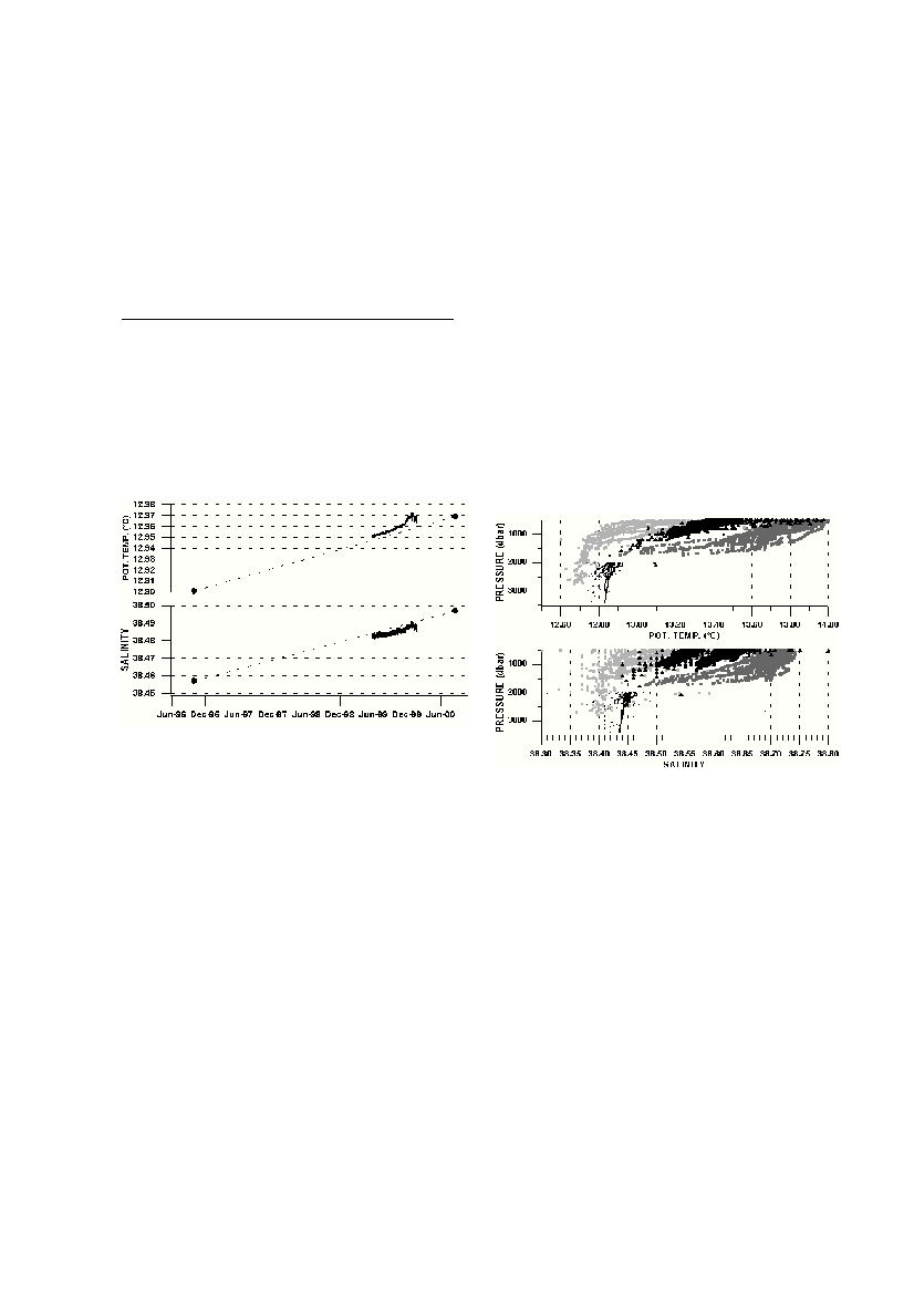
From June 1999 to February 2000, a few-metre mooring supporting
a Seacat SBE16 (T/C accuracy-resolution of 0.01-0.001įC/ 0.001-
0.0001 S.m
-1
) was set at ~3505 dbar, ~25 km North-East of Ustica, as
a preliminary survey to the deployment of the GEOSTAR observatory
[1]. Both the temperature and salinity time series increased tremen-
dously and almost continuously (fig. 1) by ~0.012įC/8 months and
~0.007psu /8 months. The idea that the 8-month trends re?ected a sev-
eral-year phenomenon is supported first by ship-handled SBE911+
profiles performed there ~4 years apart. The
?
/S bottom values were
~12.90įC/~38.46psu (at 3470 dbar) in October 1996 and
~12.95įC/~38.48psu (at 3440 dbar) in September 2000. These isolat-
ed values are remarkably aligned with the SBE16
?
/S ones.
Also, annual averages computed from the Medatlas database [2]
reveal that the
?
-S of the Tyrrhenian deep water (depth >3000m,
TdeepW hereafter) increased continuously during the 1909-1990 peri-
od, with slopes comparable (few 0.01įC-0.01psu / decade) to those
already reported for WMDW (Western Mediterranean Deep Water) in
the Algero-ProvenÁal Basin (e.g.[3]). Our observations complete the
historical data and demonstrate that the
?
-S of TDeepW markedly
increased during the last decade, with slopes up to ~10 times greater
than before (and than for WMDW now). Such dramatic trends put into
light the question of the origin of TdeepW which cannot be considered
as a mixture of waters having lower trends. Moreover, historical data
clearly show that TdeepW has always been warmer (~0.1įC) and salti-
er (few ~0.01) than the WMDW in?owing from the deepest part of the
Sardinia Channel (~2000m).
?
-S diagrams show that TdeepW cannot
be considered as a mixture of WMDW and waters originated from the
Eastern Mediterranean. We hypothesise that TDeepW might be gener-
ated by a deep water formation (DWF) process within the Tyrrhenian.
Up to now, it has been demonstrated [4] that, due to strong (and
cold, in winter) westerlies blowing through the Bonifacio Strait, the
region east of the strait was occupied by a year-round cyclonic gyre,
extending at depth and surrounding cold dense waters. Associated pro-
cesses invoked by [4] are an upwelling that enhances mixing of MAW
(Modified Atlantic Water) and LIW (Levantine Intermediate Water)
below, making the region a privileged place for vertical exchanges
between the different water masses. But, to our knowledge, DWF has
never been said to occur there.
We think that the stratification and circulation described by [4] east
of the Bonifacio Strait are very similar to what is encountered in the
Gulf of Lions where WMDW is formed. We note, as shown by fig. 2,
that the deep values of historical
?
and S profiles east of the Bonifacio
Strait (E9į-12į/N 41į-42į) display a striking continuity with the deep-
estTyrrhenian values (depth >2000m), contrary to the profiles repre-
sentative of the water which comes from the Algerian Basin or from
the Eastern Mediterranean (profiles collected in regions E6į-
10į/N37į-38į and E12į-14į, N38į-38.5į, resp.). We also note that
TdeepW is warmer (+ ~0.1įC) than WMDW, which could be related
to LIW east of the Bonifacio Strait being saltier than in the Gulf of
Lions.We thus believe that these three features strongly support the
hypothesis of DWF east of the Bonifacio Strait.
References
1. Beranzoli L., Braun T., Calcara M., Calore D., Campaci R., Coudeville
J.M., De Santis A., Etiope G., Favali P., Frugoni F., Fuda J.L., Gamberi
F., Gasparoni F., Gerber H., Marani M., Marvaldi J., Millot C., Palangio
P., Romeo G., Smriglio G., (2000). European sea?oor observatory offers
new possibilities for deep-sea study. EOS, 81, 5, 45 and 48.
2. MEDATLAS Group, 1997. A Mediterranean Hydrographic Atlas from
a composite Quality checked temperature and salinity data , IFREMER
Ed. (3 CD-ROM).
3. Rohling, E., Bryden, H., 1992. Man-induced salinity and temperature
increases in the Western Mediterranean deep water.J. Geophys. Res. 97,
11191-11198.
4. Artale, V., Astraldi, M., Buffoni, G., Gasparini, G.P., 1994. Seasonal
variability of gyre scale circulation in the northern Tyrrhenian Sea. J.
Geophys. Research. 99, 14127-14137.
LARGE TEMPERATURE AND SALINITY TRENDS IN THE DEEP TYRRHENIAN AND ORIGIN
OF THE TYRRHENIAN DEEP WATER
Fuda J.-L.
1*
, C. Millot
1
, G. Etiope
2
, P. Favali
2
, G. Smriglio
2
, G. Rougier
1
1
LOB/CNRS, La Seyne, France - jlfuda@ifremer.fr
2
INGV, Roma, Italy.
Abstract
Large
?
-S trends (~+0.016įC.yr
-1
and ~+0.01 psu.yr
-1
) recorded with a CTD moored during 8 months at ~3400 m in the southern
Tyrrhenian are supported by CTD profiles performed there ~4 years apart and by historical data. Together with relatively large
?
-S values,
they allow questioning the origin of the Tyrrhenian Deep Water.We hypothesise that deep water formation process might occur in the
northernTyrrhenian.
Key-words:Tyrrhenian Sea, Temperature, Salinity, Deep waters
Fig. 1.
?
-S time series from SBE16. Black dots: terminal values
of 1996/2000 profiles.
Fig. 2.
?
and S profiles in the southeastern Algerian Basin
(light grey squares), east of the Bonifacio Strait (black tri-
angles), north Sicily (dark grey squares), and deep profiles
(>2000m) in the central Tyrrhenian (thin dots).