Rapp. Comm. int. Mer Médit., 36,2001
96
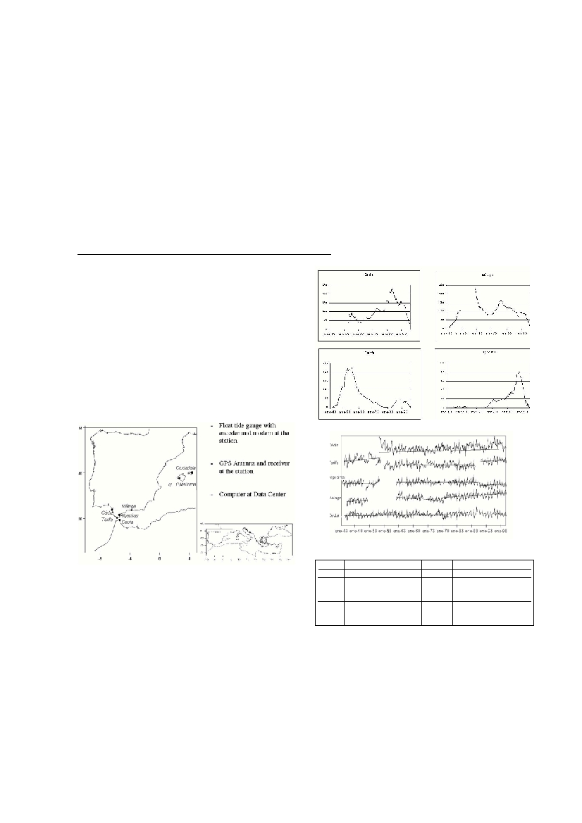
Technology and methodology
At this time, the complete sea level observing system, consist in 6 per-
manent tide gauge stations, 1 (or 2) permanent GPS stations and two Data
Centres, in the IEO and IGN respectively, fig. 1. Concerning to the sea
level, the measurement equipement is a mechanical ?oat gauge with a dig-
ital output system facility in addiction to the graphical output. The data are
received in the Data Centre in near real time by modem. The stations
around the peninsular coast are linked to the National Geodetic Levelling
Network. The mean sea level in P. Mallorca and Ceuta are the references
for the Levelling Network of the Island of P.M. and the City of Ceuta
respectively.The locations of these two stations are very strategy for the
spatial sea level topography. For that reason, these stations are included in
MEDGLOSS. The sea level data are received in the Data Centre and a sys-
tematic quality control is performed at annual basis, by using the USLC
software [6]. Later on in order to found the inhomogeneities in the whole
series, the Alexandersson’s homogeneity test, SNHT [7], has been per-
formed station by station. Then, with the reference homogeneous station
for the region, the Craddock’s test (1979) it is performing and the vertical
land movements will be remove by using the correction given by Peltier
[8],[9], for the final results.
Discussion of the time series
In fig. 2, the Alexandersson’s test shows: two inhomogeneity indicators
in Málaga (1961,1978), one in Algeciras (1956, 1990), two in Tarifa (1957,
1991). The dates when the inhomogeneities occur are corresponding,
mainly, with changes in places or equipement according to the historical
notes of each station. The trends have been calculated for the homogeneity
periods as presented in fig. 3 and table 1. The Craddock’s test is been pro-
cessing taking into account the results of the previous analysis and the his-
torical notes, for cross-checking.
References
1 - IOC, 1997. Global Sea Level Observing System (GLOSS). Implementation
Plan 1997. IOC Technical Series 50: 91 + Annexes.
2 - European sea-level Oberving System (EOSS). Status and future develope-
ments. Cost Action 40. Eur 19682
3 - Prieto J.F., Sánchez Sobrino J.A., Quirós Donate R., 2000. Spanish
National Reference Stations Network (ERGPS). The Tenth General Assembly
of the Wegener Projret Extended abstract book. Boletin ROA Nş 3/2000
4 - Tsimplis M.T, Baker T.F., 2000. Sea level drop in the Mediterranean Sea:
an indicator of deep water salinity and temperature changes ? Subm.
5 - Wo
o
d
worth P.L., 2000, Monitoring and Predicting Long term Global Sea Leve
l
Changes. Littoral 2000 5th Interntl conference. Period bio, Vol. 102 Suppl. 1.
6 - Caldwell P.C., 1998. Sea Level Dta Proccessing On IBM-PC Compatible
Computers. Version 3.0) ( Year 2000 Complaint.) JIMAR Contribution Nş 98-31
7 - Alesanderson H., 1986. A homogeneity test to precipitation data. Journal
of climatology, 6 : 661-171
[8] Peltier W.R, 2000. ICE4g (VM2) Glacial isostatic adjustment correction on Sea
L
evel rise, History and Consequences, Academic Press, New York, 228 pp.
9 - García Lafuente et al., 2000. Chap. 3. Determinación de Tendencias en
el nivel medio del mar a través de registros mareográficos. Draft Report.
SEA LEVEL OBSERVING SYSTEM IN THE WEST-WESTERN MEDITERRANEAN. IN THE PURSUIT OF
THE LONG-TERM CHANGES IN SEA LEVEL.CONTRIBUTIONTO MEDGLOSS
María Jesús García, Elena Tel, Joaquín Molinero
Instituto Espańol de Oceanografía, Madrid, Spain - Mjesus.garcia@md.ieo.es
Abstract
The sea level observing system presented in this paper is operated under the responsibility of the Instituto Espańol de Oceanografía (IEO).
It cover not only the strait of Gibratar: Ceuta (35ş 00’N, 05ş 36’W) in the African Coast, Tarifa (36ş 00N, 05ş 36’W), Algeciras (36ş 07’N,
05ş 19’W) in the European Cost, but also two other stations close to the strait: Cádiz (36ş 32’N, 06ş 17’W) in the Atlantic and Málaga (36ş
43’N, 04ş25’W) in the Mediterranean. Furthermore, the station in Palma de Mallorca (39ş 33’N, 02ş 38’E) is also included in this system
and Ciudadela will be operative very soon. All the station fulfil the GLOSS requirement and European Sea Level Observing System [1,
[2] and even in the stations of Ceuta and P. Mallorca there are (will be) installed a permanent GPS, under the IGN responsibility, for a con-
tinuos land monitoring [3]. The time series cover the period (1944-1999), except for P. Mallorca, but there are some lags. At present, the
complete period can not be used for the long-term change because there exist some inhomogeneities in the time series, then it is not pos-
sible to know that in this part of the Mediterranean the trend reduction after 60’s [4, 5] have been occur, but the present analysis shows
lower trend than in the Atlantic and even in some stations the trends are negatives. During this decade (90’s), the sea level has been
increased somewhat more than in the 80’s in most of the stations.
Key-words: Sea Level, Time series, Global Change,Western Mediterranean.
Table 1.Mean sea-level trend by period and stations.
S
t
a
t
i
o
nP
e
r
i
o
dtrend mm/yrs
t
a
t
i
o
nP
e
r
i
o
dtrend mm/yr
Cádiz
Feb 56-Dec 992.18
Ceuta
Mar 44-Dec 990.55
Tarifa
Jan 44-Aug 567.52
Málaga
Jan 45-Feb 527.47
Oct 57-Mar 91-0.62
Jan 62-Apr 78- 6 .66
Apr 91-Dec 995.80
May 78-Dec 994.99
Algeciras
Jan 43-Mar 561.81
Jan 62-Dec 90-0.06
Jan 91-Dec 994.90
Fig.1.Network.Geographical position and technology.
Fig.3.trends by station and by period.
Fig.2.Alexanderson test.Pointer of inhomogeneity