Rapp. Comm. int. Mer Médit., 36,2001
97
Introduction
MedGLOSS program (Mediterranean Global Sea Leve
l
Observation) was initiated 5 years ago [1], in order to join together
various national services dealing with the measurements of sea level
around the Mediterranean. Besides the network of existing tide gauges
operating along the coast and situated mostly along the northern part
(mostly based on the mechanical ?oat-type devices operating in the
stilling wells), a few of newer pressure gauges were installed after
1999, in particular in the Split harbour in June 2000. Herein will be
presented some applicability of the sea level data, installation proce-
dure of the gauge placed in Split harbour and some preliminary exam-
inations based on the pressure data collected there.
The data collected by the Split station will be useful within the cli-
matological studies in the Adriatic, particularly those dealing with the
global sea level rise, which is coming into focus over the last two
decades [2]. Sea levels on the time scale of several days (storm surges)
are also of typical interest nowadays; an example strongly emerges
when considering the ?ooding in the North Adriatic [3,4], particularly
in the Venice lagoon (so called “acqua alta”). In addition, free oscilla-
tion of the sea level, especially occurring within the semi-enclosed
basins and harbours, can endanger the safety of navigation [5].
Pressure gauge at Split harbour
Pressure gauge in the Split harbour was installed in June 2000, on
the pier close to the lighthouse placed at the harbour entrance. Such
position was chosen because of the requirements needed for the prop-
er work of the instrument, namely: (1) the sea is deep enough (mini-
mum 3 m below the Chart Datum) to put down the pressure sensor
deep enough to avoid the in?uence of the sea level oscillations in gen-
eral, (2) central unit has to be placed close to the sensor in a well pro-
tected location (here it is placed within the rocky walls of the light-
house), and (3) the place has to be protected in general from any other
source of eventual damage (sea traffic, people, …).
The equipment of the new stations includes an underwater pressure
sensor of Paroscientific Inc. manufacture, type Digiquartz Intelligent
sensor, model 8DP060-1 with an RS-232 communication cable; Setra
atmospheric pressure sensor, type 470, Garmin GPS II Plus Personal
Navigator unit with serial output and remote antenna for accurate time
recording, computer (Pentium II 350MHz computer with Windows 98
and 6 MB disk and US Robotics 32,000 baud rate modem), connec-
tions and power supply unit.
When installed, connection of the gauge to the geodetic reference
network was done by classical geodetic methods. As the old ?oat-type
tide gauge is placed approximately 1 km from the new one, Geodetic
Datum on the pressure gauge was acquired by using the existing
geodetic benchmarks on the way from the old gauge to the new one.
However, an error of 12 cm occurred as a result of the errors within the
geodetic network related to its oldness, but it is fixed by assuming that
the Chart Datum is the same at both locations.
The data are qualitatively analysed by using day-to-day analysis.
Thus, after more than 6 months of working, it can be said that the pres-
sure gauge worked properly in that time, without any problems.
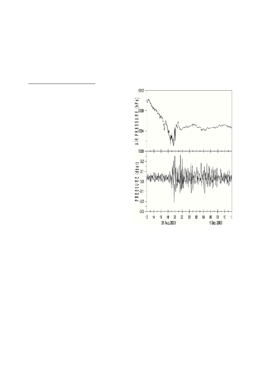
Moreover, the study of harbour seiches and resonance is performed4,
as a rather strong synoptic disturbance occurred over the area, exciting
very strong sea level response on the periods lower that 1 hour and
having amplitudes up to 40 cm. An example of filtered high-frequen-
cy series is displayed in Fig. 1.
References
1 -Rosen D. S., 1997. Physical aspects of the Mediterranean versus inte-
grated sustainable coastal and marine development. International Forum
“The Fragility of the Mediterranean Ecosystem, a Con?ict of Uses and
Resources”,Vilanova, Spain, 19 pp.
2 - Zerbini S., Plag. H-P., Baker T., Becker M., Billiris H., Burki B.,
Kahle H-G., Marson I., Pezzoli L., Richter B., Romagnoli C., Sztobryn
M.,Tomasi P., Tsimplis M., Veis G., Verrone G., 1996. Sea level in the
Mediterranean: a first step towards separating crustal movements and
absolute sea level variations,Global and Planetary Change, 14, 1-48.
3 -Robinson A.R., Tomasin A., Artegiani A., 1972. Flooding of Venice -
phenomenology and prediction of the Adriatic storm surge. Quarterly
Journal of the Royal Meteorological Society, 99, 686-692.
4 - Vilibic I., Leder N., Smircic A., Grzetic Z. 1995. Seiches inside the
Middle Adriatic islands, Workshop on "Mediterranean Sea - Circulation,
Strait Exchange and Dense Water Formation Processes", Trieste, October.
5 - Vilibic I., Mihanovic H., 2001. High-frequency sea level oscillations
observed and modelled in the Split harbour (Adriatic Sea). this volume.
MEDGLOSS PRESSURE GAUGE IN THE SPLIT HARBOUR:
INSTALLATION AND PRELIMINARYANALYSIS OF THE DATA
IvicaVilibic, Nenad Leder, Hrvoje Mihanovic, Ante Smircic, Zvonko Grzetic
Hydrographic Institute of the Republic of Croatia, Split, Croatia - dhi-oco@dhi.tel.hr
Abstract
The paper reports on the installation procedure and some preliminary results based on the data collected at the MedGLOSS pressure gauge
installed in the Split harbour in June 2000. Some problems related to the levelling procedure are discussed. In addition, applicability of
the sea level data is stated, and some preliminary results based on the data is presented.
Keywords: Adriatic Sea, sea level, tide gauge
Figure 1. Time series of air pressure and high-pass filtered sea
pressure time series (cut-off frequency around 1 h) of the data
collected during the passage of strong synoptic disturbance.