Rapp. Comm. int. Mer Médit., 36,2001
409
Introduction
Wetlands are biotopes whose fragility is exacerbated by their presence
along the Mediterranean coastline, narrow region which is the site of a
great number of anthropogenic activities. Although they are included in the
Ramsar Convention, the Mediterranean lagoons are rarely the object of
efficient protective measures and remain very sensitive to the quality of the
surrounding environment. They are characterized by a high productivity,
which makes them ideal for fisheries and aquaculture activities (1). At pre-
sent, the management of these zones necessitates the drawing up of a ref-
erence state with respect to the resources to be managed, in particular since
very little data is available to aid the decision makers in their task of man-
aging these environments. The objectives of the present study were thus to
map, using image treatment, the three main/largest Corsican lagoons
(Biguglia, Diana and Urbino) with a view to subsequently implementing a
monitoring program.
Materials and methods
The most important/largest Corsican lagoons are located on the eastern
coast. They are, from north to south, Biguglia, Diana and Urbino lagoons.
These three lagoons are noticeably different in terms of both their typolo-
gy and the anthropogenic pressures to which they are subjected (Table I).
Image analysis was performed using photographs (scale of 1/10,000) taken
in June 1999 (Compagnia Generale Ripresaeree
?
). These photographs
(from 5 to 12 per lagoon) were digitized in order to obtain a pixel size of
2 m. Image treatment was performed using the Multiscope software (Matra
Systčme et Information
?
; 3). Field observations were made in June 1999
and 2000 to identify the assemblages and bottom types, either from the sur-
face when visibility was good, or by SCUBA diving. Each data was situat-
ed using a differential GPS.
Results and discussion
Following image treatment, we obtained a map of the assemblages and
bottom types for each of the lagoons, thus allowing us to identify four main
biotopes : sand, silt, photophilous algae and phanerogam meadows (Table
II). The type of phanerogams present differs from one lagoon to the next.
Due to a low salinity, phanerogam meadows made up of Ruppia sp.and
Potamogeton pectinatusdominate in Biguglia lagoon, the latter species
being poorly represented (less than 10 ha versus over 177 ha for Ruppia
sp). In Diana and Urbino lagoon, the phanerogam meadows are mainly
made up of Cymodocea nodosa, with small formations of Ruppia spin the
north-western section of Diana and in proximity to the region of freshwa-
ter in?ux in Urbino lagoon. Small phanerogam meadows of Zostera noltii
are also observed in this last lagoon. Regardless of the lagoon examined,
the meadows are present mainly along the edge of the lagoon and occupy
small surface areas as compared to the silt biotopes (Table II). The macro-
phyte formations are only present within the phanerogams, with the excep-
tion of Biguglia in which large sections of the lagoon are covered by pho-
tophilous algae, particularly in the northern reaches of the lagoon. In
Biguglia lagoon, literature data reveal that a regression of the phanerogam
meadows has been occurring over the past years. Indeed, in 1973 the mead-
ows occupied almost all of the lagoon (4), whereas they only covered 50
% of the lagoon bottoms in 1992 (5). The dense Zosteranoltii meadows
described in the northern section of the lagoon in 1994 (6) has completely
disappeared. This decrease in phanerogam bottom cover is concomitant to
an increase in the percentage of silt bottoms, which have gone from 43.7
% of the lagoon in 1996 (7) to 77 % (Table II). A regression of the mead-
ows since 1970 can also be observed in Diana lagoon (4), with an appar-
ent stabilization of the situation since 1996 (8), although this site tends to
?uctuate from one year to the next. In addition, a decrease in the fine and
conchiferous sand biotope is observed in the central portion of the lagoon
(9), this biotope being replaced by silt. In Urbino lagoon, the situation
appears comparable to that observed in 1990. The seagrass bed regressions
o
b
s
e r
ved in 1994, following exceptionally high rainfall values in
November 1993, are no longer visible, although the location of the
phanerogam meadows has changed somewhat, with a spread of the
phanerogams in the central region of the lagoon and a regression in the
northern and western regions.
Conclusion
The mapping efforts made have allowed us to identify the different
assemblages and bottom types present in the largest Corsican lagoons,
which include aquatic phanerogams. These phanerogams meadows are
well represented in the lagoons of Biguglia and Urbino. Fluctuations in
phanerogams bottom cover over time are observed in the three lagoons and
extensive silting phenomena are detected in Biguglia and Diana lagoons.
In light of their probable impact on meadows, these phenomena should be
monitored and their origin determined in order to ascertain whether they
correspond to limited and reversible meteorological events, or if they
re?ect a general silting up of the lagoons. The results obtained confirm the
value of image treatment based on aerial photographs within the frame-
work of littoral lagoon monitoring programs and demonstrate that such
techniques could be generalized to the monitoring of other Mediterranean
coastal lagoons.
References
(1) Pearce F., Crivelli A.J., 1994. Caractéristiques générales des zones humides
méditerranéennes. Conservation des zones humides méditerranéennes, Programme
MedWet, Fondation Tour du Valat publish., Arles : 89p.
(2) Sacchi C., 1985. Le sel de La Palice : ré?exion sur le paralin méditerranéen.
Mem.Biologia marina e di Oceanografia, 15 : 71-89.
(3) Pasqualini V., Pergent-Martini C., Fernandez C., Pergent G., 1997. The use of
airborne remote sensing for benthic cartography: advantages and reliability.
International Journal Remote Sensing, 18(5) : 1167-1177.
(4) Casabianca M.L. De, Kiener A., Huve H., 1972-73. Biotopes et biocénoses des
étangs saumâtres corses : Biguglia, Diana, Urbino, Palo. Vie Milieu, 23(2C) : 187-
227.
(5) Frisoni G.F., Dutrieux E., 1992. L'étang de Biguglia - Diagnostic écologique
1991-1992. Rapp. IARE : 167p.
(6) Orsonneau S., 1994. Contribution ŕ la connaissance du milieu littoral marin en
Corse. Création d’une banque de données bibliographique. Elaboration d’un proto-
cole d’étude. Mém. DESS «Ecosystčmes Méditerranéens», Univ. Corse: 56p. +
Ann.
(7) Agostini S., Pergent G., Capiomont A., Pergent-Martini C., 1997. Les étangs de
Corse, Etat de référence 1997. Contrat Equipe Ecosystčmes Littoraux – Université
de Corse / Office de l’Environnement de la Corse & IFREMER : 34p.
(8) Gazzola R., 1999. Caractérisation des peuplements et types de fonds de l'étang
de Diana (Corse-méditerranée). Mém. IUT "Génie de l'Environnement", Univ.
Corse : 1-31 + Ann.
(9) Longere P., Dorel D., Marin J., 1972. Etude bathymétrique et sédimentologique
des étangs de Diane et d'Urbino en Corse. Rev. trav. Inst. Pęches marit., 36 (1) : 31-
45
.
MAPPING OF ASSEMBLAGES AND BOTTOM TYPES IN LITTORAL LAGOONS OF CORSICA :
A FRAMEWORK FOR SETTING UP A MONITORING PROGRAM
Pasqualini V.
1
, Pergent-Martini C.
2
*, Fernandez C.
2
, Gazzola R.
2
Pergent G.
2
, Segui C.
2
,Tomaszewski J.E.
2
1
Université Aix-Marseille III, UPRES CNRS A6116, Marseille, France
2
Université de Corse, Eq. Ecosystčmes Littoraux, Corte, France - pmartini@univ-corse.fr
Abstract
The wetlands of the Mediterranean are now considered to be of major ecological and economic value. They are characterized by an
exceptional productivity and biological diversity and appear to be increasingly threatened by anthropogenic activity. In light of this, and
in order to implement monitoring programs in these ecosystems, an assessment must be made of the living resources present and of their
distribution. To this end, the mapping of three Corsican lagoons was performed using image analysis. The results reveal extensive
?uctuations over time, with the regression of phanerogam meadows and the spread of silt substrates. The reason behind these phenomena
must be sough out and closely monitored.
Key words: western Mediterranean; mapping; aquatic phanerogams
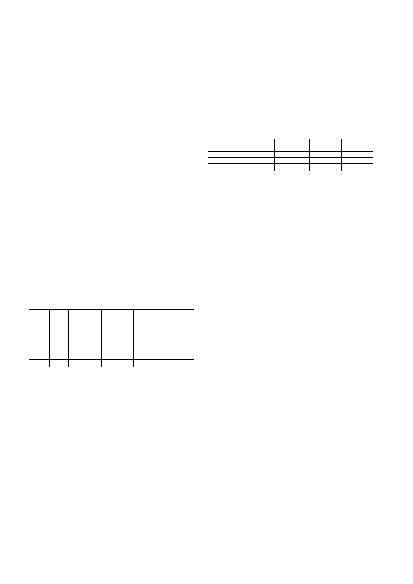
LagoonMax. Surface area SalinityAnthropogenic sources
depth(ha)
Biguglia1.8 m15004 - 26 ‰Urban and industrial
wastes
(Mesohaline)Agriculture
Leaching of watershed
Diana
26-44 ‰Aquaculture activities
(Euhaline)Agriculture
Urbino9.2 m76026-44 ‰Aquaculture activities
Biotope
Biguglia lagoon Diana lagoonUrbino
lagoon
Sand
2.6
7.9
9.2
Silt
77.0
88.1
70.1
Photophilous algae photophiles6.5
Table II: Surface area (expressed as a %) of the assemblages and bot-
tom types in the Corsican lagoons of Biguglia, Diana and Urbino.
Table I: Characteristics of the study sites. The scale used for salinity is
that adopted by the Venice Committee/Commission (2).